Weather
Connecticut Weather: Flood Watch Issued As Storm Approaches
And there is the chance for more snow in the forecast for Connecticut. Here's the latest details on the rollercoaster type forecast.


A week ago, the high temperature in Connecticut was around 10 degrees and on Friday it's likely that parts of the state will be in the 60s. Unfortunately, with the milder air, also comes new weather concerns. The National Weather Service has issued a Flood Watch for all of Connecticut on Friday and Saturday.
The state could see up to three inches of rain that could cause flooding as snow and ice continue to melt. Also temps will plummet on Saturday and some of the rain could end as ice. The warm temps won't last as the Sunday daytime highs are back below the freezing mark. Connecticut could see more snow on Tuesday/Wednesday too.
The National Weather Service says for Southern Connecticut, "Moderate to heavy rain Friday into Saturday... Temperatures are forecast to warm well into the 50s Friday. A period of moderate to locally heavy rain will also move through the area Friday into Saturday. Rainfall amounts of 1 to 3 inches with potentially locally higher amounts, are expected during this time. The combination of melting snow and periods of rain should allow rivers and streams to rise, breaking up the ice, and potentially allowing ice jams to form. Rivers and streams could see sudden rises in vicinity of these ice jams."
Find out what's happening in Greenwichfor free with the latest updates from Patch.
For Hartford and Tolland counties, the weather service says, "Heavy rain is expected to overspread the region Friday afternoon and evening continuing at times into Saturday morning. This combined with rapid snow melt will result in the possibility of some river and stream flooding along with the potential for isolated ice jam flooding. The heavy rainfall combined with snow clogged storm drains may also result in the potential for significant urban/street flooding. This has the potential to impact the Friday evening commute."
WTNH News 8 Meteorologist Gil Simmons said, "for your Thursday - Cloudy & dry with 40s today. Lots of spray on your windshield from snow melting. Heavy rain Friday-Saturday Morning. May end as a brief mix as cold air arrives. Cold next week with snow possible Wednesday!
Find out what's happening in Greenwichfor free with the latest updates from Patch.
NBC Connecticut Meteorologist Ryan Hanrahan said, "Heavy rain and warmer temperatures for Friday but what about Saturday? Temperatures will drop rapidly in the morning and we may have to deal with a flash freeze or some ice. We're watching it closely."
See also: Woman Throws Pizza At Husband, Charged By Police: Report
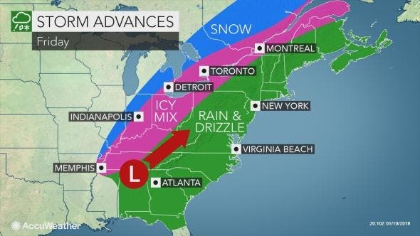
image via Accuweather.com
Here is the updated weather forecast for Southern Connecticut:
Today: Areas of fog before noon. Otherwise, partly sunny, with a high near 50. South wind 5 to 7 mph.
Tonight: A 50 percent chance of rain, mainly after 1am. Patchy fog after 8pm. Otherwise, mostly cloudy, with a low around 45. South wind 5 to 10 mph.
Friday: Rain. The rain could be heavy at times. Widespread fog. High near 56. South wind 11 to 15 mph. Chance of precipitation is 100%. New precipitation amounts between 1 and 2 inches possible.
Friday Night: Rain. Widespread fog. Low around 40. South wind around 10 mph. Chance of precipitation is 100%. New precipitation amounts between a half and three quarters of an inch possible.
Saturday: Rain, mainly before noon. Widespread fog before 3pm. High near 46. North wind 10 to 14 mph. Chance of precipitation is 80%. New precipitation amounts between a tenth and quarter of an inch possible.
Saturday Night: Mostly cloudy, with a low around 19.
Sunday: Mostly sunny, with a high near 28.
Sunday Night: Partly cloudy, with a low around 14.
Here is the updated weather forecast for Hartford and Tolland counties:
Today: Areas of fog before 10am, then areas of fog after 4pm. Otherwise, mostly cloudy, with a high near 49. South wind 3 to 6 mph.
Tonight: A slight chance of rain before 11pm, then showers, mainly after 4am. Areas of dense fog. Low around 43. South wind 5 to 8 mph. Chance of precipitation is 80%. New precipitation amounts of less than a tenth of an inch possible.
Friday: Showers before 7am, then rain between 7am and 4pm, then rain and possibly a thunderstorm after 4pm. Some of the storms could produce heavy rainfall. Areas of fog. High near 57. South wind 9 to 15 mph, with gusts as high as 31 mph. Chance of precipitation is 100%. New rainfall amounts between three quarters and one inch possible.
Friday Night: Rain and possibly a thunderstorm. Areas of fog. Low around 40. South wind 5 to 10 mph becoming light after midnight. Winds could gust as high as 28 mph. Chance of precipitation is 100%. New rainfall amounts between three quarters and one inch possible.
Saturday: Rain before 1pm, then a chance of freezing drizzle between 1pm and 2pm, then a chance of freezing drizzle and sleet after 2pm. Areas of fog. High near 41. North wind 8 to 14 mph. Chance of precipitation is 100%.
Saturday Night: A slight chance of snow and sleet before 8pm, then a slight chance of snow between 8pm and 11pm. Mostly cloudy, with a low around 16. Chance of precipitation is 20%.
Sunday: Mostly sunny, with a high near 27.
Sunday Night: Partly cloudy, with a low around 11.
Get more local news delivered straight to your inbox. Sign up for free Patch newsletters and alerts.


