Weather
Connecticut Weather Forecast: Winter Weather Advisory Issued
It's time to find your snow shovel and check to see if your snow blower works. Our first accumulating snow is on its way.


A Winter Weather Advisory has been issued for the entire state of Connecticut for up to six inches of snow Saturday that will begin during the morning hours and continue until early Sunday morning, the National Weather Service says.
Southern Connecticut is looking at between 4-6 inches and northern Connecticut is expected to receive 3-6 inches. More snow is possible on Tuesday too, according to the National Weather Service.
In its Friday morning update, the National Weather Service states for southern Connecticut:
Find out what's happening in Greenwichfor free with the latest updates from Patch.
* WHAT...Snow expected. Plan on hazardous travel conditions. Total snow accumulations of 4 to 6 inches are expected. * WHEN...From 6 AM Saturday to 6 AM EST Sunday. Highest snow accumulation should occur Saturday morning into Saturday evening.
For Hartford and Tolland counties, the weather service says:
Find out what's happening in Greenwichfor free with the latest updates from Patch.
* WHAT...Snow expected. Plan on difficult travel conditions. Total snow accumulations of 3 to 6 inches are expected. * WHEN...From 4 AM Saturday to 7 AM EST Sunday. Highest snow accumulations should occur Saturday morning into the evening hours.*
FOX 61 Weather's Matt Scott said, “A WINTER WEATHER ADVISORY means just that: be advised! snow arriving Sat afternoon - as we get a few inches, we'll see problems on the road in time for Sat night parties. BE CAREFUL!"
“Expect the full brunt of Saturday snow towards afternoon/evening. Heavier snow falls on the Eastern side of CT. The rest? Enough to cause issues on the way to holiday parties Saturday night," Scott said.
NBC Connecticut Meteorologist Ryan Hanrahan said, “Nice consensus on the GEFS. Probably a bit overdone but I'm comfortable with the 3-6" forecast after seeing the op Euro.”
WTNH News 8 Meteorologist Gil Simmons said that the first flakes will start around daybreak Saturday and there will be steady snow during the day before it winds down by 11 p.m. He is also predicting 3-6 inches of snow. On the plus side, Sunday will be quiet.
See also: 5 Massage Parlors Shut Down: Police
Restaurant Employee Stole $34k: PD
CT Man Illegally Transported Kingsnakes: Feds
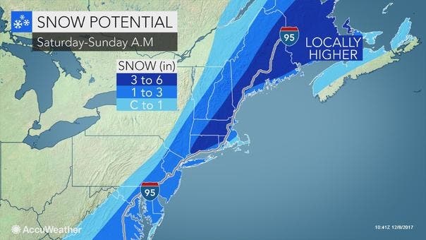
image via Accuweather.com
Here is the updated weather forecast for southern Connecticut via the National Weather Service:
Today: Mostly cloudy, with a high near 43. Wind chill values between 25 and 35. Southwest wind around 8 mph.
Tonight: A 30 percent chance of snow after 4am. Cloudy, with a low around 30. West wind 3 to 8 mph.
Saturday: Snow, mainly after 10am. High near 33. Wind chill values between 25 and 30. Calm wind becoming north 5 to 9 mph in the morning. Chance of precipitation is 80%. New snow accumulation of 2 to 4 inches possible.
Saturday Night: Snow, mainly before 1am. Steady temperature around 33. Wind chill values between 25 and 30. North wind 8 to 10 mph. Chance of precipitation is 80%. New snow accumulation of 1 to 2 inches possible.
Sunday: Mostly sunny, with a high near 39. West wind 10 to 17 mph, with gusts as high as 29 mph.
Sunday Night: Partly cloudy, with a low around 26.
Here is the updated weather forecast for northern Connecticut via the National Weather Service:
Today: Partly sunny, with a high near 42. Calm wind becoming southwest 5 to 7 mph in the afternoon.
Tonight: Mostly cloudy, with a low around 26. Light and variable wind.
Saturday: Snow, mainly after noon. High near 33. Calm wind becoming north around 6 mph in the afternoon. Chance of precipitation is 80%. New snow accumulation of 2 to 4 inches possible.
Saturday Night: Snow, mainly before 2am. Low around 27. North wind 5 to 7 mph. Chance of precipitation is 90%. New snow accumulation of 1 to 2 inches possible.
Sunday: A slight chance of snow before 7am, then a slight chance of snow showers between 7am and 3pm. Partly sunny, with a high near 37. West wind 7 to 10 mph, with gusts as high as 23 mph. Chance of precipitation is 20%.
Sunday Night: Partly cloudy, with a low around 22.
Get more local news delivered straight to your inbox. Sign up for free Patch newsletters and alerts.