Community Corner
'Frozen' In Mansfield -- Wintry Mix Expected in Mansfield-Storrs
Full details of the forecast for the stormy weekend.

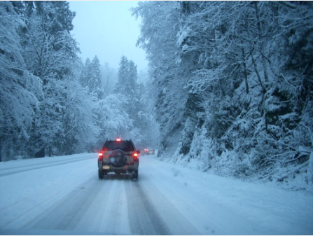
Snow, sleet and ice — that’s the mixed frozen bag being forecast by The National Weather Service that’s issued a hazardous weather outlook and winter weather advisory beginning at midnight Friday, continuing through 7 p.m. Saturday.
[The League of Women’s Voters of Northeast Connecticut event scheduled for Saturday has been cancelled.]
Precipitation is expected be heavy snow with some light ice accumulations, according to the National Weather Service. Four to eight inches of snow are expected, beginning very early Saturday. It could mix with freezing rain and sleet, and even possibly rain before changing back to snow Saturday afternoon and evening.
Find out what's happening in Mansfield-Storrsfor free with the latest updates from Patch.
The weather service advises that travel will be difficult and that large branches and wires could be brought down by the snow and ice, and wind gusts up to 20 mph. Visibility will be limited to a quarter mile at times.
The full forecast is below. Sign up for Mansfield-Storrs Patch news alerts to stay on top of the latest weather developments and more, by clicking here.
Find out what's happening in Mansfield-Storrsfor free with the latest updates from Patch.
- Tonight: Snow likely, mainly after 4am. Increasing clouds, with a low around 26. Southwest wind around 5 mph becoming calm in the evening. Chance of precipitation is 60%. Total nighttime snow accumulation of less than one inch possible.
- Saturday: Snow and sleet, possibly mixed with freezing rain, becoming all snow after 3pm. High near 33. Light and variable wind becoming north 6 to 11 mph in the morning. Chance of precipitation is 100%. New snow and sleet accumulation of 3 to 7 inches possible.
- Saturday Night: A chance of snow before 9pm. Cloudy, then gradually becoming partly cloudy, with a low around 22. West wind 8 to 11 mph. Chance of precipitation is 40%. New snow accumulation of less than a half inch possible.
- Sunday: Mostly sunny, with a high near 33. Northwest wind 9 to 14 mph, with gusts as high as 26 mph.
- Sunday Night: Mostly cloudy, with a low around 12. North wind 5 to 8 mph.
- Monday: A slight chance of snow showers after noon. Mostly cloudy, with a high near 21. Chance of precipitation is 20%.
- Monday Night: Mostly cloudy, with a low around 7.
- Tuesday: Partly sunny, with a high near 19.
- Tuesday Night: Partly cloudy, with a low around 4.
- Wednesday: Mostly sunny, with a high near 23.
- Wednesday Night: Partly cloudy, with a low around 9.
Have a news tip? Email barbara.heins@patch.com.
Get more local news delivered straight to your inbox. Sign up for free Patch newsletters and alerts.