Home & Garden
Mansfield's Stormy and Warmer Weekday Forecast
It's going to be cloudy with a chance of showers and thunderstorms for the next couple of days.

By Barbara Heins and Brian McCready (Patch Staff)
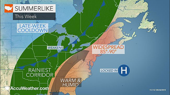
After an amazing holiday weather weekend it’s back to reality starting on Wednesday.
Enjoy the rest of Tuesday as it feels like a summer day with sunny skies and temps in the low to mid 80s.
Find out what's happening in Mansfield-Storrsfor free with the latest updates from Patch.
Beginning tonight the weather changes and there is a chance of showers and occasional thunderstorms continuing into Wednesday and Thursday. Temperatures will be in the mid 70s on the shoreline and low 80s in interior sections.
On Friday the precipitation stops but skies remain cloudy with temps in the mid 70s on the shoreline to low 80s inland.
Find out what's happening in Mansfield-Storrsfor free with the latest updates from Patch.
But the sun does return for one day on Saturday with temps around 80 degrees. And more showers possible for Sunday.
Here is Mansfield’s latest hyperlocal National Weather Service forecast:
- Tonight: Isolated showers and thunderstorms before 7pm, then isolated showers and thunderstorms after midnight. Patchy fog after 4am. Otherwise, cloudy, with a low around 62. South wind 5 to 9 mph. Chance of precipitation is 20%.
- Wednesday: A chance of showers and thunderstorms, mainly after 4pm. Some of the storms could produce heavy rain. Areas of fog before 9am. Otherwise, mostly cloudy, with a high near 78. South wind 5 to 11 mph, with gusts as high as 22 mph. Chance of precipitation is 30%. New rainfall amounts between a tenth and quarter of an inch, except higher amounts possible in thunderstorms.
- Wednesday night: A chance of showers and thunderstorms, mainly after 10pm. Patchy fog after 5am. Otherwise, mostly cloudy, with a low around 63. South wind 5 to 10 mph, with gusts as high as 20 mph. Chance of precipitation is 40%. New rainfall amounts of less than a tenth of an inch, except higher amounts possible in thunderstorms.
- Thursday: A chance of showers and thunderstorms. Patchy fog before 9am. Otherwise, mostly cloudy, with a high near 77. Southwest wind 3 to 8 mph. Chance of precipitation is 40%.
- Thursday night: A chance of showers and thunderstorms. Patchy fog after 3am. Otherwise, mostly cloudy, with a low around 62. Chance of precipitation is 30%.
- Friday: A chance of showers before 10am. Patchy fog before 7am. Otherwise, partly sunny, with a high near 79. Chance of precipitation is 30%.
- Friday night: Patchy fog after 4am. Otherwise, mostly cloudy, with a low around 61.
- Saturday: Patchy fog before 7am. Otherwise, partly sunny, with a high near 81.
- Saturday night: A chance of showers and thunderstorms. Mostly cloudy, with a low around 61. Chance of precipitation is 40%.
- Sunday: A chance of showers. Mostly cloudy, with a high near 72. Chance of precipitation is 40%.
Photo Credit: Accuweather.com
Get more local news delivered straight to your inbox. Sign up for free Patch newsletters and alerts.