Community Corner
Latest Details on Connecticut's Snowy Monday Morning Commute
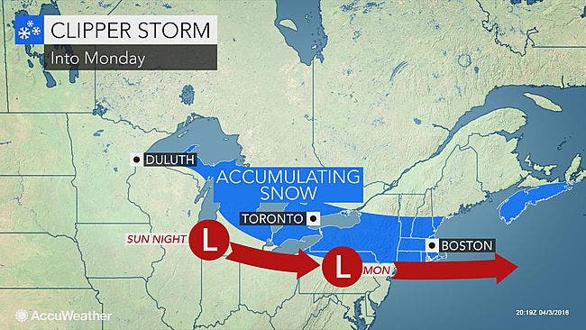
The entire state may see snowflakes during the morning and a "Winter Weather Advisory" has been issued for northern Connecticut.

UPDATE 6:20 P.M.
Monday’s morning commute could be tricky, especially in northern Connecticut.
It appears the entire state could see snowflakes during the morning commute, but only Hartford and Tolland counties have been issued a “Winter Weather Advisory.”
The immediate Connecticut coastline is under a “Freeze Warning” because temps will fall back to 30 degrees. At one point Sunday 16,000 Connecticut residents were without power but as of 6 p.m. that number has decreased to 2,700 people including: Weston, 230, Glastonbury, 357, and 211 Greenwich residents.
In Hartford and Tolland counties the “Winter Weather Advisory” is from 3 a.m. to 8 p.m. Monday. Snow could accumulate 3 to 6 inches. The snow will begin around 5 a.m. to 7 a.m. and continue until mid afternoon and possibly early evening, the weather service writes.
Temps will be in the mid to upper 20s in northern Connecticut and “expect snow to accumulate on roadways making for a slippery commute,” according to the National Weather Service.
The evening commute home may also be difficult in Hartford and Tolland counties because temps will be below freezing and road could be slippery.
Southern Connecticut snow?
Snow is possible after 2 a.m. in Fairfield, New Haven, Middlesex, and New London counties and will turn to plain rain by 8 a.m. on the immediate Connecticut coastline from Greenwich to New London, and interior sections could see it remain all snow until 11 a.m. Monday.
The immediate Connecticut coastline may see a coating or up to half an inch of snow while interior sections could see an inch or two of accumulation in certain spots. The precipitation ends by 8 p.m. Monday. During the day on Monday the shoreline sees all rain while there could be some mixing inland.
On the shoreline temps will be near 40 degrees but inland the temps only reach into the upper 30s.
On Monday, temps go all the way down to the mid 20s for all of southern Connecticut.
And, the only day we’re in the 50s this week is Thursday and of course that means it will rain.
NBC Connecticut Meteorologist Ryan Hanrahan writes, "Snow will be flying most of the day tomorrow (except at the shore where it will be mixed with rain) but accumulation will be limited on paved surfaces. With a bit of salt I expect most roads will be fine tomorrow with up to a couple inches on grassy surfaces - especially in the hills. This doesn't look like a big deal though some slick spots are possible during the AM commute."
Other top stories in Connecticut:
- 17 Connecticut Employers Make Forbes Top 500 List
- CT Heroin Epidemic: Interactive Map of Deaths by Town
- Peyton Manning Heading to CT to Feed Seals?; Resident Wins HGTV 'Dream Home'; Cop Saves Choking Child's Life: Nearby News
UPDATE: As of 2:30 p.m. more than 6,000 Connecticut residents are still without power including: Newtown, 464, Cheshire 324, Darien, 253, Guilford, 268, New Canaan, 120, Oxford, 110, Greenwich, 237, and Danbury, 153.
UPDATE: As of 12:30 p.m. 8,200 Connecticut residents are currently without power.
UPDATE: As of 11:30 a.m. 11,110 Connecticut residents are currently without power and here are the towns reporting the most outages: New Canaan, 837, Guilford, 828, Newtown, 754, Greenwich, 955, Durham, 186, Tolland, 377, Haddam, 100, Branford, 347, Darien, 182, Oxford, 109, Ridgefield, 212, Mansfield, 70, New Milford, 118, Farmington, 106, Norwalk, 209, Danbury, 157, and Madison, 63.
At its height there were about 16,000 people without power around 9 a.m.
Keep checking back for updates on the power outages and snow potential for tonight.
UPDATE: As of 10:30 a.m Eversource is reporting 13,500 outages now in Connecticut, which is a 2,500 reduction in the past 45 minutes. We'll keep updating this story.
As of 9:45 a.m. nearly 16,000 Connecticut residents are without power as high winds were whipping across the state and even dumping snow in some locations.
As of 9:30 a.m. Eversource is reporting 15,676 outages including: Guilford, 1,606, Greenwich, 1,276, Madison, 627, Branford, 694, Wilton, 636, Tolland, 428, Woodbury, 238, Durham, 223, Southington, 131, Middlefield, 74, Middletown, 616, East Hampton, 112, Newtown, 124, New Milford, 153, Ridgefield, 190, South Windsor, 127, and Danbury, 310.
The High Wind Warning first ends in Hartford and Tolland counties by 11 a.m., northern parts of Fairfield, New Haven, Middlesex, and New London counties at 2 p.m. and not until 6 p.m. on the immediate Connecticut coastline from Greenwich to New London.
During the High Wind Warning period you can expect winds between 20-40 mph and some gusts approaching 60 mph.
Winter Weather Advisories that were issued for interior sections of southern Connecticut along with Hartford and Tolland counties expires Sunday morning.
For the rest of Sunday, some snow showers are possible, it will still feel windy but it will mostly be sunny with temps near 40 degrees.
Check out this thunder snow in West Hartford this morning. The snow and wind are already causing problems on the roads. Here's the latest on the storm -> http://nbcct.co/QNzzY5m
Posted by NBC Connecticut on Sunday, April 3, 2016
Snow chance Sunday night/Monday morning
Once again, the chance for real accumulation is in northern Connecticut in Hartford and Tolland counties. In Tolland County, snow, which will begin around daybreak Monday and last into the afternoon, you could see 3-5 inches of snow. Hartford County’s timeline is the same and 2-4 inches of snow is possible there.
For southern Connecticut, the National Weather Service says up to an inch of snow is possible for Fairfield, New Haven, Middlesex, and New London counties.
Snow will develop after 2 a.m. and mix with rain and some freezing rain, and return to some snow too, which could produce a slushy very minor accumulation of an inch of snow during the day on Monday. The high temperature on Monday will be near 40 degrees.
Photo credit: Accuweather.com
Catch up on the top stories of the week and year in Connecticut:
Get more local news delivered straight to your inbox. Sign up for free Patch newsletters and alerts.