Weather
Power Outages In CT: 34,000 Without Electricity: UPDATE
A powerful storm caused school delays and closings. Hundreds of streets across Connecticut were closed from falling tree limbs and wires.


CONNECTICUT — More than 40,000 Connecticut electric customers woke up without power Thursday morning after a "bomb cyclone" nor'easter barreled through the state overnight. The storm brought flooding rains, wind gusts in excess of 50 mph, and resulted in some schools even closing. Hundreds of roads were made impassable due to falling tree limbs and utility wires.
There are wind advisories and warnings still up across the state as gusts may approach 50 mph throughout the day. This won't help with power restoration efforts.
Eversource is reporting more than 33,000 outages in its service area as of 3 p.m. Somers, Stonington, Vernon and Old Lyme have more than 1,000 outages each.
Find out what's happening in Milfordfor free with the latest updates from Patch.
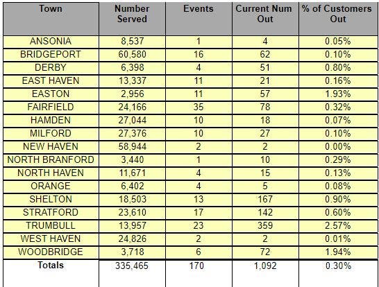
United Illuminating Co. is reporting around 1,100 power outages as of 3 p.m. Thursday. Trumbull has the most outages at 359 followed by Shelton at 167 and Stratford at 142.
The storm left a ton of damage across Connecticut. New London Fire Department said there were several storm related emergencies. Multiple people were rescued from vehicles stranded, one person was removed from a basement apartment.
Find out what's happening in Milfordfor free with the latest updates from Patch.
Several roads are closed in South Windsor and schools there are on a two hour delay.
Darien Police say "Several road closures reported as a result of the storm. Stay away from downed trees/wires. Currently blocked by trees/wires: Hollow Tree/Miles, Walmsley, Stanton, Stonybrook, Winding Ln, Old Kings Hwy S., Shennamere, Hoyt Ct, Colony Rd."
Greenwich is reporting numerous road closures including:
ROAD CLOSURES:-North Street between Taconic and Dingletown -30 Fairfield Road -300 N Maple Avenue -Byram Road at the RR bridge -165 Henry Street
LOW Wires: -1300 block of King Street -600 block of Lake Avenue
"Indian Field Road closed between the Town’s Fleet Department and Bruce Park Drive for downed primaries," Greenwich officials say. "50 Cat Rock Road closed, tree and wires blocking entire roadway. Greenwich Public Schools on a two hour delay today. Please drive safely."
These roads are closed in Wilton:
"Route 33 (Ridgefield Road) - between Belden Hill Road and Middlebrook Farm Road, Sturges Ridge Road near # 35, Stirrup Lane near #18, Indian Hill Road near Pin Oak Lane, Mountain Road near Scribner Hill Road, Wilridge Road near #64
Simsbury officials say Hopbrook Road is closed due to downed tree and wires. A number of trees and limbs are down in town.
West Hartford officials say, "Several traffic signals not functioning due to power outages. Yield and stop at intersection where lights are out. Drive Safe Be Safe."
Westport Police say "Bayberry Lane is still closed at Dorchester Drive due to the severe weather last night. There are low hanging wires that will not allow bus or commercial traffic to pass. Eversource has been notified but were unable to provide any time frame for service. Please use North Avenue or Sturges Highway to bypass the closure."
These are the current traffic issues in West Hartford:
Traffic Alert 1439 Boulevard (Eastbound from Troutbrook Drive closed)
193 North Quaker (Impassable in both directions)
Asylum Ave @ North Quaker (Impassable in all directions)
75 Shadow Lane (Impassable)
25 Knollwood (Impassable) #WeHa
The Southington Fire Department says, "County Rd. @ Defashion St. is closed due to multiple trees and utility poles across the road."
Norwalk officials say "Cranbury Park is currently closed to clean up debris from the parking areas and walkways that fell during the recent storm. Thank you for your patience as we work hard to reopen."
Below are outage figures from Eversource
| Area Name | Customers Affected | Customers Served | Percent Out |
|---|---|---|---|
| ANDOVER | 50 | 1424 | 3.511235955 |
| ASHFORD | 769 | 2197 | 35.00227583 |
| AVON | 278 | 8711 | 3.191367237 |
| BARKHAMSTED | 137 | 1788 | 7.662192394 |
| BEACON FALLS | 0 | 2817 | 0 |
| BERLIN | 10 | 9253 | 0.108073057 |
| BETHANY | 16 | 2368 | 0.675675676 |
| BETHEL | 7 | 8879 | 0.078837707 |
| BETHLEHEM | 129 | 1928 | 6.690871369 |
| BLOOMFIELD | 57 | 10607 | 0.537380975 |
| BOLTON | 324 | 2256 | 14.36170213 |
| BRANFORD | 267 | 16598 | 1.608627545 |
| BRIDGEWATER | 44 | 972 | 4.526748971 |
| BRISTOL | 127 | 29834 | 0.425688811 |
| BROOKFIELD | 6 | 8450 | 0.071005917 |
| BROOKLYN | 351 | 3666 | 9.574468085 |
| BURLINGTON | 178 | 3888 | 4.5781893 |
| CANAAN | 78 | 1315 | 5.931558935 |
| CANTERBURY | 586 | 2277 | 25.73561704 |
| CANTON | 250 | 5018 | 4.982064568 |
| CHAPLIN | 2 | 1121 | 0.178412132 |
| CHESHIRE | 368 | 11496 | 3.201113431 |
| CHESTER | 87 | 1986 | 4.380664653 |
| CLINTON | 63 | 7129 | 0.883714406 |
| COLCHESTER | 28 | 7291 | 0.384035112 |
| COLEBROOK | 99 | 825 | 12 |
| COLUMBIA | 63 | 2487 | 2.533172497 |
| CORNWALL | 161 | 1209 | 13.31679074 |
| COVENTRY | 297 | 5655 | 5.25198939 |
| CROMWELL | 37 | 7138 | 0.51835248 |
| DANBURY | 396 | 37356 | 1.060070671 |
| DARIEN | 85 | 8071 | 1.053153265 |
| DEEP RIVER | 46 | 2474 | 1.859337106 |
| DURHAM | 272 | 3127 | 8.698433003 |
| EAST GRANBY | 29 | 2658 | 1.091045899 |
| EAST HADDAM | 75 | 4931 | 1.520989657 |
| EAST HAMPTON | 82 | 6289 | 1.303863889 |
| EAST HARTFORD | 63 | 23230 | 0.271201033 |
| EAST LYME | 758 | 10099 | 7.505693633 |
| EAST WINDSOR | 506 | 6292 | 8.041958042 |
| EASTFORD | 0 | 919 | 0 |
| EASTON | 0 | 0 | 0 |
| ELLINGTON | 945 | 7698 | 12.27591582 |
| ENFIELD | 171 | 19454 | 0.878996607 |
| ESSEX | 75 | 4025 | 1.863354037 |
| FAIRFIELD | 0 | 22 | 0 |
| FARMINGTON | 41 | 12777 | 0.320889098 |
| FRANKLIN | 4 | 1024 | 0.390625 |
| GLASTONBURY | 61 | 16714 | 0.364963504 |
| GOSHEN | 30 | 1919 | 1.563314226 |
| GRANBY | 189 | 4890 | 3.865030675 |
| GREENWICH | 602 | 28225 | 2.132860939 |
| GRISWOLD | 728 | 3419 | 21.29277567 |
| GROTON | 315 | 5623 | 5.601991819 |
| GUILFORD | 96 | 11042 | 0.869407716 |
| HADDAM | 149 | 3967 | 3.755986892 |
| HAMDEN | 0 | 11 | 0 |
| HAMPTON | 21 | 889 | 2.362204724 |
| HARTFORD | 82 | 59003 | 0.138975984 |
| HARTLAND | 5 | 874 | 0.57208238 |
| HARWINTON | 124 | 2567 | 4.830541488 |
| HEBRON | 62 | 3975 | 1.559748428 |
| KENT | 119 | 2146 | 5.545200373 |
| KILLINGLY | 881 | 8894 | 9.905554306 |
| KILLINGWORTH | 37 | 2878 | 1.28561501 |
| LEBANON | 0 | 2227 | 0 |
| LEDYARD | 366 | 6793 | 5.387899308 |
| LISBON | 1 | 1872 | 0.053418803 |
| LITCHFIELD | 345 | 4719 | 7.310870947 |
| LYME | 21 | 1343 | 1.56366344 |
| MADISON | 104 | 9187 | 1.132034396 |
| MANCHESTER | 950 | 29189 | 3.254650725 |
| MANSFIELD | 424 | 7452 | 5.689747719 |
| MARLBOROUGH | 17 | 2652 | 0.641025641 |
| MERIDEN | 38 | 28262 | 0.13445616 |
| MIDDLEBURY | 40 | 3526 | 1.134429949 |
| MIDDLEFIELD | 0 | 2227 | 0 |
| MIDDLETOWN | 94 | 23102 | 0.406891178 |
| MONROE | 77 | 7978 | 0.965154174 |
| MONTVILLE | 327 | 8066 | 4.054054054 |
| MORRIS | 23 | 1407 | 1.634683724 |
| NAUGATUCK | 2 | 14497 | 0.013795958 |
| NEW BRITAIN | 14 | 34734 | 0.040306328 |
| NEW CANAAN | 54 | 8476 | 0.637092968 |
| NEW FAIRFIELD | 50 | 6081 | 0.822233185 |
| NEW HARTFORD | 316 | 3311 | 9.543944428 |
| NEW LONDON | 272 | 13893 | 1.957820485 |
| NEW MILFORD | 103 | 13974 | 0.737083154 |
| NEWINGTON | 2 | 14823 | 0.013492545 |
| NEWTOWN | 70 | 11376 | 0.61533052 |
| NORFOLK | 54 | 1117 | 4.834377798 |
| NORTH BRANFORD | 0 | 49 | 0 |
| NORTH CANAAN | 50 | 1464 | 3.415300546 |
| NORTH STONINGTON | 760 | 2618 | 29.02979374 |
| NORWALK | 65 | 31673 | 0.205222113 |
| NORWICH | 0 | 5 | 0 |
| OLD LYME | 1455 | 5503 | 26.44012357 |
| OLD SAYBROOK | 378 | 7138 | 5.295601009 |
| OXFORD | 10 | 5592 | 0.178826896 |
| PLAINFIELD | 304 | 7250 | 4.193103448 |
| PLAINVILLE | 81 | 9469 | 0.855422959 |
| PLYMOUTH | 30 | 5808 | 0.516528926 |
| POMFRET | 21 | 1922 | 1.092611863 |
| PORTLAND | 3 | 4653 | 0.064474533 |
| PRESTON | 84 | 2230 | 3.766816143 |
| PROSPECT | 3 | 4201 | 0.071411569 |
| PUTNAM | 559 | 5231 | 10.68629325 |
| REDDING | 158 | 3829 | 4.126403761 |
| RIDGEFIELD | 188 | 10930 | 1.720036597 |
| ROCKY HILL | 12 | 10232 | 0.117279124 |
| ROXBURY | 46 | 1349 | 3.409933284 |
| SALEM | 32 | 1981 | 1.615345785 |
| SALISBURY | 265 | 2997 | 8.842175509 |
| SCOTLAND | 22 | 697 | 3.156384505 |
| SEYMOUR | 5 | 7662 | 0.065257113 |
| SHARON | 179 | 2166 | 8.264081256 |
| SHELTON | 0 | 1 | 0 |
| SHERMAN | 417 | 1993 | 20.92323131 |
| SIMSBURY | 461 | 11065 | 4.166290104 |
| SOMERS | 2258 | 4107 | 54.97930363 |
| SOUTH WINDSOR | 721 | 12215 | 5.902578797 |
| SOUTHBURY | 38 | 10004 | 0.379848061 |
| SOUTHINGTON | 37 | 20134 | 0.183768749 |
| SPRAGUE | 6 | 1456 | 0.412087912 |
| STAFFORD | 518 | 6304 | 8.217005076 |
| STAMFORD | 131 | 60931 | 0.214997292 |
| STERLING | 639 | 1667 | 38.33233353 |
| STONINGTON | 1856 | 10878 | 17.06195992 |
| SUFFIELD | 197 | 6351 | 3.101873721 |
| THOMASTON | 56 | 3860 | 1.450777202 |
| THOMPSON | 759 | 4685 | 16.20064034 |
| TOLLAND | 426 | 6134 | 6.944897294 |
| TORRINGTON | 109 | 18724 | 0.582140568 |
| TRUMBULL | 0 | 0 | 0 |
| UNION | 15 | 456 | 3.289473684 |
| VERNON | 1646 | 16407 | 10.03230329 |
| VOLUNTOWN | 453 | 1323 | 34.24036281 |
| WALLINGFORD | 0 | 2 | 0 |
| WARREN | 66 | 841 | 7.847800238 |
| WASHINGTON | 32 | 2627 | 1.218119528 |
| WATERBURY | 108 | 51735 | 0.208756161 |
| WATERFORD | 879 | 9812 | 8.958418263 |
| WATERTOWN | 389 | 10224 | 3.804773083 |
| WEST HARTFORD | 440 | 28775 | 1.529105126 |
| WESTBROOK | 24 | 4666 | 0.514359194 |
| WESTON | 85 | 3873 | 2.194681126 |
| WESTPORT | 45 | 12622 | 0.356520361 |
| WETHERSFIELD | 17 | 12513 | 0.135858707 |
| WILLINGTON | 3 | 2960 | 0.101351351 |
| WILTON | 95 | 7547 | 1.258778323 |
| WINCHESTER | 93 | 6141 | 1.514411334 |
| WINDHAM | 15 | 10303 | 0.145588663 |
| WINDSOR | 12 | 13423 | 0.089398793 |
| WINDSOR LOCKS | 3 | 6563 | 0.045710803 |
| WOLCOTT | 0 | 7058 | 0 |
| WOODBRIDGE | 0 | 28 | 0 |
| WOODBURY | 11 | 5198 | 0.211619854 |
| WOODSTOCK | 187 | 4187 | 4.46620492 |
UI Outages
Video above shows New London firefighters rescuing a trapped man during the storm.
My neighbor’s house after the storm last night #Stamford pic.twitter.com/MVkZ6xVS6B
— Jennifer Cuevas (@JenniferCU0919) October 17, 2019
Check out this tree that fell onto a house in New Britain on Chapel Street! The damage from last night's storm spread across multiple towns. You can share your storm damage photos by sending them to share61@fox61.com --> https://t.co/F6iu77zPbH pic.twitter.com/OCHscrPeE2
— FOX61 (@FOX61News) October 17, 2019
This tree, brought down by powerful winds in last night's storm, barely missed a trailer in East Windsor! Thank you JimKG for sending in these photos. If you want to share any storm damage photos you can send them to share61@fox61.com pic.twitter.com/Bn90kjhUa9
— FOX61 (@FOX61News) October 17, 2019
WOW....Report from Chris Uscinski: Absolutely crazy in Mystic/Noank right now. Just went down to the marinas. Parking lots flooding, boats slamming around, cars flooded, trees down, pictures don’t do justice. pic.twitter.com/8hXZwj4KYK
— eweather (@Eweather13) October 17, 2019
Flooding along Bank St in New London. #nbcct pic.twitter.com/ByBOJy2mRR
— Josh Cingranelli (@WeatherJosh) October 17, 2019
Thousands across #Connecticut are waking up in the dark. Some of you also dealing with downed trees/branches. A large tree came crashing down on this home in #WestHaven — causing significant damage to the roof and two bedrooms. You’ll hear from the homeowners on @WTNH until 8am! pic.twitter.com/WGRinEcSUX
— Brian Spyros (@BrianSpyros) October 17, 2019
STORM DAMAGE: More downed power lines along Moody Road in Enfield. Police have part of the road closed off. pic.twitter.com/Lk59QyW4ha
— Lissette Nuñez (@LissetteNunezTV) October 17, 2019
POLE DOWN: Loveland Hill Rd. Has a pole and wires down in Vernon. We are right across from Rockville High School were área residents are still without power this morning. @FOX61News pic.twitter.com/Dtt6fgsHzf
— Brian Didlake TV (@BrianDidlakeTV) October 17, 2019
Debris along RT 15 SB in #WALLINGFORD by exit 66 leading to lane restrictions #fox61 #cttraffic pic.twitter.com/HUlyKA1MNs
— Maggie Slysz (@maggieslysz) October 17, 2019
The wind blew my mailbox into the road last night, where it was apparently flattened by a vehicle or vehicles. pic.twitter.com/b5dk1Q7Yyi
— Matt DeRienzo (@mattderienzo) October 17, 2019
See also: Mom Found Dead In House Fire, Son Dies After Bridge Jump In CT
Car Drives Into Grocery Store, Injures Customer: Police
Downtown Eatery In Historic Location Opens
And if you're curious what's next with the weather here is the latest forecast:
Today
A 20 percent chance of showers after 8am. Mostly cloudy, with a high near 59. Breezy, with a west wind 20 to 25 mph, with gusts as high as 50 mph.
Tonight
Mostly cloudy, with a low around 47. Breezy, with a west wind 13 to 21 mph.
Friday
Mostly sunny, with a high near 60. Northwest wind around 14 mph, with gusts as high as 26 mph.
Friday Night
Mostly clear, with a low around 43. Northwest wind 8 to 11 mph.
Saturday
Sunny, with a high near 58. Northwest wind around 7 mph becoming southwest in the afternoon.
Saturday Night
Clear, with a low around 48.
Sunday
Mostly sunny, with a high near 64.
Sunday Night
Partly cloudy, with a low around 52.
Get more local news delivered straight to your inbox. Sign up for free Patch newsletters and alerts.