Weather
CT Weather: Hurricane Henri To Make Landfall Sunday
A hurricane and tropical storm warning have been issued for all of Connecticut as Hurricane Henri is expected to make landfall in CT.


CONNECTICUT — Henri is expected to make landfall in Connecticut Sunday evening, and hurricane and tropical storm warnings are in effect. Henri will either make landfall as a category one hurricane or a strong tropical storm.
Henri is expected to make landfall somewhere near Old Saybrook as the storm's track has shifted east slightly.
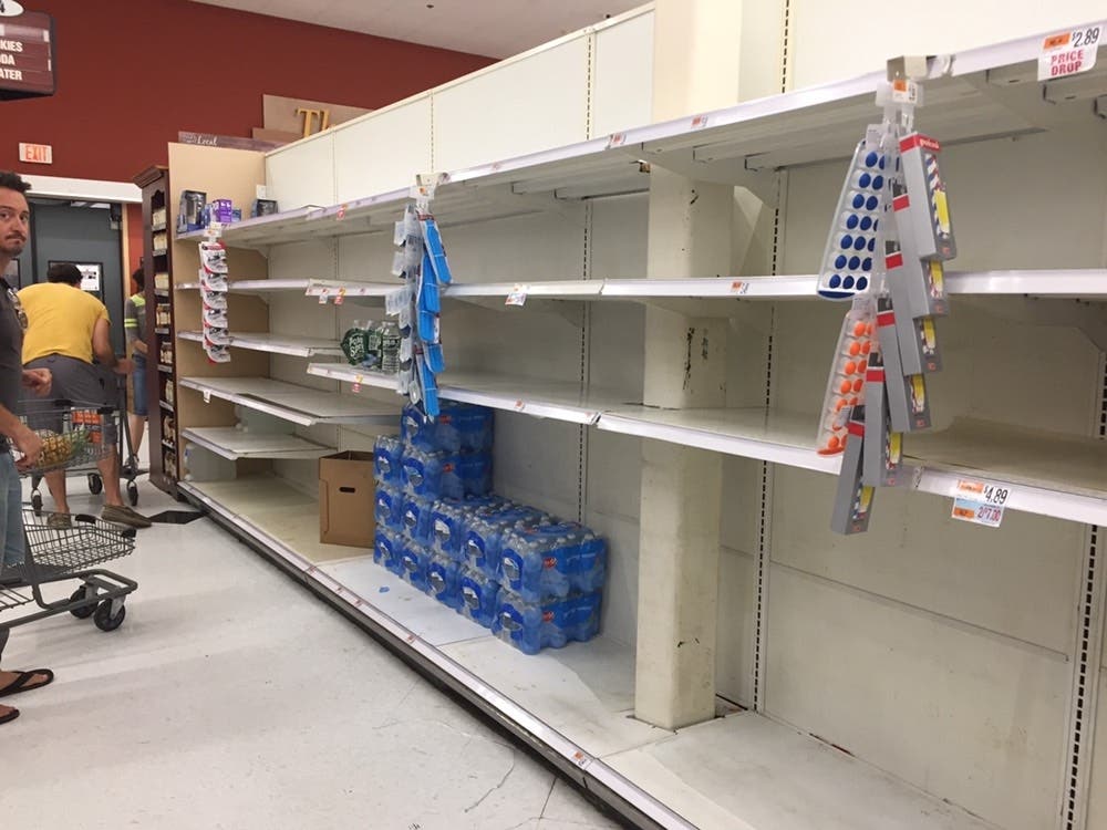
The long-duration storm will start kicking up wind and rain Sunday morning, and the tropical storm force wind gusts will continue all day Sunday. Monday will feature more rain. Several inches of rain is expected, which may lead to serious flooding concerns.
Find out what's happening in Milfordfor free with the latest updates from Patch.
Eversource has already estimated that between 50 and 69 percent of its 1.25 million customers in Connecticut could lose power, and restoration efforts could last between eight and 21 days.
With trees being the number one cause of power outages during storms and many of the state’s trees already weakened due to insects and saturated ground caused by recent storms – thousands of trees could come down during this hurricane, further complicating power restoration efforts, utility officials said.
Find out what's happening in Milfordfor free with the latest updates from Patch.
@CTRedCross is opening multiple shelters in advance of Hurricane #Henri. Shelters will open at 8 p.m. tonight and some tomorrow. They are available to individuals and families who need assistance. See thread below for locations. More info: https://t.co/b1IQ60Bxnn
— CT Red Cross (@CTRedCross) August 21, 2021
Here are the full list of shelters:
- Geraldine Johnson High School, Bridgeport
- Fitch High School, Groton
- Hill Regional Career High School, New Haven
- Winthrop STEM Elementary Magnet School, New London
- East Lyme Middle School, Niantic
- North Branford Intermediate School, North Branford
- Kelly Middle School, Norwich
- Stonington High School, Pawcatuck
- 6 a.m. - Brien McMahon High School, Norwalk
- 9 a.m. - Plainville High School, Plainville
Pretty significant jog east with our first set of evening (0z) guidance. Would lessen the wind threat across parts of CT but increase rain potential. Stay tuned - new NHC update coming at 11p. https://t.co/liRI6KZGyv
— Ryan Hanrahan (@ryanhanrahan) August 22, 2021
Max wind speed & direction will depend on Henri's intensity, location of landfall and the storm's motion. Initially wind direction will be favorable for water to pile into LI sound (why a storm surge up to 3' -5' is forecast). This model looks decent give or take 5-10 mph #fox61 pic.twitter.com/eqjYxF0sK0
— Rachel Frank (@RachelFrank_CT) August 22, 2021
Evacuations should be seriously considered for shoreline residents. Predicted storm surge is 3-5 ft. Not far off from Irene levels. https://t.co/xgfSqsMwkO
— Kaitlyn McGrath (@KaitlynMcGrath) August 21, 2021
See related: Governor Updates Residents On Hurricane Henri Preparation
Don't miss local and statewide news from all across Connecticut. Register for free Patch alerts and daily newsletters.
Originally classified as a tropical storm, Henri was upgraded to a Category 1 hurricane on Saturday.
We're suspending service on the New Haven line and Danbury/Waterbury/New Canaan branches tomorrow because of Hurricane Henri. Last train from GCT will be the 1:53a to Stamford. Last trains to GCT will be the 11:35p from New Haven and 12:58a from Stamford. https://t.co/Ln0Vj4KFRX
— Metro-North Railroad. Wear a Mask-Stop the Spread. (@MetroNorth) August 21, 2021
*******Here are the specific local forecast details for where you live in Connecticut, via the latest updates from the National Weather Service:
Coastal areas of Fairfield County
..STORM SURGE WARNING REMAINS IN EFFECT...
...TROPICAL STORM WARNING REMAINS IN EFFECT...
* LOCATIONS AFFECTED
- Stamford
- Norwalk
- Bridgeport
*WIND
- Peak Wind Forecast: 10-20 mph with gusts to 45 mph
* STORM SURGE
- LATEST LOCAL FORECAST: Life-threatening storm surge possible
- Peak Storm Surge Inundation: The potential for 2-4 feet above ground somewhere within surge prone areas
- Window of concern: Sunday morning until early Monday morning
*FLOODING RAIN
- LATEST LOCAL FORECAST: Flood Watch is in effect
- Peak Rainfall Amounts: Additional 2-4 inches, with locally higher amounts
*TORNADO
- Situation is unfavorable for tornadoes
Interior sections of Fairfield County
...TROPICAL STORM WARNING REMAINS IN EFFECT...
* LOCATIONS AFFECTED
- Danbury
- Ridgefield
- Trumbull
* WIND
- LATEST LOCAL FORECAST: Below tropical storm force wind
- Peak Wind Forecast: 10-20 mph with gusts to 40 mph
* STORM SURGE
- No storm surge inundation forecas
*FLOODING RAIN
- LATEST LOCAL FORECAST: Flood Watch is in effect
- Peak Rainfall Amounts: Additional 3-6 inches, with locally higher amounts
* TORNADO
- Situation is unfavorable for tornadoes
Coastal sections of New Haven County
...HURRICANE WARNING REMAINS IN EFFECT...
...STORM SURGE WARNING REMAINS IN EFFECT...
* LOCATIONS AFFECTED
- Milford
- New Haven
- Guilford
*LATEST LOCAL FORECAST: Equivalent Tropical Storm force wind
- Peak Wind Forecast: 25-35 mph with gusts to 60 mph
*STORM SURGE
- LATEST LOCAL FORECAST: Life-threatening storm surge possible
- Peak Storm Surge Inundation: The potential for 2-4 feet above ground somewhere within surge prone areas
- Window of concern: Sunday morning until early Monday morning
*FLOODING RAIN
- LATEST LOCAL FORECAST: Flood Watch is in effect
- Peak Rainfall Amounts: Additional 3-6 inches, with locally higher amounts
* TORNADO
- Situation is somewhat favorable for tornadoes
Interior sections of New Haven County
...HURRICANE WARNING REMAINS IN EFFECT...
* LOCATIONS AFFECTED
- North Haven
- Southbury
- Meriden
* WIND
- LATEST LOCAL FORECAST: Below tropical storm force wind
- Peak Wind Forecast: 15-25 mph with gusts to 40 mph
*FLOODING RAIN
- LATEST LOCAL FORECAST: Flood Watch is in effect
- Peak Rainfall Amounts: Additional 4-8 inches, with locally higher amounts
*TORNADO
- Situation is unfavorable for tornadoes
Coastal sections of Middlesex County
...HURRICANE WARNING REMAINS IN EFFECT...
...STORM SURGE WARNING REMAINS IN EFFECT...
* LOCATIONS AFFECTED
- Clinton
- Old Saybrook
- Essex
* WIND
- LATEST LOCAL FORECAST: Equivalent Strong Tropical Storm force
wind
- Peak Wind Forecast: 30-40 mph with gusts to 60 mph
- Window for Tropical Storm force winds: Sunday morning until early Monday morning
* STORM SURGE
- LATEST LOCAL FORECAST: Life-threatening storm surge possible
- Peak Storm Surge Inundation: The potential for 2-4 feet above ground somewhere within surge prone areas
- Window of concern: Sunday morning until early Monday morning
*FLOODING RAIN
- LATEST LOCAL FORECAST: Flood Watch is in effect
- Peak Rainfall Amounts: Additional 2-4 inches, with locally higher amounts
* TORNADO
- Situation is somewhat favorable for tornadoes
Inland sections of Middlesex County
...HURRICANE WARNING REMAINS IN EFFECT...
* LOCATIONS AFFECTED
- Chester
- Middletown
- East Hampton
* WIND
- Peak Wind Forecast: 20-30 mph with gusts to 50 mph
*FLOODING RAIN
- LATEST LOCAL FORECAST: Flood Watch is in effect
- Peak Rainfall Amounts: Additional 3-6 inches, with locally higher amounts
*TORNADO
- Situation is somewhat favorable for tornadoes
Coastal sections of New London County
...HURRICANE WARNING REMAINS IN EFFECT...
...STORM SURGE WARNING REMAINS IN EFFECT...
* LOCATIONS AFFECTED
- Old Lyme
- Groton
- Mystic
* WIND
- LATEST LOCAL FORECAST: Equivalent Tropical Storm force wind
- Peak Wind Forecast: 40-50 mph with gusts to 65 mph
- Window for Tropical Storm force winds: Sunday morning until early Monday morning
* STORM SURGE
- LATEST LOCAL FORECAST: Life-threatening storm surge possible
- Peak Storm Surge Inundation: The potential for 2-4 feet above ground somewhere within surge prone areas
- Window of concern: Sunday morning until early Monday morning
*FLOODING RAIN
- LATEST LOCAL FORECAST: Flood Watch is in effect
- Peak Rainfall Amounts: Additional 1-3 inches, with locally higher amounts
*TORNADO
- Situation is somewhat favorable for tornadoes
Inland sections of New London County:
...HURRICANE WARNING REMAINS IN EFFECT...
* LOCATIONS AFFECTED
- Montville
- Norwich
- Jewett City
* WIND
LATEST LOCAL FORECAST: Below tropical storm force wind
- Peak Wind Forecast: 25-35 mph with gusts to 50 mph
*FLOODING RAIN
- LATEST LOCAL FORECAST: Flood Watch is in effect
- Peak Rainfall Amounts: Additional 1-3 inches, with locally higher amounts
*TORNADO
- Situation is somewhat favorable for tornadoes
For all of Southern Connecticut
A flash flood watch is in effect through Monday morning
* A widespread rainfall of 3 to 6 inches is forecast in in association with Henri with localized higher amounts possible Saturday evening through Monday morning.
See also from across Connecticut:
- Man Charged After Pot Found In Daughter's Lunch Box: Police
- Connecticut Resident Wins $2 Million Lottery Prize
- High School Rising Senior Hopes To Help Others
- CT Coronavirus Red Zones Nearly Double In Past Week
- 'A Sad Number': 23 More COVID-19 Deaths Reported In CT This Week
Hartford County
...TROPICAL STORM WARNING IN EFFECT...
* LOCATIONS AFFECTED
- Hartford
- Windsor Locks
* WIND
- LATEST LOCAL FORECAST: Below tropical storm force wind
- Peak Wind Forecast: 15-25 mph with gusts to 35 mph
*FLOODING RAIN
- LATEST LOCAL FORECAST: Flood Watch is in effect
- Peak Rainfall Amounts: Additional 3-6 inches, with locally higher amounts
*TORNADO
- Situation is somewhat favorable for tornadoes
Tolland County
...TROPICAL STORM WARNING IN EFFECT...
* LOCATIONS AFFECTED
- Union
- Vernon
* WIND
- LATEST LOCAL FORECAST: Below tropical storm force wind
- Peak Wind Forecast: 20-30 mph with gusts to 35 mph
* FLOODING RAIN
- LATEST LOCAL FORECAST: Flood Watch is in effect
- Peak Rainfall Amounts: Additional 2-4 inches, with locally higher amounts
* TORNADO
- Situation is somewhat favorable for tornadoes
Windham County:
...TROPICAL STORM WARNING IN EFFECT...
* LOCATIONS AFFECTED
- Putnam
- Willimantic
* WIND
LATEST LOCAL FORECAST: Below tropical storm force wind
- Peak Wind Forecast: 20-30 mph with gusts to 40 mph
FLOODING RAIN
- LATEST LOCAL FORECAST: Flood Watch is in effect
- Peak Rainfall Amounts: Additional 1-3 inches, with locally higher amounts
TORNADO
- Situation is somewhat favorable for tornadoes
Litchfield County
...TROPICAL STORM WARNING REMAINS IN EFFECT...
* WIND
- LATEST LOCAL FORECAST: Below tropical storm force wind
- Peak Wind Forecast: 10-20 mph with gusts to 40 mph
*FLOODING RAIN
- LATEST LOCAL FORECAST: Flood Watch is in effect
- Peak Rainfall Amounts: Additional 3-6 inches, with locally higher amounts
TORNADO
- LATEST LOCAL FORECAST:
- Situation is unfavorable for tornadoes
Get more local news delivered straight to your inbox. Sign up for free Patch newsletters and alerts.