Home & Garden
Finally, Snow in the Forecast for Connecticut
We'll let you know when to expect the first possible accumulating snow and wintry mix of the season.


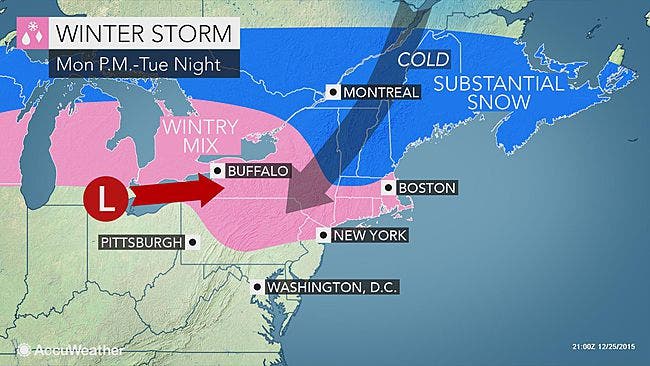
Fresh off of 70 degree temps on Christmas Eve and reports of some people hitting the beaches in Connecticut on Christmas Day, it only seems appropriate that we’re now talking about the first real snow/wintry mix chance of the year on the horizon.
The entire state of Connecticut is expected to receive some accumulation from the first real snow/wintry mix chance of the year, which is expected to begin Monday evening and continue until early Tuesday before it changes to all rain.
Already a “Hazardous Weather Outlook” has been issued for northern Fairfield, northern New Haven, northern Middlesex, and northern New London counties for the slight chance of up to six inches of snow/wintry mix before it’s all over.
Areas on the immediate Connecticut coastline including from Greenwich to New London are likely to receive more of a mix of snow, sleet and rain which will keep the accumulation to a slushy half inch or so.
Northern areas in Connecticut including Hartford and Tolland counties could see a prolonged period of snow beginnings after 5 p.m. Monday and continuing as mainly snow until around noon Tuesday. No accumulation estimations have been made as of yet for northern Connecticut.
Here is the detailed snow/mix forecast via the National Weather Service for the entire state as broken down by area:
Southern Connecticut/immediate coastline: On Monday temps, which are very warm to begin the day drop like a rock. A mix of snow and sleet is forecast beginning around 10 p.m. and continuing until 4 a.m. Tuesday. The mix will then change to all rain then. A half inch of accumulation of snow and ice is expected, which could impact the morning drive to work.
Southern Connecticut/northern Fairfield, New Haven, Middlesex, and New London counties: A wintry mix of snow, sleet and freezing rain late Monday night into Tuesday morning before precipitation changes to rain.
For this area, which has a “Hazardous Weather Outlook” issued already, the National Weather Service writes, “the probability of six inches of snow is slight at this time, but the first accumulating wintry mix of the season has potential to cause a Hazardous Tuesday morning commute.”
Hartford and Tolland counties: Snow begins after 5 p.m. and will continue as likely all snow until around 11 a.m. before it changes to rain around midday Tuesday. Temps there will be in the 20s during Monday night, which supports all snow. No accumulation estimates or advisories have been issued for this area.
Connecticut’s New Year’s Eve forecast:
No snow, mostly cloudy conditions for the entire state with a chance of showers during the day and a slight chance of showers as the ball drops at midnight. Temps will approach 50 during the day and drop into the low to mid 30s at night.
Photo credit: Accuweather.com
Get more local news delivered straight to your inbox. Sign up for free Patch newsletters and alerts.