Weather
Tropical Storm Watch Now Issued for Connecticut Shoreline
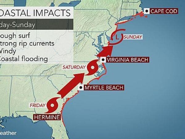
The National Weather Service issued its newest advisory and updated details on what we can expect from Hermine. BREAKING

The National Weather Service Friday afternoon issued a "Tropical Storm Watch" for the immediate Shoreline including New Canaan, Darien, Greenwich and Stamford.
The weather service states that this means tropical storm wind conditions are possible within the next 48 hours.
The weather service says gusts up to 35 mph are likely but some gusts between 39 and 57 mph are a "reasonable threat" and could lead to some power outages and destruction of property.
Concerning storm surge, the weather service states, that life-threatening storm surge is possible and there is the potential for 2 to 4 feet above ground somewhere within surge prone areas. The window of concern begins Saturday evening.
The weather service said people living along the immediate water should have emergency plans developed including evacuation plans if needed. The weather service says now is the time to formulate plans.
Get free real-time news alerts from the Milford Patch.
SUBSCRIBE
"Leave if evacuation orders are given for your area. Consider voluntary evacuation if recommended. Poor decisions may needlessly risk lives," the weather service states.
The weather service says that major beach erosion with heavy surf may breach dunes creating very dangerous surf and rip currents.
We can also expect periods of heavy rain and about an inch of rain during the peak of the storm Sunday and Monday, the weather service states. Some minor flooding is possible.
Rain is expected to begin after 8 p.m. Sunday and continue through most of Labor Day and possibly into Tuesday.
Image via Accuweather
Get more local news delivered straight to your inbox. Sign up for free Patch newsletters and alerts.