Community Corner
'Crippling and Potentially Historic Blizzard' Takes Aim at New London
The National Weather Service is advising residents not to travel from Monday evening into Tuesday.

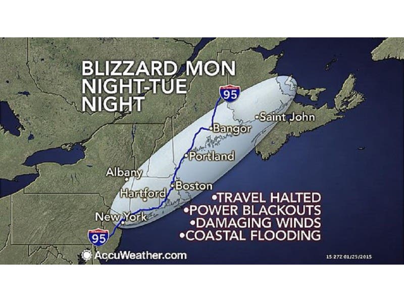
Calling it a “crippling and potentially historic blizzard,” the National Weather Service is advising against traveling from Monday evening through Tuesday because of a blizzard that could dump up to 33 inches of snow on New London.
The NWS replaced its blizzard watch with a blizzard warning and a coastal flood flood for the area was issued.
NWS Forecast
Find out what's happening in New Londonfor free with the latest updates from Patch.
- Sunday Night: Increasing clouds, with a low around 18. Wind chill values between 10 and 15. Northwest wind 6 to 9 mph becoming northeast after midnight.
- Monday: A slight chance of snow before 9 a.m., then widespread blowing snow and a chance of snow between 9 a.m. and 3 p.m., then snow likely with widespread blowing snow after 3 p.m. Cloudy, with a high near 29. Wind chill values between 5 and 15. Blustery, with a northeast wind 11 to 21 mph, with gusts as high as 31 mph. Chance of precipitation is 70%. New snow accumulation of 1 to 3 inches possible.
- Monday Night: Snow with widespread blowing snow. The snow could be heavy at times. Some thunder is also possible. Low around 20. Wind chill values between zero and 10. Very windy, with a north wind 25 to 30 mph increasing to 35 to 40 mph after midnight. Winds could gust as high as 55 mph. Chance of precipitation is 100%. New snow accumulation of 12 to 18 inches possible.
- Tuesday: Snow with widespread blowing snow. The snow could be heavy at times. Some thunder is also possible. High near 24. Wind chill values between zero and 5. Windy, with a north wind 36 to 39 mph, with gusts as high as 55 mph. Chance of precipitation is 100%. New snow accumulation of 8 to 12 inches possible.
- Tuesday Night: Snow with widespread blowing snow before 9 p.m., then snow likely with widespread blowing snow between 9 p.m. and midnight, then widespread blowing snow and a chance of snow after midnight. Low around 13. Windy, with a northwest wind 29 to 34 mph decreasing to 18 to 23 mph after midnight. Winds could gust as high as 47 mph. Chance of precipitation is 90%. New snow accumulation of 1 to 3 inches possible.
- Wednesday: A slight chance of snow before 9 a.m. Partly sunny, with a high near 26. Chance of precipitation is 20%.
Vincent Salzo contributed to this report. Photo Credit: Accuweather.com
Find out what's happening in New Londonfor free with the latest updates from Patch.
Get more local news delivered straight to your inbox. Sign up for free Patch newsletters and alerts.