Home & Garden
North Haven Storm: What's In Store for Sunday?
As North Haven digs out of Saturday's major snowstorm, there is some good news on the horizon.

By Brian McCready
Of course we would go from largely no snow this winter season to a blizzard all at once.
And let’s be honest, no one saw this coming. Yes, a snowstorm had been forecast for this weekend, possibly, for several days now, but no one was forecasting a blizzard or a near blizzard.
Find out what's happening in North Havenfor free with the latest updates from Patch.
As we wake up Sunday morning, the Blizzard/Winter Storm warnings end and we’re hopefully using the snow blower and not shoveling this stuff.
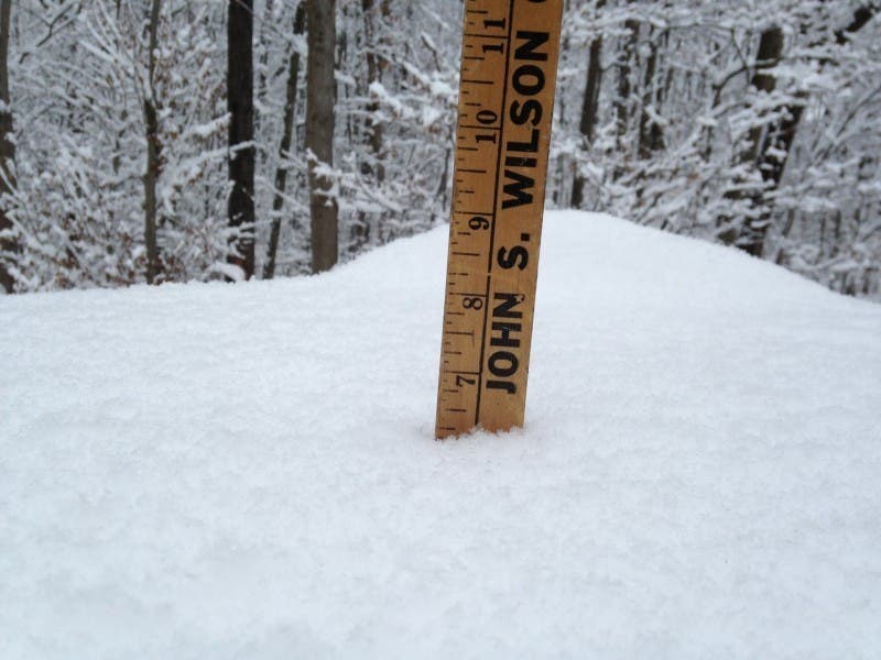
Depending on where you are in Fairfield, New Haven, Middlesex, and New London counties you’re looking at about a foot of snow on the low end, and possibly 2 feet of snow.
Find out what's happening in North Havenfor free with the latest updates from Patch.
Unlike last winter, when we got hit with a blizzard, another snowstorm was on its way two days later, we’re facing a much better situation.
Sunday will be dry, which is a good thing, and temps will be around the freezing mark and clouds will turn to sunny skies.
But after Sunday, we’ll see a slow warm-up as temps will be above freezing through Saturday, and most importantly no snow chances through Saturday.
We may even hit the mid-40s on Tuesday!
UPDATE, 4:45 p.m.
The National Weather Service has just issued a “Special Weather Statement” for all of Fairfield, New Haven, Middlesex, and New London counties.
The Blizzard Warning remains in effect for southern Fairfield, New Haven, Middlesex, and New London counties for between 1-2 feet of snow. The areas with 2 feet of snow will be west of Bridgeport, the National Weather Service writes.
Northern Fairfield, New Haven, Middlesex, and New London counties continue to operate under a Winter Storm Warning for between 10-14 inches of snow.
Here is the latest Special Weather Statement issued by the National Weather Service late Saturday afternoon:
Heavy snow is moving into southern Connecticut now and snowfall rates of 1-2 inches per hour are expected.
Some snowfall rates of up to 3 inches per hour are possible in isolated incidents.
The heaviest snow for southern Connecticut is expected between 5-7 p.m. with blizzard conditions continuing at the immediate coast, and near blizzard conditions a bit inland.
By Brian McCready
How high can they go! Yesterday, we were looking at maybe a few inches of snow, emphasis on maybe, and those totals have been increased significantly, and now they’ve just exploded again.
The National Weather Service says we can now expect between 10-14 inches of snow in northern Fairfield and northern New Haven counties.
- See related story: Blizzard 2016: Snowfall Totals in Connecticut (So Far)
The Winter Storm Warning remains in effect until 7 a.m. Sunday.
* HAZARD TYPES...HEAVY SNOW AND NEAR BLIZZARD CONDITIONS.
* ACCUMULATIONS...SNOW ACCUMULATION OF 10 TO 14 INCHES.
* WINDS...NORTH 15 TO 25 MPH WITH GUSTS UP TO 45 MPH.
* TEMPERATURES...IN THE MID 20S.
* TIMING...THROUGH TONIGHT.
* IMPACTS...HAZARDOUS TRAVEL DUE TO REDUCED VISIBILITIES AND SIGNIFICANT SNOW ACCUMULATIONS. BLOWING AND DRIFTING OF SNOW WITH NEAR BLIZZARD CONDITIONS ARE EXPECTED DUE TO STRONG WINDS.
*Get the latest on the storm in real time and North Haven news. Sign up for our daily newsletter and news alerts. News Alerts, Facebook
Get more local news delivered straight to your inbox. Sign up for free Patch newsletters and alerts.