Weather
Tropical Storm Watch Now Issued for Norwalk
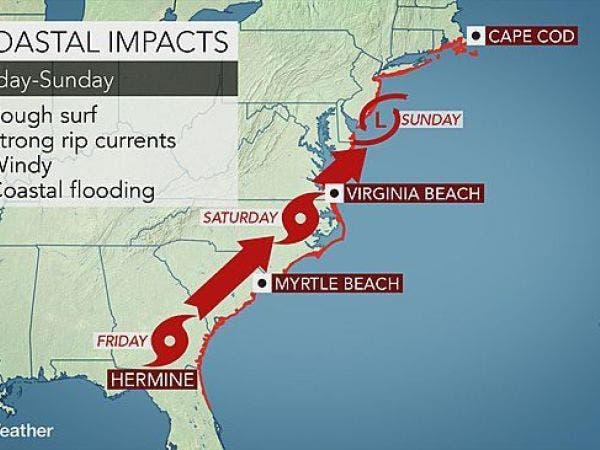
The National Weather Service issued its newest advisory and updated details on what we can expect from Hermine. BREAKING

The National Weather Service Friday afternoon issued a "Tropical Storm Watch" for the immediate Shoreline including Norwalk, Westport, Milford, Branford, North Branford, Guilford, and Madison.
The weather service states that this means tropical storm wind conditions are possible within the next 48 hours.
The weather service says gusts up to 35 mph are likely but some gusts between 39 and 57 mph are a "reasonable threat" and could lead to some power outages and destruction of property.
Find out what's happening in Norwalkfor free with the latest updates from Patch.
Concerning storm surge, the weather service states, that life-threatening storm surge is possible and there is the potential for 2 to 4 feet above ground somewhere within surge prone areas. The window of concern begins Saturday evening.
The weather service said people living along the immediate water should have emergency plans developed including evacuation plans if needed. The weather service says now is the time to formulate plans.
Find out what's happening in Norwalkfor free with the latest updates from Patch.
"Leave if evacuation orders are given for your area. Consider voluntary evacuation if recommended. Poor decisions may needlessly risk lives," the weather service states.
The weather service says that major beach erosion with heavy surf may breach dunes creating very dangerous surf and rip currents.
"Norwalk officials are] closely monitoring the progress of Hermine and making preparations as this storm moves towards the area. The City’s Emergency Management Team met this morning to discuss the potential impact in Norwalk and remain in contact over the weekend. In addition to the City’s website and social media sites, the Code Red system may be used to update residents. To register for notifications/ emergency alerts, visit www.norwalkct.org and follow the links to the Code Red page.
The following are some storm-related tips from the Norwalk Fire Department:
- Prepare your evacuation plan, including pets, transportation routes and destinations.
- Keep all trees and shrubs well trimmed and clear loose and clogged rain gutters and downspouts.
- Stay informed! Listen to a NOAA weather radio or check local forecasts and news reports regularly.
- Bring in all outside furniture, decorations, garbage cans, etc.
- Turn off propane tanks.
- Fill the bathtub or buckets with water to use for cleaning and flushing toilets, if directed to do so.
- Keep your gas tank at least 3/4 full at all times.
- Keep cell phones and other mobile devices charged. Remember, text messages can often go even if cell phone calls can’t.
- Keep your emergency supplies kit, including water, and copies of important documents, in a waterproof, portable container, in an easily accessible location.
- If your basement may flood, move items off the floor and check sump pumps to ensure they’re functioning properly.
- For additional safety tips, visit www.ready.gov or http://www.flash.org/hurricanestrong/
- For social media updates, Like us on Facebook – NorwalkOEM or follow us on Twitter @Norwalk_OEM.
Connecticut can also expect periods of heavy rain and about an inch of rain during the peak of the storm Sunday and Monday, the weather service states. Some minor flooding is possible.
Rain is expected to begin after 8 p.m. Sunday and continue through most of Labor Day and possibly into Tuesday.
Photo credit: AccuWeather.com
Get more local news delivered straight to your inbox. Sign up for free Patch newsletters and alerts.