Weather
Connecticut Weather Forecast for Labor Day: Latest Update on How Hermine May Impact Plans
If you're planning an outdoor picnic or barbecue today, here's the latest on the Labor Day forecast and what impact Hermine may have.

Just a few days ago it appeared the impacts of Hermine could ruin Labor Day plans statewide in Connecticut. We were looking then at a forecast that might feature periods of heavy rain, tropical storm winds, and possible flooding concerns.
Well things are a lot different now. Yes, a Tropical Storm Warning is still in effect for some parts of the Connecticut coastline in New Haven, Middlesex and New London counties. The Tropical Storm Warning has been dropped for coastal Fairfield County communities.
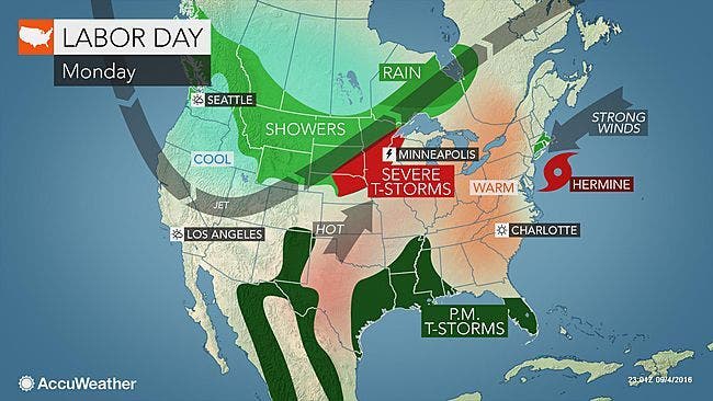
The National Weather Service and Connecticut meteorologists agree that Connecticut, especially areas along the coast and southeastern Connecticut will see some impacts from Hermine on Labor Day. The impacts will largely be gusty winds, but the strength of the wind is also going to be a lot less than was originally feared.
Find out what's happening in Norwalkfor free with the latest updates from Patch.
Gusts at the shore may be in the 30-35 mph range this afternoon and much less inland. Also most of the state will remain dry except for southeastern Connecticut, which could see periods of rain later on Labor Day.
WTNH News 8 Meteorologist Gil Simmons said, “Labor Day More clouds expected today with high temperatures in the 70s. The winds will pick up a little bit more for the afternoon with gusts 30 to 35 mph. Scattered showers possible for eastern Connecticut but most areas will stay dry. I do expect some wind tomorrow and a few scattered showers as the storm comes a little bit closer. Hot weather for the end of the week!”
Find out what's happening in Norwalkfor free with the latest updates from Patch.
Connecticut could see temps in the 90s by the end of the week. Summer is not over yet!
It’s clear that Hermine’s path definitely changed and so did the impact on the state. NBC Connecticut Meteorologist Ryan Hanrahan said Sunday on his Facebook page that “Hermine continues moving offshore... Well east of what our models expected. Will be doing a lot of post mortem thinking about what went wrong but while the storm moves away... Definitely a busted forecast by me.”
Hanrahan was clearly not alone as every meteorologist including the National Weather Service was predicting Connecticut would see much greater impacts from Hermine last week.
See also: Craving a Lobster Roll? These Spots Offer the Best in Connecticut
Detailed look at the Labor Day forecast in Connecticut:
Southern Connecticut:
Labor Day: Mostly cloudy, temps near 80 degrees. Breezy with a north wind of 14 to 22 mph and gusts up to 33 mph.
Monday night: Slight chance of rain after midnight and winds around 20 mph.
Tuesday: 30 percent chance of rain after 2 p.m. Winds still gusty, possibly up to 30 mph.
Wednesday: Sun may return, temp around 80 degrees. Reduced winds.
Hartford and Tolland counties:
Labor Day: What Hermine impact? Partly sunny skies with temps near 76 and a wind between 9-16 mph.
Monday night: Mostly cloudy, and a wind around 11 mph.
Tuesday: Chance for a morning shower and then partly sunny skies and a high near 80.
Wednesday: Sunshine, high near 84.
And then the heat and sun returns for Connecticut at the end of the week and into the weekend.
Photo credit: Accuweather.com
Get more local news delivered straight to your inbox. Sign up for free Patch newsletters and alerts.