Weather
NoVa Weather: Snow Could Cause Hazardous Morning Commute
Northern VA has two chances for snow this week with the first on Wednesday morning, plus bitter cold arriving for the New Year's weekend.


WASHINGTON, DC — Two chances for snow loom in the seven-day forecast for Washington, D.C., and northern Virginia, and bitterly cold temperatures are expected - particularly in the overnight hours, when it could plunge to as low as 17 degrees - just in time for the next holiday weekend. Forecasts call for New Year's Eve is supposed to be as cold as 29 degrees, with a low in the teens that night.
On top of that, there are two chances of snow to give Virginia drivers some travel headaches heading into New Year's Eve weekend. Snow could fall on Tuesday night and Wednesday, says the National Weather Service. There remains a large amount of uncertainty in the forecast, so the NWS is currently pegging the odds of snow at 20 to 30 percent for those days.
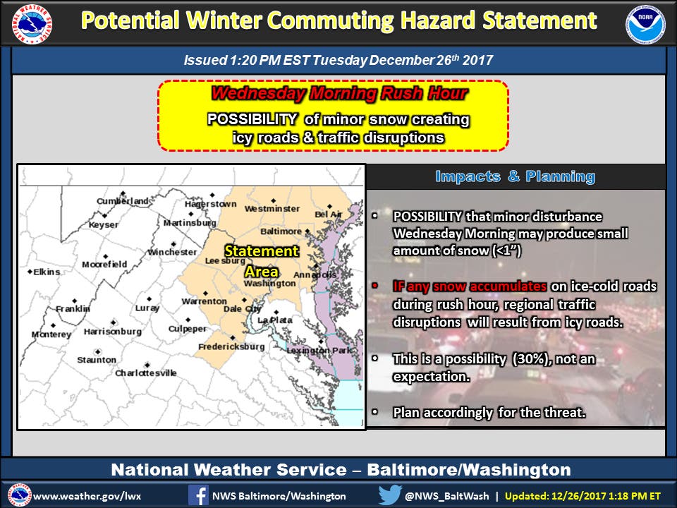
Tuesday afternoon the National Weather Service warned of a potential winter commuting hazard for the Baltimore-Washington, D.C. region on Wednesday morning. A period of snow is possible from 4 to 10 a.m. across the Baltimore/Washington metro region with less than an inch accumulation likely on area roads.
Find out what's happening in Washington DCfor free with the latest updates from Patch.
If the snow falls during Wednesday morning's rush-hour, many roads could quickly turn icy. "This could lead to dangerous traveling conditions, multiple accidents, and extensive delays," the NWS says. "If commuting Wednesday morning, be aware of the possibility of significant travel disruptions. Plan ahead by allowing for extra travel time, and consider using public transportation and telework options."
Along with cities of Baltimore and Washington, DC. areas included in the weather advisory are Prince William, Manassas, Manassas Park, Fairfax, Arlington, Falls Church, Alexandria, Stafford, Spotsylvania, Fauquier, Loudoun, Dale City, Manassas, Woodbridge, Lake Ridge, Montclair, Reston, Herndon, Annandale, Centreville, Chantilly, McLean, Franconia, Arlington, Alexandria, Falmouth, Fredericksburg, Warrenton, Turnbull, Purcellville, Leesburg, Ashburn, and Sterling.
Find out what's happening in Washington DCfor free with the latest updates from Patch.
The arctic cold wave gripping the central and eastern United States for the final week of 2017 is not expected to ease by the time tens of thousands of revelers celebrate New Year's Eve, according to AccuWeather.
"For those looking ahead to the New Year's holiday, the cold pattern that developed this week in the central and eastern part of the country is expected to persist for the remainder of 2017," AccuWeather Long-Range Meteorologist Max Vido said in a release.
The interaction between a storm in the South and a storm that will move across the Midwest will determine how the East Coast will be affected Friday into Saturday, according to AccuWeather. "The potential for a more substantial snowfall will be possible across the mid-Atlantic and Northeast if the northern storm links up with the southern storm," Vido said.
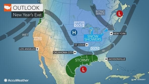
Lesser impacts are possible should the two storms fail to interact and the southern storm tracks eastward out to sea. However, a stronger interaction of the two could form a nor'easter along or just off the Atlantic coast.
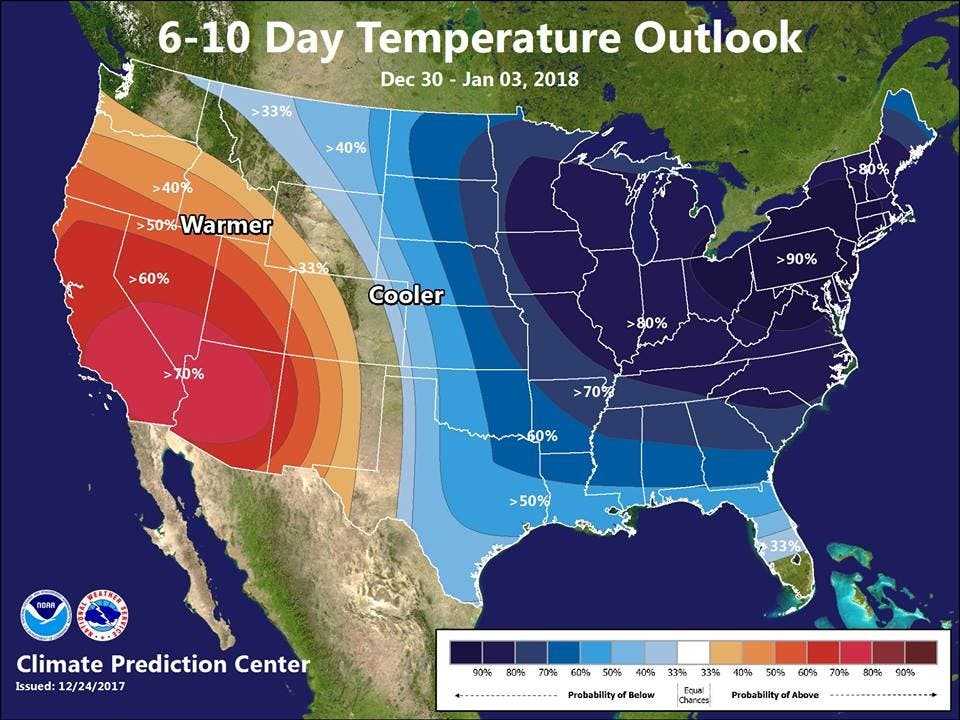
"2017 will be ending on a cold note -- and 2018 doesn't look to start out any warmer either! Some towns will remain below freezing for the rest of the year," the Baltimore-Washington staff of the weather service said on Facebook.
Here is the forecast:
Tuesday Night: A slight chance of snow showers after 4am. Increasing clouds, with a low around 25. Northwest wind around 6 mph. Chance of precipitation is 20%.
Wednesday: A chance of snow showers, mainly before 10am. Mostly cloudy, then gradually becoming sunny, with a high near 30. North wind 6 to 11 mph. Chance of precipitation is 30%.
Wednesday Night: Mostly clear, with a low around 16. Northwest wind 8 to 11 mph.
Thursday: Mostly sunny, with a high near 26. North wind 3 to 7 mph.
Thursday Night: Mostly cloudy, with a low around 20.
Friday: Partly sunny, with a high near 32.
Friday Night: Mostly cloudy, with a low around 23.
Saturday: Partly sunny, with a high near 32.
Saturday Night: Partly cloudy, with a low around 19.
Sunday: Mostly sunny, with a high near 29.
Sunday Night: Partly cloudy, with a low around 17.
New Year's Day: Mostly sunny, with a high near 28.
Image via Pixabay
Get more local news delivered straight to your inbox. Sign up for free Patch newsletters and alerts.