Weather
Fred Fizzles As Tropical Storm Grace Becomes Season's 7th Storm
The National Hurricane Center said there's a 90 percent chance that Fred could restrengthen into a tropical storm.

FLORIDA — After becoming disorganized overnight, Tropical Depression Fred has been downgraded to a tropical wave. But Florida residents shouldn't let down their guards yet. Tropical Storm Grace has formed in the Atlantic and is expected to impact Florida's west coast later this week.
Moreover, the National Hurricane Center said Fred should be completely counted out. There is a 90 percent chance of Fred restrengthening into a tropical storm in the next five days.
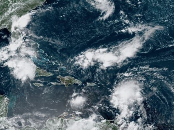
According to the hurricane center, the remnants of the storm Fred are moving west-northwest at 12 mph. Fred is expected to pass west of the lower Florida Keys Saturday afternoon and then turn northwest Saturday night. This will be followed by a northward motion Sunday night when Fred will have the chance to become more organized.
Find out what's happening in Miamifor free with the latest updates from Patch.
Stay tuned to Patch for tropical storm updates. Subscribe to your local Patch newsletter.
Meanwhile, at 11 a.m. Saturday, Tropical Storm Grace was about 265 miles east-southeast of the Leeward Islands with maximum sustained winds of 45 mph with higher gusts. The storm is moving west at 23 mph and has tropical storm-force winds that extend up to 35 miles from the center of the storm.
Find out what's happening in Miamifor free with the latest updates from Patch.
Grace is expected to turn west-northwest during the next several days, moving over the Leeward Islands Saturday night, over the Virgin Islands and Puerto Rico Sunday, over the Dominican Republic Monday and then move between the southeastern Bahamas and Cuba on Tuesday.
Some strengthening is forecast during the next day or so then Grace is likely to weaken while it moves near and across the Greater Antilles Sunday night through Monday night.
Floridians can expect a rainy week ahead due to both the remnants of Fred and Tropical Storm Grace.
Through Monday, 3 to 5 inches of rain is anticipated across the Keys and southern Florida and 3 to 7 inches are expects in the Florida Big Bend area and the Panhandle, causing minor to moderate flooding.
Some squalls and swells from Fred are possible Saturday across the Florida Keys and the southern portion of the Florida Peninsula and reach the coast of Alabama and the Florida Panhandle Monday.
Tropical Storm Grace will likely bring heavy rainfall to Florida by mid to late next week.
The National Oceanic and Atmospheric Administration is predicting a busier-than-average Atlantic hurricane center, which runs from June 1 to Nov. 30.
NOAA predicted 15 to 21 named storms, with seven to 10 becoming hurricanes.
Researchers from Colorado State University, who provide storm predictions for the season each April, revised their forecast on Aug. 5, have also predicted a busy storm season.
University researchers are now predicting 18 named storms, up from 17 in their April forecast, including the five named storms that have already occurred. They anticipate eight hurricanes, four of which will be Category 3 or higher.
This will make 2021 the sixth straight year of an above-average Atlantic hurricane season. The record 2020 season had 30 named storms, 12 of which made landfall, including Laura and Delta, which struck southwest Louisiana.
The increases are based on a lack of any El Niño conditions, which typically reduce Atlantic hurricane activity.

See related stories:
Get more local news delivered straight to your inbox. Sign up for free Patch newsletters and alerts.