Weather
Fred May Become Tropical Storm Friday; 2nd Tropical Storm Brewing
Following Fred, the National Hurricane Center said potential tropical cyclone 7 is expected to develop into a tropical storm on Saturday.


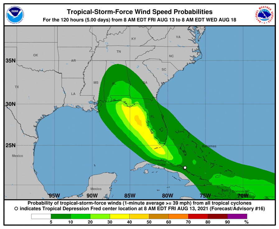
FLORIDA — Tropical Depression Fred is expected to strengthen into a tropical storm Friday as the storm continues moving west-northwest at about 12 mph, according to the National Hurricane Center. And another storm is close behind, possibly headed for Florida.
Forecasters are keeping a close eye on another weather disturbance forming in the Atlantic Ocean, Potential Tropical Cyclone 7. It is expected to become a tropical depression Friday night and a tropical storm Saturday.
Fred is currently located off the northeast coast of Cuba, about 410 miles southeast of the mouth of Tampa Bay. The storm is expected to turn to the northwest Friday night or Saturday morning.
Find out what's happening in Tampafor free with the latest updates from Patch.
A tropical storm warning is now in effect for the Florida Keys west of Ocean Reef to the Dry Tortugas and Florida Bay, and a tropical storm watch has been issued for coastal Charlotte and Lee counties.
A tropical storm warning means tropical storm conditions are expected within 36 hours.
Find out what's happening in Tampafor free with the latest updates from Patch.
Additional watches and warnings will likely be issued later Friday, said hurricane center forecasters.
Stay tuned to Patch for updates on Tropical Depression Fred. Subscribe to your local Patch newsletter.
On the forecast track, Fred is expected to move along or just north of eastern and central Cuba through Friday night and be near the Florida Keys on Saturday and the west coast of Florida on Sunday.
The last pass by the Air Force Hurricane Hunter aircraft several hours ago indicated that maximum sustained winds are near 35 mph with higher gusts. A slow strengthening is expected during the next couple of days as Fred speeds up to about 20 mph.
The National Oceanic and Atmospheric Administration and Air Force Hurricane
Hunter aircraft will fly into Fred again Friday to assess the storm's intensity and structure.
From Friday into Monday, 3 to 7 inches of rain is anticipated across the Keys, southern and central Florida north toward the Big Bend, with isolated maximum totals of 10 inches.
Tropical storm conditions are expected across the Florida Keys on Saturday and swells could reach the Keys and southern Florida by early Saturday and increase along the west coast of Florida Saturday night and Sunday.
The risk of tropical storm conditions will spread northward along the Florida west coast and to the
Florida Panhandle Sunday and Monday.
The National Weather Service said residents should prepare for flooding across West Central and Southwest Florida. Some streets and parking lots take on moving water as storm drains and retention ponds overflow, causing hazardous driving conditions. There's a possibility of road and bridge closures.
As Fred moves northward just off the coast, the threat for tropical storm force winds, localized flash flooding, hazardous marine conditions and perhaps tornadoes is possible.
Some communities may see isolated tornadoes, causing damage to roofs, snapping branches off and uprooting trees and pulling boats from their moorings. They may also cause power outages and communications disruptions.
Heavy surf and storm surge may cause additional flooding in coastal areas, damage marinas, docks and piers, cause moderate beach erosion and create strong rip currents that make swimming dangerous.
Wind gusts across West Central and Southwest Florida may damage porches, awnings, carports, sheds, mobile homes and blow lightweight objects around.
Cities and counties from the Keys to Tampa Bay have begun opening sandbag stations and activating emergency operation centers in anticipation of Fred's arrival.
The NWS said now is the time for residents to check their emergency plans and emergency supplies kits.
Tropical storm watches have been issued for a portion of the Leeward Islands.
This disturbance is moving west at 21 mph with maximum sustained winds of 35 mph. On the forecast track, the system is expected to approach the Leeward Islands on Saturday, move over the Leeward Islands Saturday night and Sunday, and then be near the Virgin Islands and Puerto Rico Sunday night and Monday.
See related stories:
- Tropical Depression Fred Expected To Strengthen Near Florida
- Tropical Storm Fred Expected To Affect Florida Starting Friday
- Above-Normal 2021 Atlantic Hurricane Season Predicted By NOAA
- Hurricane Season's 1st Atlantic Tropical Storm Possibly Forming
- 2021 Hurricane Season Names: From Ana And Bill To Sam And Wanda
Get more local news delivered straight to your inbox. Sign up for free Patch newsletters and alerts.