Weather
Tropical Storm Cristobal Forms In The Atlantic: See FL Impacts
Tropical Storm Cristobal formed in the Atlantic Wednesday, with two more systems being watched for tropical development, forecasters said.


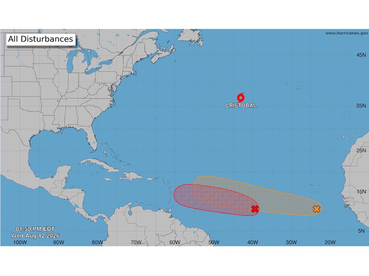
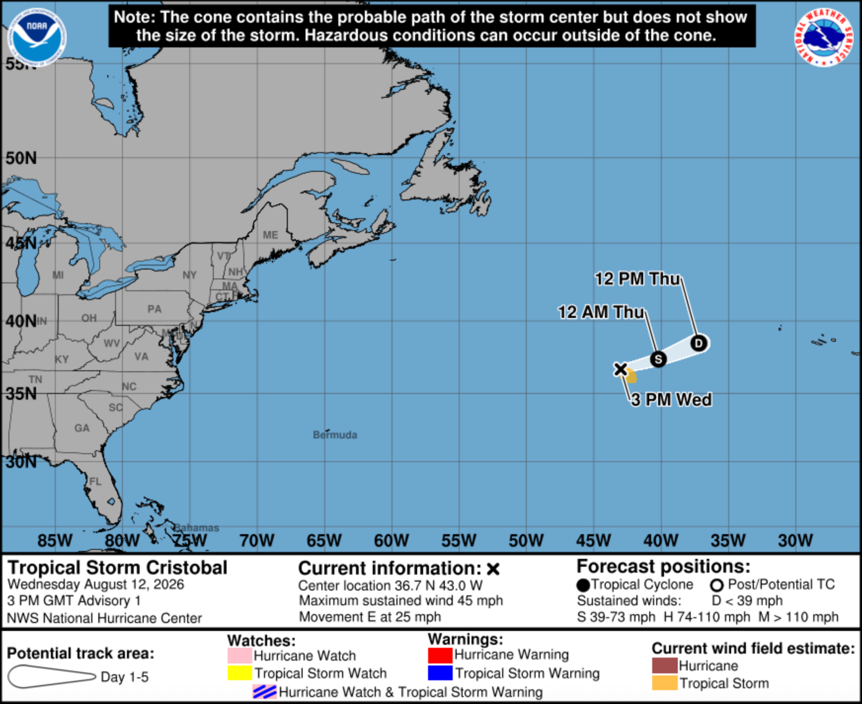
Tropical Storm Cristobal, the third named storm of the 2026 Atlantic hurricane season, formed Wednesday afternoon, the National Hurricane Center said.
The system strengthened as forecasters are eyeing two more areas in the Atlantic for possible tropical development.
Cristobal, located northeast of Bermuda, is heading east across the ocean, away from the U.S., at 25 mph, the NHC said.
Find out what's happening in Tampafor free with the latest updates from Patch.
The system is recording maximum sustained winds of 45 mph, with some higher gusts, the agency said. Tropical-storm-force winds are extended about 90 miles from the center.
The storm is expected to lose steam shortly, according to NHC meteorologists. “Slow
Find out what's happening in Tampafor free with the latest updates from Patch.
weakening is forecast … [later Wednesday] as the storm moves over
progressively cooler waters and encounters increasingly dry
mid-level air and stronger northerly wind shear. Cristobal is
expected to be short-lived and dissipate on Thursday.”
As it moves away from the U.S., there’s a remote chance it could merge with another front, bringing rain to parts of Ireland and the United Kingdom early next week, AccuWeather forecasters said.
Meanwhile, Invest 92-L could strengthen into the season’s fourth named tropical storm, Dolly.
Invest 92-L, an area of showers and thunderstorms associated with a tropical wave, is about 950 miles west-southwest of the Cabo Verde Islands, as of Wednesday afternoon, the NHC said.
This system has an 80 percent chance of strengthening into a tropical depression over the next two days, the agency said.
“Environmental conditions are forecast to be conducive for development during the next couple of days, and a tropical depression will likely form while the system moves westward to west-northwestward across the central tropical Atlantic,” according to the NHC.
The system “is currently in a zone that is generally favorable for development this week,” AccuWeather lead hurricane expert Alex DaSilva said, adding that it will most likely develop from Wednesday through Friday.
Fox forecasters said 92-L will “track in the general direction of the northeast Caribbean for the next few days.”
As it moves toward the Caribbean, the invest will encounter dry Saharan dust and hostile upper-level winds, which could prevent it from strengthening much, experts said.
“However, it still has a slight chance of developing into a low-end tropical storm,” Fox said.
The system’s strength will determine its path, according to AccuWeather.
If the wave doesn’t develop or at most is a tropical depression or weak tropical storm, it is expected to move toward the Leeward and northern Windward Islands this weekend, the agency said.
Should the system organize quickly, developing into a stronger tropical storm and then a hurricane, it is likely to turn north of the Leeward Islands, AccuWeather said. If its strengthening is delayed, then it could track near or over the islands.
If the wave stays poorly organized and survives any wind shear it encounters in the Caribbean, it could move toward the coast of Central America early next week, AccuWeather said.
The system could bring low tropical rain and wind impacts to the U.S. Gulf Coast, including Florida, by the weekend, forecasts said.
Trailing behind 92-L is a new tropical wave just off the coast of west Africa.
This area is producing disorganized showers Wednesday and has a 20 percent chance of developing over the next two days and a 40 percent chance of formation in the next week, the NHC said.
“Environmental conditions are forecast to be generally conducive for some development of this system during the next several days while it moves westward or west-northwestward across the eastern and central tropical Atlantic,” the NHC said.
See Also:
- Odds Increase For Tropical Depression In Atlantic: See FL Forecast
- NOAA Lowers 2026 Hurricane Forecast As Peak Season Nears
- 5 Things To Know About The 2026 Atlantic Hurricane Season
- 2026 Atlantic Hurricane Names: What Storms Will Be Called This Season
- 'Super El Niño' Could Form In Atlantic: What It Means For FL Hurricane Season
Get more local news delivered straight to your inbox. Sign up for free Patch newsletters and alerts.