Weather
FL Could See Tropical Cyclone Develop From Trough In Gulf: NOAA
With two of the hottest months on record, weather forecasters predict global warming will result in stronger hurricanes hitting Florida.

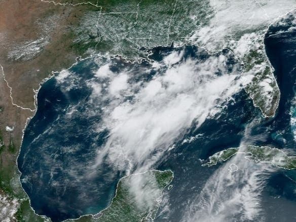
FLORIDA — A broad trough of low pressure over the northern Gulf of Mexico has a chance of developing into a tropical cyclone later this week if it remains offshore, according to a statement issued by the National Hurricane Center in Miami at 2 p.m. Monday.
The trough is now producing a large area of disorganized showers and thunderstorms, the NHC said. If it can remain away from land as it meanders near the coast in the Gulf of Mexico, it has a 10 percent chance of developing into a tropical storm in the next 48 hours and a 30 percent of becoming a tropical storm in the next five days.
Regardless of how it develops throughout the week, NHC hurricane specialist Philippe Papin said heavy rains will be possible along portions of the northern Gulf coast from Louisiana to the Florida Panhandle over the next several days.
Find out what's happening in Tampafor free with the latest updates from Patch.
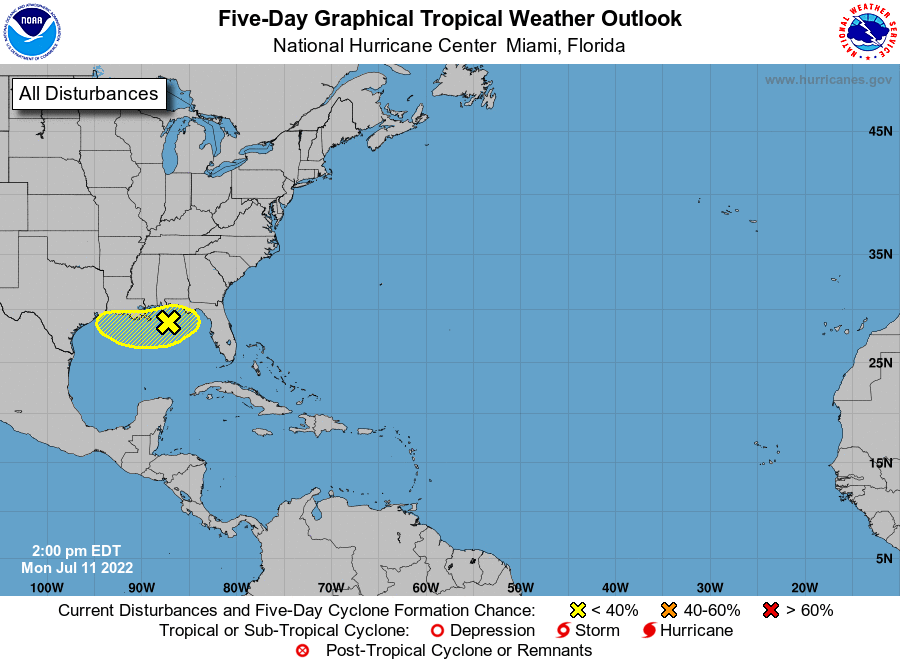
The trough has a 10 percent chance of developing into a tropical storm in the next 48 hours and a 30 percent of becoming a tropical storm in the next five days.
Rainfall will increase as the circulation from the buddingtropical system begins to pump more moisture northward from the Gulf of Mexico, AccuWeather.com said. A general 4-8 inches of rain will fall along the central Gulf Coast region even if the tropical system fails to form due to its slow-moving nature.
Cities such as Biloxi, Mississippi; Mobile, Alabama; and Pensacola, Florida; should be prepared for downpours capable of causing flash flooding, AccuWeather said.
Find out what's happening in Tampafor free with the latest updates from Patch.
So far, the busy hurricane activity predicted for the 2022 Atlantic hurricane season has yet to materialize. However, residents shouldn't let down their guard yet, said Kenneth Graham, the former director of the NHC who became the National Oceanic and Atmosphere Administration assistant director for weather services and the 17th director of the National Weather Service last month.
Forecasters at NOAA’s Climate Prediction Center, a division of the National Weather Service, are predicting above-average hurricane activity this year, which would make it the seventh consecutive above-average hurricane season, Graham said during a webinar previewing the hurricane season.
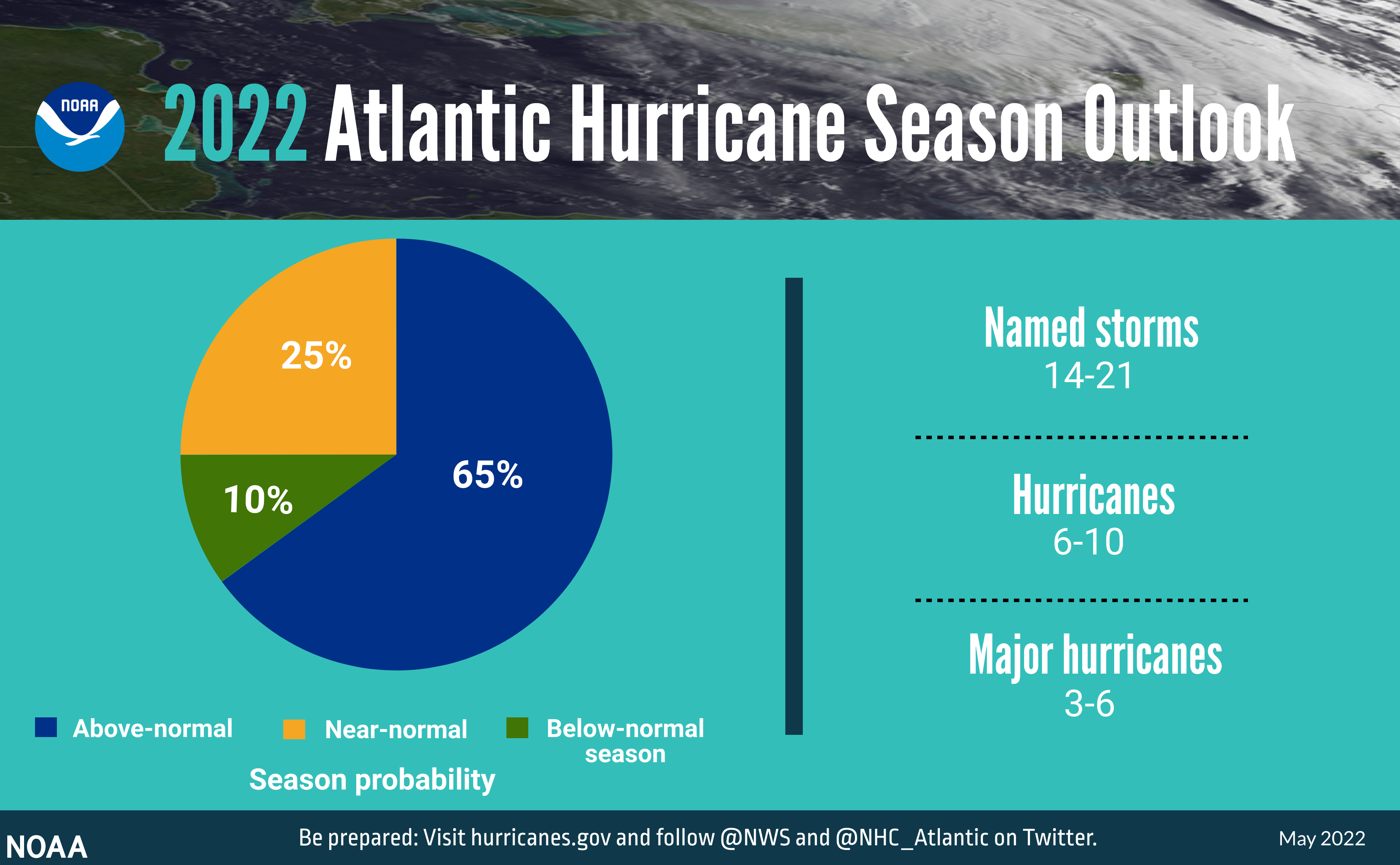
NOAA’s outlook for the 2022 Atlantic hurricane season, which runs from June 1 to Nov. 30, predicts a 65 percent chance of an above-normal season, a 25 percent chance of a near-normal season and a 10 percent chance of a below-normal season.
See related stories:
- 2022 Hurricane Names List Released For Atlantic Season
- Above-Normal 2021 Atlantic Hurricane Season Predicted By NOAA
With 70 percent confidence, NOAA is forecasting 14 to 21 named storms (with winds of 39 mph or higher), of which six to 10 could become hurricanes (with winds of 74 mph or higher), including three to six major hurricanes (Category 3, 4 or 5, with winds of 111 mph or higher).
The increased activity anticipated this hurricane season is attributed to several climate factors, including the ongoing La Niña that is likely to persist throughout the hurricane season, warmer-than-average sea surface temperatures in the Atlantic Ocean and Caribbean Sea, weaker tropical Atlantic trade winds and an enhanced west African monsoon, Graham said. An enhanced west African monsoon supports stronger African easterly waves, which seed many of the strongest and longest lived hurricanes during most seasons.
Graham said NOAA scientists are now studying the way climate change impacts the strength and frequency of tropical cyclones. Since hurricanes form over relatively warm sea surfaces, Graham said it's reasonable to conclude that global warming will greatly increase hurricane activity around the world.
Evaporation intensifies as temperatures rise, and so does the transfer of heat from the oceans to the air. As the storms travel across warm oceans, they pull in more water vapor and heat. That means stronger winds, heavier rainfall and more flooding when the storms hit land.
Evan Thompson, president of the World Meteorological Organization's Regional Association for North America, Central American and the Caribbean, agrees.
He said the recently released Sixth Assessment Report by the WMO's Intergovernmental Panel on Climate Change concluded "the global proportion of tropical cyclones that reach very intense (Category 4 and 5) levels, along with their peak winds and rainfall rates, are expected to increase with climate warming," Thompson said. "Developing countries and small islands are on the front lines. Accurate early warnings are no longer a luxury, but a must."
He said higher sea temperatures are exacerbated by rising sea levels caused by melting glaciers.
The average global sea level has already risen by half a foot since 1900 — nearly 4 of those inches since 1970 — as countries have developed and populations have grown.
Higher sea levels push more water inland during hurricane-related storm surges, resulting in more destructionhe said.
During NOAA's monthly teleconference with the media June 16, Karen Gleason, a climatologist with NOAA's national centers for environmental information, reported that May 2022 was the ninth-warmest May in 143 years.
Above-average warm temperatures dominated much of the nation in June as well, with Florida, Louisiana and Mississippi experiencing their top 10 warmest Junes on record, while Texas saw its fifth warmest on record.
Overall, the U.S. experienced its 15th warmest June in 128 years, and the period from January to May ranked as the sixth warmest period on record, according to NOAA.
To add more doom and gloom to the forecast, the six-month period from January through June ranks as the fifth highest for severe weather behind 2017, 2020, 2011 and 2021.
There were nine individual billion-dollar weather and climate events across the U.S. during this period, including:
- Three severe weather events.
- Two tornado outbreaks.
- Two hail storms.
- A derecho event.
- A broad drought event.
The costliest event so far this year was the severe storm and flash flooding that took place in Missouri and Arkansas between April 11-13. It cost an estimated $2.2 billion.
Since 1980, when NOAA began tracking these events in the U.S., the nation has sustained 332 separate weather and climate disasters where overall damages reached or exceeded $1 billion per event. The total cost of these 332 events exceeds $2.275 trillion.
NOAA researchers say the most damaging U.S. hurricanes are three times more frequent than 100 years ago, and the proportion of major hurricanes (Category 3 or above) in the Atlantic Ocean has doubled since 1980.
This all means that both local government and residents must plan ahead to protect life and property, Graham said.
NOAA Administrator Dr. Rick Spinrad said the WMO's Sixth Assessment Report leaves no doubt that policies of governments and the behavior of people have caused climate warming resulting in more destructive hurricanes.
"We must urgently reduce our emissions while also increasing our efforts to adapt to the impacts we can no longer avoid," Spinrad said. "Simply put, societies and ecosystems need to prepare now for the increasing effects of extreme heat, drought, sea level rise and other impacts of climate change."
He urged governments to heed these warnings.
"It's our goal to engage even more elected officials and business leaders in using NOAA's data, products and services so that they can create climate plans of their own," he said. "As NOAA's administrator, it is my goal to ensure that our agency is helping these decision makers build a climate-ready nation that strengthens our resilience to climate change, which will help protect lives, lifestyles and livelihoods."
The National Hurricane Center has provided a series of documents in both English and Spanish to help residents prepare:
Get more local news delivered straight to your inbox. Sign up for free Patch newsletters and alerts.