Weather
Potential Cyclone Inches Toward Florida Coast, Warnings Issued
A tropical storm warning was in place Friday for FL southern coast by the National Hurricane Center, with a foot of rain possible in areas.


Updated at 6:30 p.m. Friday
TAMPA, FL — A potential tropical cyclone continued late Friday to inch its way closer to Florida, but has not yet developed the speed or strength needed to earn the designation of Tropical Storm Alex.
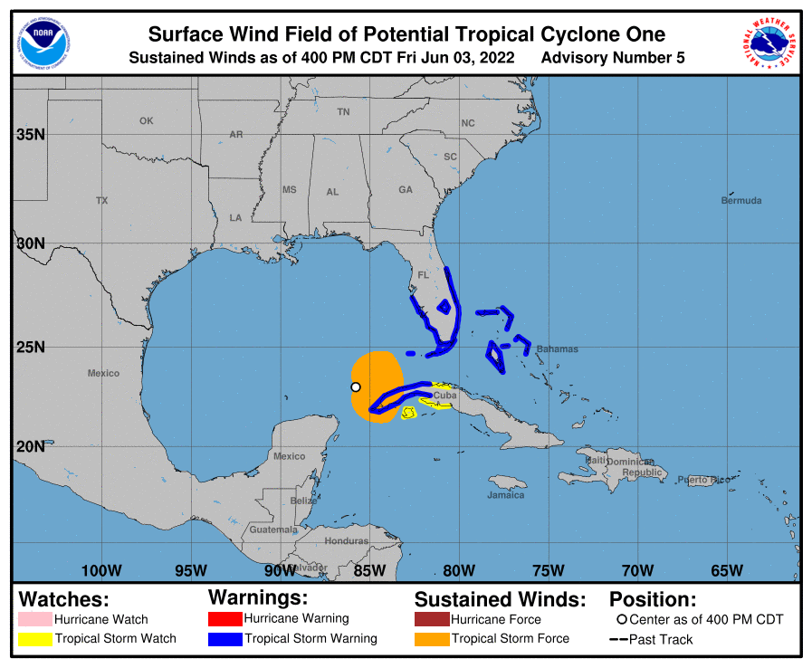
A hurricane hunter aircraft reported the storm is now located 350 miles southwest of Fort Myers, has a 90 percent chance of developing a well-defined center and becoming a tropical storm Friday night, according to the National Hurricane Center. The storm has maximum sustained winds of 40 miles per hour.
Find out what's happening in Tampafor free with the latest updates from Patch.
Data from the aircraft shows there should be some slight strengthening in the storm as it approaches Florida Saturday. It is moving southeast across the Gulf of Mexico at a bit faster pace than earlier today — about 7 mph — producing maximum sustained winds near 40 mph with higher gusts that extend 70 miles from the center of the storm, according to the NHC.
The hurricane hunters confirmed the storm is on a forecast track to move across the southeast Gulf of Mexico through Friday night, across southern and central Florida on Saturday, and then head over the southwest Atlantic Saturday afternoon through Sunday.
Find out what's happening in Tampafor free with the latest updates from Patch.
"But that's not the story," NHC Director Ken Graham said. "The real story is all the moisture that's headed toward Florida. That's going to be one of the biggest impacts."
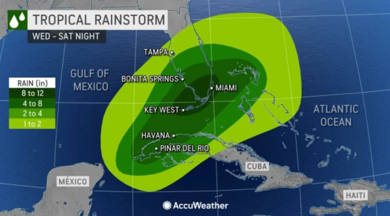
He said southwest portions of Florida will receive 6 to 10 inches of rain.
"I would not be shocked if some places get 12 inches of rain," he said. "That's significant. And who knows where those rain bands are going to be? That's going to cause some urban flooding so best to be off the roads tonight and tomorrow to be safe."
Graham said Floridians will feel the effects of the storm whether it's upgrade to full tropical storm status or not.
"It could have a name. It might not have a name. Either way, you're still going to get that rain," he said. "If we do have a name, Alex will be the name, and we do think the winds will be 40 to 45 mph by the time it makes it to Florida, so we do have tropical storm warnings up. And the arrival of those tropical storm-force winds are going to arrive tonight or early Saturday morning, about 2 a.m."
He said the winds will arrive along the southwest coast of Florida and then spread across the entire peninsula on Saturday.
"So tonight and tomorrow will be the main focus of some of these impacts," Graham said.
A tropical storm warning has been issued along the west coast of Florida south of Longboat Key to Englewood. This includes Manatee, Polk, Sarasota, Hardee, Desoto and Highlands counties.
There is also a tropical storm warning in effect along the east coast of Florida south of the Volusia and Brevard County lines to Card Sound Bridge, including Lake Okeechobee, Graham said.
A tropical storm warning was issued Thursday night for the Straits of Florida with seas producing waves of 6 to 8 feet, and remains in effect.
A tropical storm warning means that tropical storm conditions are expected within 36 hours, and severe and potentially dangerous weather is imminent.
A tropical storm watch means that tropical storm conditions are possible within 48 hours.
With all the rain that's predicted, Graham said the risk of flash flooding in south Florida are in the moderate risk zone from Okeechobee south.
"We could get 2 to 3 inches of rainfall in an hour with some of these rain bands so you gotta keep yourself safe," he said. "Most of the fatalities from tropical systems are from water. A lot of that is from inland flooding and about half of those are in automobiles."
The other major danger, he said, is storm surge.
"It doesn't have to be a big hurricane to get storm surge," Graham said. "In this case we're seeing 1 to 3 feet from Marco Island down to the Keys and 1 to 2 feet in Miami Beach and up to Longboat Key (on the west coast)."
Graham is also warning boaters to stay off the water. There are areas around the Keys that could see 15-foot waves.
"Those 15-foot waves are incredibly dangerous, especially for a small craft," he said.
The system is forecast to move across the southeastern Gulf of Mexico through Friday night, across the southern and central portions of the Florida Peninsula on Saturday, and then over the southwestern Atlantic north of the Bahamas Saturday afternoon through Sunday, said NHC Director Ken Graham.
Additional strengthening is possible after the system moves east of Florida over the western Atlantic late Saturday and Sunday. It has a 90 percent chance of formation during the next 48 hours and during the next five days, said NHC meteorologists.
Central Florida, South Florida and the Florida Keys can expect 4 to 8 inches of rain with a maximum of 12 inches across South Florida and in the Keys. This rain may produce considerable flash and urban flooding and a few tornadoes are possible, said the NHC.
AccuWeather.com meteorologists are reporting a nearly identical assessment of the storm, saying 8 to 12 inches of rainfall is possible from the Florida Keys to the Everglades and the Miami area on Saturday night.
"The rain will be beneficial in some South Florida communities due to abnormally dry to drought conditions that have unfolded this spring," AccuWeather said. "However, too much rain will fall in many locations and is likely to cause flooding in urban and low-lying areas. Forecasters say motorists and pedestrians should be prepared to take alternative routes in locations that are prone to flooding during times of heavy rain."
The combination of storm surge and the tide will cause normally dry areas near the coast to be flooded by rising waters moving inland from the shoreline, said AccuWeather forecasters.
As the storm swings northeastward over the Atlantic later this weekend and into the middle of next week, AccuWeather concurs with the NHC that there is the potential for strengthening to a strong tropical storm.
Get more local news delivered straight to your inbox. Sign up for free Patch newsletters and alerts.