Weather
South Florida Flooding As Potential Tropical Storm Crosses State
Potential Tropical Cyclone 1 is moving across south Florida Saturday, with a tropical storm warning issued for the state's east coast.

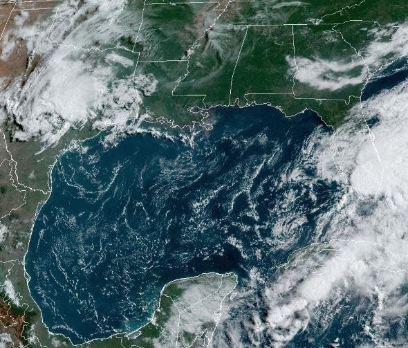

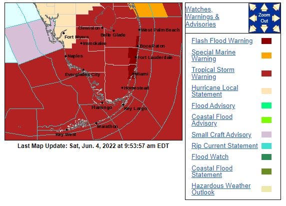
FLORIDA — A potential tropical cyclone is moving across south Florida Saturday, causing flash flooding in the Miami area that prompted authorities to ask people to stay off the streets. A tropical storm warning has been issued for the east coast of Florida south of the Volusia/Brevard County Line to Card Sound Bridge.
Heavy rains led to flooding in parts of Miami, where AccuWeather’s Bill Wadell reported roadways were flooded with “waist-deep” water at one point. People struggled to get out of their cars, which resulted in many climbing through their sunroofs to escape from their cars.
At its 11 a.m. update, National Hurricane Center meteorologists said the storm is located 60 miles northeast of Naples and about 100 miles southwest of Vero Beach on Florida's east coast as it moves across the state at about 18 mph with sustained winds of 40 mph.
Find out what's happening in Tampafor free with the latest updates from Patch.
The latest update from the NHC brings some good new for some Floridians. The tropical storm warning has been discontinued for the west coast of Florida, north of Bonita Beach. That puts communities along the west coast from Fort Myers north out of the immediate hazard zone.
Early Saturday, Miami’s fire and rescue team urged people to clear the roads as they were out in their high water vehicles answering calls for help from standard drivers, AccuWeather reported.
Find out what's happening in Tampafor free with the latest updates from Patch.
Mario Robleto, a Miami resident who was working an overnight shift came out to see his car submerged in water.
“I just came to mine and I just see the whole water inside my car and I didn’t turn it on because I knew it wasn’t going to work,” Robleto said. A drone shot from Saturday morning showed the roadways still covered in water and cars scattered along the roads.
But by 10 a.m., Wadell reported the conditions in downtown Miami had improved significantly. In efforts to remove the remaining water from the roadways, one person was seen clearing the storm drains with their hands since drains were covered with leaves, debris and trash.
See related stories:
- Potential Cyclone Inches Toward Florida Coast, Warnings Issued
- Rip Current Flag Warnings Flying; Not Good Day For Beach
A tropical storm warning is in effect for the east coast of Florida south of the Volusia/Brevard County Line to Card Sound Bridge and the northwestern Bahamas. A tropical storm watch is in effect for Bermuda.
A tropical storm warning means that tropical storm conditions are expected somewhere within the next 24 hours. A tropical storm watch means that tropical storm conditions are possible somewhere within the watch area.
The storm is expected to continue hammering south Florida with heavy rains through Saturday. The forecast track by NHC meteorologists and AccuWeather forecasters show the disturbance is expected to move across southern or central Florida Saturday and then into the Atlantic Ocean Saturday night, where it is expected to become Tropical Storm Alex.
Earlier this morning, a weather station at Government Cut near Miami reported a wind gust of 53 mph.
On Friday, NHC Director Ken Graham said the rain remains the biggest concern.
"The real story is all the moisture that's headed toward Florida. That's going to be one of the biggest impacts," he said. "I would not be shocked if some places get 12 inches of rain. That's significant. And who knows where those rain bands are going to be? That's going to cause some urban flooding, so best to be off the roads."
The storm is still expected to produce 6 to 10 inches of rain with some isolated areas of south Florida receiving up to 15 inches, said AccuWeather.com forecasters Saturday morning. With the rain comes a considerable danger of flash and urban flooding.
The combination of storm surge and the tide will cause normally dry areas near the coast to be flooded by rising waters moving inland from the shoreline, the NHC said, with water levels of 1 to 3 feet above normal tide levels.
A couple of tornadoes are possible over southern Florida and the upper Keys through early Saturday afternoon.
Stay tuned to Patch for updates throughout the day. Send your weather photos to D'Ann Lawrence White at dann.white@patch.com to be included in the Patch weather updates.
Get more local news delivered straight to your inbox. Sign up for free Patch newsletters and alerts.