Weather
Tropical Storm Dolly Forms In The Atlantic
The fourth named storm of the 2026 Atlantic hurricane season, Tropical Storm Dolly, has formed, the National Hurricane Center said.


Updated: Thursday, 11:25 a.m.
Tropical Storm Dolly, the fourth named storm of the 2026 Atlantic hurricane season, formed Thursday morning, National Hurricane Center forecasters said.
The name is a coincidence following Tuesday’s death of country music legend and humanitarian Dolly Parton. Atlantic storm names are determined years in advance.
Find out what's happening in Tampafor free with the latest updates from Patch.
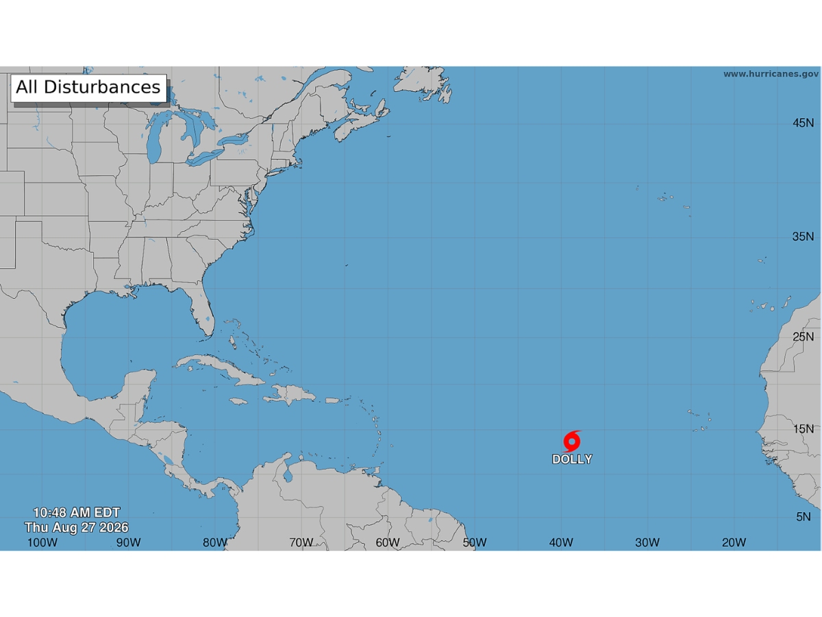
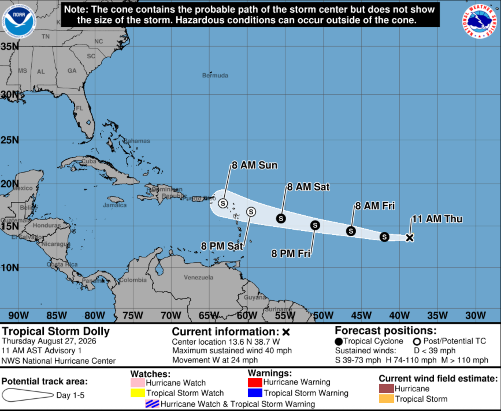
The storm, which formed over the central tropical Atlantic, about halfway between Africa and the Windward Islands, has maximum sustained winds of 40 mph as of Thursday around 11 a.m.
Tropical Storm-force winds extend up to 60 miles from the system’s center.
Find out what's happening in Tampafor free with the latest updates from Patch.
Dolly is expected to move west across the Atlantic at about 24 mph over the next couple of days and should near the Leeward Islands this weekend, the NHC said.
Though “interests in the Leeward Islands should monitor” the system, it isn’t expected to strengthen over the next several days, the agency said.
“Dolly is forecast to degenerate into a tropical wave before it reaches the Leeward Islands,” NHC forecasters said.
The storm could still bring heavy rains, producing flash flooding, to the Leeward Islands late Saturday into Monday, experts said. It could affect the Virgin Islands, Puerto Rico and Hispaniola on Sunday and Monday, the NHC said.
Forecasters have been eyeing the area since the weekend, though its chances of developing lowered briefly overnight Tuesday and on Wednesday.
The odds of it developing into a named storm then increased again overnight Thursday, though it's expected to fizzle out.
“Environmental conditions are expected to become hostile beginning on Friday, likely ending its chances for further development,” the NHC said.
AccuWeather’s lead hurricane expert Alex DaSilva said of the system, “There is a window for development through the end of the week before the tropical rainstorm encounters stronger wind shear near the Leeward Islands. People in the Lesser Antilles should closely monitor this tropical wave, which is expected to approach the Leeward Islands this weekend with downpours and gusty squalls.”
Denis Phillips, chief meteorologist with Tampa Bay 28, said advisories should be expected later Thursday, but there’s nothing to worry about in Florida.
“This system is still not a major threat or a concern as it will run into a lot of shear before it gets to the islands,” he wrote in a social media post.
Fox 35 meteorologist Noah Bergren also said he isn’t worried about this system.
“I'm not worried about it yet. Will tell you when to be. Otherwise, not a concern at this time,” he wrote in a social media post. “However, the trend has been for this to track weaker and further south, which is what would need to happen for it to survive through the hostile region of El Nino caused wind shear.”
Meteorologists are monitoring the system as they continue to lower their forecasts for the 2026 hurricane season.
AccuWeather last week changed its forecast to eight to 11 named storms, three to four hurricanes and one to two major hurricanes this year.
Earlier this month, the National Oceanic and Atmospheric Administration also lowered its seasonal forecast.
NOAA reduced its forecast to seven to 13 named storms, two to six hurricanes and zero to two major hurricanes. The agency also increased the probability of a below-normal season from 55 percent in its May outlook to 75 percent.
Both forecasts point to El Niño as a major reason for the expected slowdown.
The climate pattern develops in the Pacific but can influence weather patterns around the globe. In the Atlantic, El Niño typically increases vertical wind shear, making it more difficult for tropical systems to organize and strengthen.
So far, the Atlantic has been unusually quiet as hurricane season’s climatological peak approaches. Just three tropical storms — Arthur, Bertha and Cristobal — had formed as of Aug. 19, with activity running behind several historical benchmarks.
“The area around [Florida], the Bahamas, and SW Atlantic is one of the only places in the entire Atlantic Ocean basin that is somewhat favorable for tropical development right now this year,” Bergren wrote.
Fox’s forecasting model is calling for “a weak tropical wave north of Puerto Rico next Monday,” he added. “From there it could either die off entirely or survive long enough to get to a point where it could become something more meaningful. For now, we will sit and wait.”
See Also:
- Forecasters Continue To Lower Hurricane Season Predictions As Peak Season Nears
- NOAA Lowers 2026 Hurricane Forecast As Peak Season Nears
- 5 Things To Know About The 2026 Atlantic Hurricane Season
- 'Super El Niño' Could Form In Atlantic: What It Means For FL Hurricane Season
- 2026 Atlantic Hurricane Names: What Storms Will Be Called This Season
Get more local news delivered straight to your inbox. Sign up for free Patch newsletters and alerts.