Weather
Tropical Storm Fiona Expected To Reach Hurricane Strength Sunday Night
By early next week, Fiona is expected to reach the Bahamas, just 110 miles from the Southeast Florida coast, said forecasters.


TAMPA, FL — Tropical Storm Fiona is showing some muscle as she makes her way into the Caribbean Sea, where she is expected to reach near hurricane strength as she travels northeast, the National Hurricane Center said Friday.
The hurricane center has issued storm warnings for Puerto Rico and the U.S. Virgin Islands, and advised Floridians living on the southeast coast to brace for impacts as Fiona nears the southeastern Bahamas, just 110 miles east of Miami, early next week.
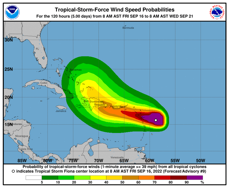
According to NHC forecaster Robbie Berg, Air Force Reserve and NOAA Hurricane Hunters have been flying through Fiona during the past several hours. They report that Fiona is about 135 miles from Guadeloupe where she's whipping up 12-foot seas and has sustained winds of 50 mph extending 140 miles from the storm's center.
Find out what's happening in Tampafor free with the latest updates from Patch.
Moving west at about 14 mph, Fiona is expected to strengthen in the next few days and bring tropical storm conditions to some popular Caribbean cruise ports of call in the next 36 hours, including Antigua, St. Kitts, Montserrat, St. Martin as well as Puerto Rico and the U.S. Virgin Islands.
Heavy rains from Fiona will reach the Leeward Islands by Friday night, spreading to the British and U.S. Virgin Islands and Puerto Rico Saturday, the Dominican Republic on Sunday and the Turks and Caicos Monday night or Tuesday morning.
Find out what's happening in Tampafor free with the latest updates from Patch.
From there, Fiona is expected to reach near hurricane strength as she travels over the northeastern Caribbean Sea and approaches the southern coast of the Dominican Republic Sunday night and early Monday, according to the 11 a.m. update from the NHC.
No tropical storm watches or warnings have been issued for Florida at this time.
A tropical storm warning means tropical storm conditions are expected within the next 36 hours and a stropical storm watch means tropical storm conditions are possible within 48 hours.
Fiona is the fifth named storm of the 2022 hurricane season, which has been uneventful so far.
If Fiona becomes a hurricane, it would be only the third of the 2022 Atlantic season. Hurricane Danielle peaked at hurricane intensity twice over the open waters of the North Atlantic in early September. Earl was the second tropical storm to strengthen into hurricane force. It reached Category 2 strength over the central Atlantic in early September, AccuWeather reported.
"There will likely be significant disruptive wind shear in this area at times, but as the system moves along in the same general direction as the shear, its negative impacts could be diminished and that can allow Fiona to strengthen," AccuWeather Senior Meteorologist Bob Smerbeck said.
From there, Fiona will grow stronger after moving across Hispaniola early next week and heads to the Turks and Caicos Islands and the southeastern Bahamas early next week.
The National Weather Service said this weekend could bring hazardous weather conditions to much of South Florida with heavy rains, lightning strikes and gusty winds possible along with localized flooding, scattered to numerous thunderstorms, lightning strikes, gusty winds and a risk of rip currents Friday along the beaches of Palm Beach County. The weather service said a few waterspouts are possible over coastal waters Friday as well.
The weather service has issued a hazardous weather outlook for the Atlantic coast in Southeast Florida, Biscayne Bay, the Gulf of Mexico and Lake Okeechobee starting Friday.
This thunderstorm activity in south Florida is expected to continue Saturday through Thursday, peaking during the afternoon and early evening each day. Gusty winds, frequent lightning and localized flooding may accompany thunderstorms.

RELATED STORIES:
- Hurricane Season 2022 Predicted To Be 'Above Normal': NOAA
- 2022 Hurricane Names List Released For Atlantic Season
Forecasters at the National Oceanic Atmospheric Administration's Climate Prediction Center said in their annual prediction for the 2022 Atlantic hurricane season, which runs June 1 to Nov. 30, that the season should be active.
According to this year's forecast, the ongoing La Niña, in addition to above-average ocean temperatures, means there's a 65 percent chance the 2022 hurricane season will be above normal.
For the 2022 season, forecasters are predicting 14 to 21 named storms with winds of 39 mph or higher. Of those, anywhere from six to 10 of the storms could become hurricanes with winds of 74 mph or higher.
This year's season could also spawn anywhere from three to six major hurricanes rated a category 3 or higher, forecasters said.
So far, the predictions haven't panned out, but the most active part of the hurricane season is still to come during the months of September, October and November.
Get more local news delivered straight to your inbox. Sign up for free Patch newsletters and alerts.