Weather
Zeta Becomes Hurricane With Maximum Winds Of 80 mph
The storm has sustained winds near 80 mph, qualifying Zeta as a hurricane. Epsilon has been downgraded and is no longer a threat to the U.S.

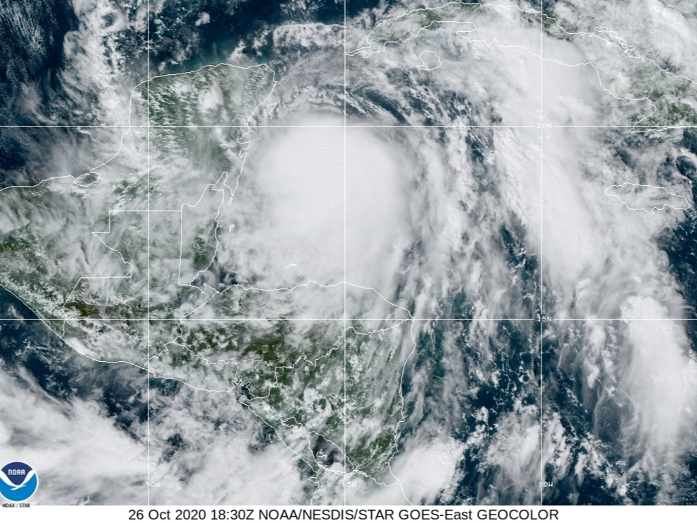

MIAMI, FL — Air Force Reserve hurricane hunters flew into Zeta on Monday afternoon and determined the storm has maximum sustained winds near 80 mph with higher gusts, qualifying it as a hurricane.
Zeta was 90 miles southeast of Cozumel, Mexico, moving northwest at 10 mph.
Hurricane Zeta is expected to bring hurricane conditions and a dangerous storm surge to portions of the Yucatan Peninsula, and a storm surge watch was issued for the north Gulf Coast of the U.S.
Find out what's happening in Tampafor free with the latest updates from Patch.
Overnight, however, Hurricane Episilon lost some of her luster. Recent satellite-derived wind data indicate that Epsilon no longer has the structure of a tropical cyclone. Furthermore, infrared cloud tops have warmed over the past several hours as convection wanes near the center, forecasters said. Therefore, Epsilon has been declared a post-tropical cyclone, and the last National Hurricane Center advisory was issued for the system.
A storm surge watch is in effect from Intracoastal City, Louisiana, to Navarre, Florida, including Lake Borgne, Lake Pontchartrain, Vermilion Bay, Pensacola Bay and Mobile Bay. A storm surge watch means there is the possibility of life-threatening inundation from rising water moving inland from the coastline during the next 48 hours.
Find out what's happening in Tampafor free with the latest updates from Patch.
A hurricane watch is in effect from Morgan City, Louisiana, to the Mississippi/Alabama border, including Lake Pontchartrain, Lake Maurepas and metropolitan New Orleans. A hurricane watch means that hurricane conditions are possible within the watch area. A watch is typically issued 48 hours before the anticipated first occurrence of tropical storm-force winds that make outside preparations difficult or dangerous.
A tropical storm watch is in effect from the Mississippi/Alabama border to the Okaloosa/Walton County Line, Florida, and from west of Morgan City to Intracoastal City. A tropical storm watch means that tropical storm conditions are possible within the watch area, generally within 48 hours.
Zeta is expected to continue on a northwestward motion with some increase in forward speed over the next day or so, followed by a turn toward the north Tuesday night.
A faster northward to north-northeastward motion is forecast for Wednesday.
On the forecast track, the center of Zeta will move over the northern Yucatan Peninsula later Monday or Monday night, move over the southern Gulf of Mexico on Tuesday, and approach the northern Gulf Coast in the watch area on Wednesday.
Hurricane-force winds extend outward up to 25 miles from the center, and tropical storm-force winds extend outward up to 115 miles.
The waters could reach the following heights above ground somewhere in the indicated areas if
the peak surge occurs at during high tide:
- Port Fourchon, Louisiana, to Dauphin Island, Alabama, including Lake Borgne, 4-6 feet.
- Intracoastal City to Port Fourchon including Vermilion Bay, 2-4 feet.
- Dauphin Island to Navarre including Mobile Bay and Pensacola Bay, 2-4 feet.
- Lake Pontchartrain, 2-4 feet.
- Navarre to Yankeetown, Florida, including Choctawhatchee Bay and Saint Andrew Bay, 1-3 feet.
Rainfall totals of 4 to 8 inches with local amounts of 12 inches are possible through Tuesday along and east-northeast of Zeta's track across the Yucatan Peninsula of Mexico, the Cayman
Islands and central to western Cuba.
An initial area of heavy rains is expected to begin to impact the central Gulf Coast on Tuesday night, spreading north into the Tennessee Valley on Wednesday. The core of the heavy rains associated with Zeta will push northeast from eastern Louisiana across southern Mississippi, Alabama and northern Georgia through Wednesday night, and through the southern Appalachians into the Mid-Atlantic on Thursday.
Rainfall totals of 2 to 4 inches, with isolated amounts of 6 inches, are expected across these areas. These would result in flash, urban, small stream and minor river flooding.
Hurricane conditions are possible within the hurricane watch area on the northern Gulf Coast late Wednesday, and tropical storm conditions are possible within the tropical storm watch area on the northern Gulf Coast late Wednesday.
Related stories:
Get more local news delivered straight to your inbox. Sign up for free Patch newsletters and alerts.