Weather
Heavy Rain From Thunderstorms To Bring Flash Flooding To Atlanta Metro
A line of strong thunderstorms that hit north Georgia on Tuesday have left many at risk of flash flooding and a possible tornado.

NORTH GEORGIA — Flash flooding is possible in parts of the Atlanta metro as thunderstorms move across north and central Georgia Tuesday, along with the potential for a tornado threat in south Georgia.
The National Weather Service issued a flash flood warning through Tuesday night for portions of north and central Georgia, including southern Cherokee County, northern Clayton County, Cobb County, DeKalb County, northeastern Douglas County, Fulton County, and central Gwinnett County.
Shortly before 3 p.m., Doppler radar determined that between 1.5-3 inches of rain have fallen in north Georgia on Tuesday. Additional rainfall amounts of 0.2-0.5 inches are possible in the areas above. Flash flooding is ongoing or expected to begin shortly.
Find out what's happening in Across Georgiafor free with the latest updates from Patch.
Some locations that will see flash flooding include Atlanta, Marietta, Douglasville, Lawrenceville, Canton, Decatur, Jonesboro, Sandy Springs, Roswell, Johns Creek, Alpharetta,
Smyrna, Dunwoody, East Point, Milton, Kennesaw, Duluth, Woodstock, Acworth and Forest Park.
A flood warning has also been issued for Proctor Creek near Atlanta affecting Fulton County, Peachtree Creek near Atlanta affecting DeKalb and Fulton counties, Big Creek in Alpharetta, and Crooked Creek near Norcross.
Find out what's happening in Across Georgiafor free with the latest updates from Patch.
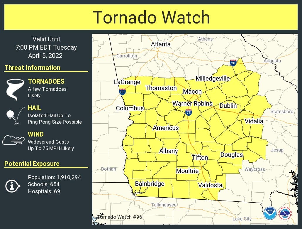
A tornado watch has also been issued for parts of Georgia until 7 p.m. Tuesday, mostly south of Macon.
Widespread showers and thunderstorms will spread across north and central Georgia Tuesday morning and will linger into the evening.
The thunderstorms may have lightning, gusty winds and heavy rainfall. The primary severe hazard will be large hail during the morning hours. This afternoon, the main threat would be damaging wind gusts up to 60 mph. A tornado or two are also possible.
The storms will also increase the risk for flooding and flash flooding of creeks and streams.
More showers and scattered thunderstorms will move through the area on Wednesday afternoon.
Some storms may become strong to severe, and capable of producing damaging wind gusts and large hail. A brief tornado or two are possible. Flooding and flash flooding is possible, especially in areas that received heavy rainfall on Tuesday.
Forecast for the remaining week in metro Atlanta
Tuesday
Showers and thunderstorms likely, then showers and possibly a thunderstorm after noon. Some of the storms could produce heavy rainfall. High near 68. Southeast wind 5 to 10 mph, with gusts as high as 25 mph. Chance of precipitation is 100 percent. New rainfall amounts between 1-2 inches possible.
Tuesday night
A 30 percent chance of showers and thunderstorms, mainly before 7 p.m. Mostly cloudy, with a low around 61. Southwest wind 5 to 10 mph, with gusts as high as 25 mph.
Wednesday
A 20 percent chance of showers and thunderstorms after 2 p.m. Mostly cloudy, with a high near 77. Southwest wind 5 to 10 mph, with gusts as high as 15 mph.
Wednesday night
Showers and thunderstorms likely, mainly between 9 p.m. and 3 a.m. Mostly cloudy, with a low around 52. South wind around 10 mph becoming west after midnight. Winds could gust as high as 20 mph. Chance of precipitation is 70 percent.
Thursday
A 30 percent chance of showers and thunderstorms before 9 a.m. Mostly sunny, with a high near 67. Northwest wind 10 to 15 mph, with gusts as high as 25 mph.
Thursday night
Mostly clear, with a low around 44.
Friday
Sunny, with a high near 58.
Friday night
Partly cloudy, with a low around 40.
Get more local news delivered straight to your inbox. Sign up for free Patch newsletters and alerts.