Weather
Winter Storm Watch Issued For Metro Atlanta: Updated Forecast
Forecasters said power outages in Georgia could last up to five days due to a winter storm that is expected to coat the region in ice.


Updated 1:12 p.m.
A winter storm watch has been expanded to include all of metro Atlanta and some surrounding counties ahead of a dangerous weekend system that could slam the Southeast.
The National Weather Service has issued the watch for the following counties: Fulton, Cobb, Gwinnett, Henry, DeKalb Rockdale, Douglas, Paulding, Clayton, Fayette, Coweta, Polk, Haralson, Carroll, Walton, Newton, Morgan, Greene, Taliaferro, Spalding, Butts, Jasper, Putnam, Hancock, Warren, Jones, Baldwin, Washington, Glascock and Jefferson.
Find out what's happening in Atlantafor free with the latest updates from Patch.
It will take effect at 1 p.m. Saturday and will expire at 10 a.m. Monday. The watch remains in place for north Georgia.
This comes after Gov. Brian Kemp on Thursday declared a state of emergency as Georgia hunkers down for what could be a massive, menacing winter storm this weekend.
Find out what's happening in Atlantafor free with the latest updates from Patch.
The storm is set to sweep much of Georgia and could come in the form of snow, sleet and/or freezing rain — triggering a winter storm watch and bringing warnings of power outages that could last for several days.
"There’s a lot of ingredients to line up to make this happen," said Laura Belanger, meteorologist with the National Weather Service's Peachtree City office.
This consists of a low-pressure system and how far north or south it tracks, she said. It will determine the coldness of Georgia at the surface level.
Kemp, during a Thursday morning press call from Belgium, said residents should be mindful of ice accumulation that could affect utility lines and travel.
Forecasters indicated Georgia's far north counties may see the most ice buildup.
Kemp acknowledged few uncertainties with the system, including a concrete path, but he said he ordered the state of emergency for impacted counties to ensure Georgia is prepared. The order will be in effect for at least a week.
Additionally, he authorized the use of 500 members of the National Guard, will activate the State Operations Center at 7 a.m. Saturday, and suspended the weight limit for trucks to ensure the delivery of fuel or other essential resources.
State officials urged people to ready themselves now by filling up gas tanks, gathering supplies and having all the necessities at home.
"We just want all of Georgia to be winter aware," Kemp said.
Forecasters on Thursday told Patch power outages could last for multiple days, and a delay in ice melting could make roads impassable and hinder crews from quickly restoring power.
Winter Storm Aims For Georgia
The timing of the system has adjusted slightly, with Kemp noting it could arrive a little later than expected on Saturday.
Belanger told Patch some weather models favor the onset of wintry precipitation to be between 8 p.m. and 10 p.m. Saturday across north Georgia. However, several other models indicate the storm could appear between 5 p.m. and 8 p.m.
The system could stretch into Sunday morning, with far northeast Georgia being of main concern for the NWS. Ice accumulations throughout Sunday in this specific region will be a "slam dunk," Belanger said.
While Kemp said the storm is primarily expected to hit north of Interstate 20, there is a possibility it could shift and slam Middle Georgia. Near-freezing temperatures could be the path's determining factor, with Kemp saying it only takes "a degree or two."
As of late, he said the most impacted areas may include those around GA-400 and north of the City of Atlanta, the Interstate 85 corridor heading toward Athens and Gainesville and other towns near Georgia's border with South Carolina.
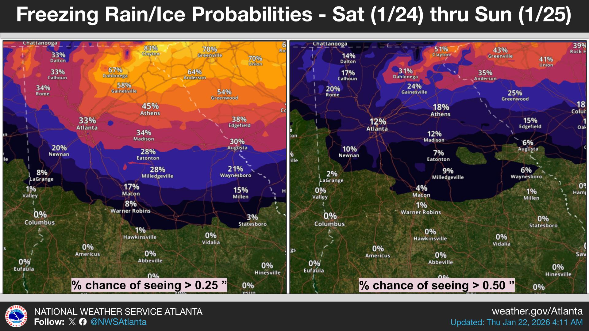
A National Weather Service graphic on Thursday showed the Atlanta area currently has a 33 percent chance of ice forming, while the City of Clayton has an 83 percent probability, on Saturday through Sunday.
"Major impacts in the watch area, including travel disruptions and power outages," the weather service stated.
Belanger said models show the system leaving Sunday evening and into Monday morning, but impacts could linger for several days.
The most significant forecast changes could be in Fayettee, Douglas and Coweta counties. There, it could be no ice or impactful ice accumulations, Belanger said.
Ice could freeze up to a quarter of an inch in Athens, Gainesville and the northeast mountains.
However, Belanger said areas near the mountains could potentially see three-quarters of an inch of ice during a "major, high-impact event." It may take up to five days to restore power in the mountains.
"People in that area should be planning to stay where they are or have no power longer than a day," she said.
Gwinnett, Forsyth, Cherokee and North Fulton counties could see ice accumulations of two-tenths of an inch, possibly 0.4 inches. In these counties, Belanger said power outages could last up to three days.
Melting may be slow due to below-freezing temperatures. Belanger said temperatures may rest in the 20s in metro Atlanta and in the teens in areas further north Monday morning.
As of Thursday, she said Atlanta may see a high temperature of 22 degrees, though the forecast still has time to drop to a few degrees cooler.
By Monday afternoon, expected temperatures in several metro counties are hovering around 33-35 degrees.
The coldest night in Georgia will be Monday night into Tuesday, with an anticipated high of 15 degrees. Belanger said temperatures could further plummet to 10 degrees.
Dalton, Blairsville and Rome could feel single-digit temperatures come Tuesday morning.
But Tuesday is Georgia's best chance for "better improvement" and melting, Belanger said.
The Georgia Department of Transportation is "on point and ready to roll," Kemp said. He added GDOT will begin brining and treating roadways between midnight and early Saturday morning in areas north of I-20.
Other agencies on standby include the Georgia State Patrol and the Georgia Department of Agriculture.
Kemp said he has been in contact with Georgia Power, which has stated it is fully ready for the storm.
How You Can Prepare
"By being ready for the storm, Georgia can do their part in minimizing risks," Director Josh Lamb, of the Georgia Emergency Management and Homeland Security Agency, said.
He added preparation could aid recovery efforts and minimize the loss of life.
As bridges and overpasses are the first to freeze, Lamb suggested people carefully drive on them. He also advised people have emergency car kits that include ice scrapers, snacks, portable battery chargers and other crucial items.
Gutters should be cleaned, outdoor pipes should be covered and doors and windows should be sealed, Lamb said.
Residents may want to have enough nonperishable food and medication for at least three days in the case of power outages. Lamb also encouraged they have emergency preparedness plans and a safe way to heat homes that do not include the oven or having portable generators indoors.
Roswell Police spoke against panic buying, asking people to purchase only what is needed.
"Bottom line: don't panic. We've made it through these storms before, and we'll do it again. Your City of Roswell, Georgia Government team and first responders at the Roswell Police Departmentand Roswell Fire Department are ready to handle business, as always. Do YOUR part by staying informed, staying prepared, and staying home if the weather takes a turn this weekend," police said in a Facebook post published Wednesday.
With still quite a bit of time before the storm, Belanger advised people "don't wait too long" in making their preparations. Tips she provided included knowing where warm shelter locations are and notifying a family member or friend where you are staying if not at home.
"Once things get going, you’re not going to want to be venturing out," she said.
The Georgia Emergency Management and Homeland Security Agency offers tips for before and during winter weather.
Updates will be posted on the weather service's Twitter page, the weather service's Facebook page and its website.
Get more local news delivered straight to your inbox. Sign up for free Patch newsletters and alerts.