Weather
GA State Of Emergency Declared Ahead Of Bomb Cyclone: See Snowfall Totals, Timing
The Atlanta metro is under a winter storm warning starting Saturday and continuing into Sunday, according to the National Weather Service.

Up to two inches of snow could fall in the Atlanta metro this weekend when a rapidly intensifying coastal storm hits the state, according to the latest forecasts. Gov. Brian Kemp also declared a state of emergency ahead of the storm as snow combined with bitterly cold temperatures are expected to lead to widespread travel disruptions across Georgia.
This weekend's storm is forecast to develop in the Southeast on Friday, then rapidly strengthen along the Atlantic Coast into a bomb cyclone by Saturday, according to AccuWeather's latest forecast. As it intensifies, snow coverage and wind speeds will increase across most of Georgia.
A winter storm warning was issued Friday for part of the Atlanta metro, including Cherokee, Cobb, Fulton, DeKalb, Rockdale, Newton, Clayton, Henry, Butts, Jasper, Jones and Wilkinson counties. The warning goes into effect at 1 a.m. Saturday and continues until 1 a.m. Sunday, according to the National Weather Service.
Find out what's happening in Atlantafor free with the latest updates from Patch.
Heavy snow is expected in the warning area, with total accumulations of up to 2 inches and locally higher amounts possible. Winds could gust as high as 35 mph.
The highest snow totals are expected in eastern Georgia, where up to 5 inches could fall by Saturday night.
Find out what's happening in Atlantafor free with the latest updates from Patch.
.png)
Dangerous wind chill temperatures are also expected for most of north Georgia on Saturday, and across all of north and central Georgia Saturday night into Sunday, according to the state Department of Emergency Management. Wind chills will remain in the teens, and high temperatures will not get above freezing.
Very cold temperatures will help snow instantly stick to the ground, which could cause travel conditions to deteriorate rapidly.
An extreme cold warning is in effect for the Atlanta metro from 7 p.m. Saturday until 1 p.m. Sunday, according to the National Weather Service.
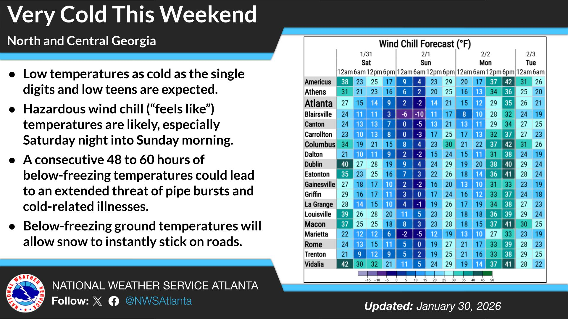
Dangerously cold wind chills ranging from as cold as 15 degrees below are expected in the north Georgia mountains, while central Georgia will see wind chills in the single digits above zero.
Gov. Brian Kemp on Friday declared a state of emergency, which allows the state to stage resources ahead of the storm.
"With back-to-back winter storms, we’re not taking any days off when it comes to keeping Georgians prepared and safe," Kemp said. "Those in affected areas should prepare now and stay off the roads as much as you can to give GDOT space to work."
Here's a look at the detailed National Weather Service forecast for the Atlanta region:
Friday: Partly sunny, with a high near 49. East wind around 5 mph becoming northwest.
Friday Night: A 10 percent chance of snow showers after 5am. Mostly cloudy, with a low around 22. Northwest wind 5 to 10 mph, with gusts as high as 20 mph.
Saturday: A 40 percent chance of snow showers, mainly before 1pm. Cloudy, with a high near 27. Northwest wind 15 to 20 mph, with gusts as high as 35 mph. New snow accumulation of less than one inch possible.
Saturday Night: Partly cloudy, with a low around 14. Wind chill values as low as -2. Northwest wind around 20 mph, with gusts as high as 35 mph.
Sunday: Sunny, with a high near 34. Northwest wind around 15 mph, with gusts as high as 30 mph.
Sunday Night: Partly cloudy, with a low around 21.
Monday: Sunny, with a high near 44.
Monday Night: Mostly clear, with a low around 28.
Tuesday: Partly sunny, with a high near 54.
Get more local news delivered straight to your inbox. Sign up for free Patch newsletters and alerts.