Weather
Tropical Storm Fred Expected To Bring Flash Flooding To GA
Nearly all of Georgia is under a flash flood watch through Wednesday due to Tropical Storm Fred, which may bring up to 5 inches of rain.


ATLANTA, GA — As Tropical Storm Fred continues to bear down on its path to the Gulf coast of Florida Monday, forecasters warn that the storm could lead to flash flooding in most of Georgia as up to 5 inches of rain is anticipated.
Nearly all of Georgia is under a flash flood watch through Wednesday due to Tropical Storm Fred. A hazardous weather outlook has also been issued for portions of north and central Georgia.
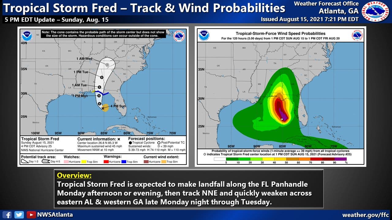
Monday afternoon, the tropical storm was located about 55 miles southwest of Apalachicola, Florida, and was intensifying. As of around 1 p.m., Fred was clocking sustained winds of nearly 60 mph as it moved north at about 10 mph, according to the National Weather Service.
Find out what's happening in Atlantafor free with the latest updates from Patch.
On the forecast track, the center of Fred should make landfall in the eastern Florida Panhandle Monday afternoon or early evening and move over western Georgia on Tuesday.
Some strengthening is possible before Fred makes landfall. After making land, Fred is expected to quickly weaken.
Find out what's happening in Atlantafor free with the latest updates from Patch.
Scattered to numerous showers and thunderstorms are expected Monday in Georgia. Tropical Storm Fred moves into the area late Monday night, bringing additional tropical rainfall.
A flash flood watch has also been issued for late Monday into Wednesday morning. Heavy rain and gusty winds will be the main hazards, although an isolated tornado cannot be ruled out, the National Weather Service said.
About 2-5 inches of rain is expected through the flash flood watch, with heavier amounts in some areas. Heavy rainfall on top of likely saturated soils will lead to flash flooding, the NWS said. As Fred moves through, additional bands of rainfall may cause training of storms through Wednesday morning that may exacerbate or lead to additional flash flood issues.
Tropical rainfall associated with the remnants of Fred will affect the area through Wednesday morning with heavy rain and possible flooding as the main hazards. After that, expect a return to mainly scattered to numerous showers and thunderstorms.
Flash Flood Watch in effect for portions of north and central Georgia from late tonight through Wednesday morning. With #Fred moving through, periods of heavy rain on top of nearly-saturated soils will lead to instances of flash flooding. (continued in following Tweet) #gawx pic.twitter.com/T4DdpuhPhs
— NWS Atlanta (@NWSAtlanta) August 16, 2021
Here is the National Weather Service's forecast for metro Atlanta through the end of the week:
Monday
Showers and thunderstorms likely, then showers and possibly a thunderstorm after 5 p.m. High near 83 degrees. Southeast wind around 10 mph, with gusts as high as 15 mph. Chance of precipitation is 80 percent.
Monday night
Showers and thunderstorms before midnight, then showers and possibly a thunderstorm, mainly after midnight. Low around 70 degrees. East wind around 10 mph, with gusts as high as 20 mph. Chance of precipitation is 80 percent. New rainfall amounts between a tenth and quarter of an inch, except higher amounts possible in thunderstorms.
Tuesday
Showers and possibly a thunderstorm before 3 p.m., then showers and thunderstorms after 3 p.m. High near 77 degrees. East wind 10 to 15 mph, with gusts as high as 25 mph. Chance of precipitation is 90 percent. New rainfall amounts between 2-3 inches possible.
Tuesday night
Showers and thunderstorms, mainly before 2 a.m. Low around 70 degrees. South wind 5 to 15 mph, with gusts as high as 20 mph. Chance of precipitation is 80 percent.
Wednesday
Showers and thunderstorms likely, mainly after 8 a.m. Partly sunny, with a high near 87 degrees. Southwest wind around 5 mph. Chance of precipitation is 70 percent.
Wednesday night
A 40 percent chance of showers and thunderstorms. Mostly cloudy, with a low around 72 degrees.
Thursday
Showers and thunderstorms likely. Partly sunny, with a high near 88 degrees. Chance of precipitation is 70 percent.
Thursday night
A 30 percent chance of showers and thunderstorms. Mostly cloudy, with a low around 71 degrees.
Friday
A 50 percent chance of showers and thunderstorms. Partly sunny, with a high near 87 degrees.
Friday night
A 20 percent chance of showers and thunderstorms. Mostly cloudy, with a low around 71 degrees.
Saturday
A 40 percent chance of showers and thunderstorms. Partly sunny, with a high near 87 degrees.
Saturday night
A 20 percent chance of showers and thunderstorms. Mostly cloudy, with a low around 71 degrees.
Sunday
A 50 percent chance of showers and thunderstorms. Partly sunny, with a high near 88 degrees.
Get more local news delivered straight to your inbox. Sign up for free Patch newsletters and alerts.