Health & Fitness
Stormy Weather Possible for Christmas
Is winter weather in our not so distant future?


This is my favorite time of year for weather forecasting. Winter weather forecast in the southeast are always tricky since it's not always easy to get cold air and moisture to come together at just the right time to produce winter precipitation here. But we're going to let you know well in advance what the meteorologist are seeing on the horizon, and make sure you have the latest weather information available so you can better prepare for your holiday travels and events.
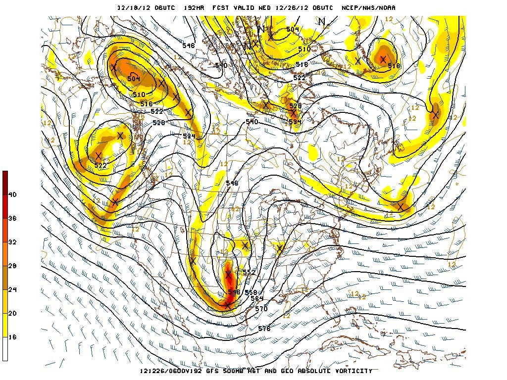
We've been watching as the models have struggled to make sense of the chaotic changing winter atmosphere. There have been signs for some time that have pointed toward a pattern change toward the end of the month, and more and more people are getting on board with that thought. I've included four different quotes below, all suggesting that we will see some major changes in our weather right around or shortly after Christmas, and the signs are getting a little more focused on a major system developing and potentially bringing cold and winter precipitation to parts of the southeast. We're still a long way off and the whole system could change or even disappear. But it is beginning to become apparent that the models are latching on to something big for next week. The bold are my highlights.
This from a meteorologist in Texas:
Find out what's happening in Daculafor free with the latest updates from Patch.
"The overnight guidance and ensembles continue to advertise a major winter storm event potential cross the Southern Rockies/Southern Plains during the busy Christmas Holiday travel period. The Euro is a bit faster by 12-24 hours ejecting a powerful trough across Texas/Oklahoma, while the GFS suggests a meandering closed core 5H low tracking a southern track across Central/SE Texas into Louisiana/Arkansas. Normally we see the GFS suggesting a more progressive pattern while the European guidance is slower. The Operation and ensembles paint a very interesting Winter Storm across a region that does not normally see this type of potential setup. Very cold air with wintry weather may extend as far S as Houston/Lake Charles with possible blizzard condition from N Cental TX/Oklahoma (Dallas/OKC) on E. Very cold sub freezing temps may reach as far S as the S Central Texas and on E along the Gulf Coast depending on the final storm track. The blocking regime does suggest abit more southerly track across the CONUS during the upcoming busy travel period. This feature may also offer a severe episode as well as it ejects from the Southern Rockies on Christmas Day."
And this from the Birmingham National Weather Service office this morning (Tuesday 18th):
Find out what's happening in Daculafor free with the latest updates from Patch.
"AS IF ALL OF THIS ISN'T ENOUGH...CHRISTMAS WEEK IS SHAPING UP TO BE VERY INTERESTING AS WELL. ANOTHER EXTREMELY DYNAMIC SYSTEM IS IN OUR LONG RANGE GUIDANCE. WHILE I'M NOT EXTREMELY IMPRESSED WITH THE LOOKS OF SEVERE WEATHER ATTM...A GOOD AMOUNT OF RAIN COULD BE IN THE CARDS FOR CENTRAL ALABAMA CHRISTMAS DAY. IT'S THE BACKSIDE OF THIS SYSTEM THAT WILL LIKELY GET MOST PEOPLE IN A TIZZY AS THICKNESS VALUES COUPLED WITH SOME LEFT OVER MOISTURE COULD SPELL SOME OF THE UNMENTIONABLE BY THE END OF NEXT WEEK. KEEP IN MIND...THIS IS WELL OFF TOWARDS THE END OF OUR MODELS...SO THIS COULD VERY WELL NOT BE THE CASE COME THE MOMENT OF TRUTH...BUT WITH BOTH OF OUR LONG RANGE MODELS SHOWING THE IDEA OF THIS SYSTEM FOR THE LAST FEW DAYS...I HAVE GONE ABOVE GUIDANCE FOR POPS IN DAY 8."
In addition, my buddy Robert Gamble at WXSouth.com had this to say:
"For now I say batten down the hatches and prepare for a rough stormy ride starting right after Christmas and likely beyond. It looks to turn generally colder for awhile following this storm. I’ll also say I won’t be surprised to see the models begin shifting soutward more if the 50/50 vortex shows some staying power. The models never account enough for that, but the big question we don’t know is how strong a vortex that will be. This looks like a major precip event as well for the entire southeast except maybe central and southern Florida. Wrap around snowfall could likely occur in the Tenn Valley as far south as Alabama on the storms backside, with front end snow to ice on the eastern side of the Apps."
And finally, the Hydrometeorological Predication Center this morning:
"THE BULK OF GUIDANCE FROM MOST MODELS AND ENSEMBLES OFFER A REASONABLY SIMILAR LARGER SCALE PATTERN EVOLUTION FOR THE NEXT WEEK. THIS FLOW IS HIGHLIGHTED ALOFT THIS WEEKEND BY AN AMPLIFIED TROUGH JUST OFF/ALONG THE WEST COAST...AN AMPLIFIED RIDGE OVER THE W-CENTRAL US...AND ANOTHER AMPLIFIED TROUGH/CLOSED LOW CENTEREDOVER THE NORTHEAST. THE LEAD SYSTEM AND ASSOCIATED DEEP SURFACE LOW/SYSTEM AND ASSOCIATED SENSIBLE WINTER WEATHER FOCUS SHOULD PROVE SLOW TO EXIT INTO THE CANADIAN MARITIMES WORKING INTO BLOCKED FLOW. THIS WILL LEAVE PLENTY OF ROOM FOR COOLING BACK ACROSS THE ERN AND CENTRAL US DOWN THROUGH THE SRN TIER STATES WELL IN ITS WAKE...INCLUDING PROTRACTED LAKE EFFECT SNOW POTENTIAL. UPSTREAM...ERN PACIFIC TROUGH ENERGIES AND ASSOCIATED UNSETTLED WEATHER/COOLING/PCPN ARE EXPECTED TO WORK INLAND ACROSS THE WRN US BY SUN/MON BEFORE EMERGING INTO THE CENTRAL US NEXT TUE WHERE SRN PLAINS CYCLOGENESIS/GULF INFLOW/DEVELOPING PCPN COULD OCCUR TUCKED UNDERNEATH A MID-HIGHER LATITUDE DOME OF COLDER HIGH PRESSURE."
Time to think about waxing the runners... :-)
Please remember, whenever you need weather information, please visit us at the new and improved DaculaWeather.com. You can also get the latest weather information by following us on Twitter and Facebook DaculaWeather.com... Your Window to the Weather