
You've gotta love these great temperatures and sunny days! If it wasn't for the pollen, it would be almost perfect!
There are however, some changes to the weather that may make it feel like late winter instead of spring! While it won't be freezing, lows may get down into the upper 30s instead of the mid 50s to 60s we're experiencing right now.
We're watching our next system as it takes shape in the middle of the country today. A portion of that area (centered around Oklahoma) is under a Moderate Risk for severe weather today. When it appears that there may be a larger scale severe weather event, the NWS will begin to issue "Public Severe Weather Outlooks" which they did this morning.
Find out what's happening in Daculafor free with the latest updates from Patch.
PUBLIC SEVERE WEATHER OUTLOOK
NWS STORM PREDICTION CENTER NORMAN OK
0302 AM CDT WED APR 17 2013
...SEVERE THUNDERSTORMS EXPECTED OVER PARTS OF THE SOUTHERN/CENTRAL PLAINS LATER TODAY AND TONIGHT...
THE NWS STORM PREDICTION CENTER IN NORMAN OK IS FORECASTING THE DEVELOPMENT OF TORNADOES... LARGE HAIL AND DAMAGING WINDS OVER PARTS OF THE SOUTHERN/CENTRAL PLAINS LATER TODAY AND TONIGHT.
THE AREAS MOST LIKELY TO EXPERIENCE THIS ACTIVITY INCLUDE
SOUTHEASTERN KANSAS
FAR WESTERN MISSOURI
MUCH OF OKLAHOMA
FAR NORTHERN TEXAS
Find out what's happening in Daculafor free with the latest updates from Patch.
ELSEWHERE... SEVERE STORMS ARE ALSO POSSIBLE FROM CENTRAL TEXAS INTO ILLINOIS.
WARM MOIST AND UNSTABLE AIR AT THE SURFACE WILL ADVANCE NORTHWARD INTO OKLAHOMA... MISSOURI... AND KANSAS LATER THIS AFTERNOON AS SOUTHERLY WINDS STRENGTHEN IN ADVANCE OF AN UPPER DISTURBANCE OVERTHE WESTERN UNITED STATES. SCATTERED TO NUMEROUS THUNDERSTORMS WILL FORM THIS AFTERNOON AND NIGHT ALONG THE LEADING EDGE OF THIS UNSTABLE AIRMASS FROM CENTRAL OKLAHOMA INTO EASTERN KANSAS AND WESTERN MISSOURI. THESE STORMS WILL BE CAPABLE OF PRODUCING VERY LARGE HAIL... DAMAGING WINDS... AND A COUPLE OF TORNADOES. FARTHER SOUTH OVER SOUTHERN PORTIONS OF OKLAHOMA AND NORTHERN TEXAS... ISOLATED THUNDERSTORM DEVELOPMENT IS EXPECTED TO OCCUR DURING THE LATE AFTERNOON AND EVENING. THE COMBINATION OF GREATER INSTABILITY AND STRONG VEERING WINDS ALOFT WILL RESULT IN A THREAT FOR VERY LARGE HAIL AND A FEW TORNADOES... SOME WHICH MAY BE STRONG. DURING THE OVERNIGHT... STORMS ACROSS THE ENTIRE REGION WILL MERGEINTO A SQUALL LINE WITH A CONTINUED THREAT FOR DAMAGING WINDS AND ISOLATED TORNADOES.
In addtion to the PWO, they have also decided to place GOES East in Rapid-Scan operations beginning at 9:14 a.m. this morning.
SENIOR DUTY METEOROLOGIST NWS ADMINISTRATIVE MESSAGE
NWS NCEP CENTRAL OPERATIONS COLLEGE PARK MD
1032Z WED APR 17 2013
RSO STATUS...
GOES-E RSO WILL BE IN PLACE FROM 1314Z 4/17 to 0114Z 4/18 IN
SUPPORT OF SPC SEVERE WX OPS.
SHRUELL/SDM/NCO/NCEP
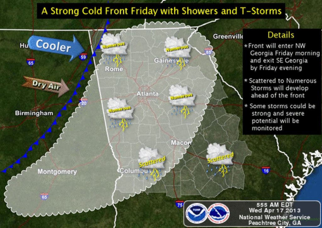
While what goes on today doesn't directly effect us, it is our next potential severe weather maker and bears watching as it approaches and enters our area on Friday. The Atlanta NWS had this to say about it in their AFD this morning:
MODELS STILL IN GOOD AGREEMENT WITH EXCELLENT RUN TO RUN CONSISTENCY WITH THIS STORM SYSTEM WHICH LOOKS TO EJECT OUT OF THE INTO THE LOCAL AREA LATE THU NIGHT INTO FRIDAY MORNING. TIMING FOR THE LOCAL AREA INDICATES BAND OF SHOWERS AND SCATTERED THUNDERSTORMS REACHING NW GEORGIA JUST PRIOR TO 12Z FRIDAY. INSTABILITY STILL LOOKS VERY MARGINAL FOR THIS EVENT WITH LITTLE IF ANY SURFACE BASED CAPE TO WORK WITH FOR NORTHERN SECTIONS. FRIDAY AFTERNOON VALUES ARE MARGINALLY BETTER WITH 300J/KG TO 600J/KG OVER CENTRAL GEORGIA. GIVEN MORE INSTABILITY TO THE SOUTH WITH THIS SYSTEM... WILL CONTINUE INCREASED THUNDER CHANCES ROUGHLY FROM THE ATLANTA METRO SOUTHWARD. 850MB JET IS VERY IMPRESSIVE WITH THIS SYSTEM WITH NEARLY 80 KTS INDICATED FOR THE OHIO VALLEY. OUR AREA ONLY GETS THE SOUTHERN END OF THIS BUT STILL GOOD ENOUGH FOR 60 KTS FOR NW CORNER. INSTABILITY LOOKS TO BE AHEAD OF MAIN WIND CORE SO TIMING MAY NOT LINE UP FOR THIS ONE. REGARDLESS...925MB WINDS ARE 50KTS OVER THE LOCAL AREA WHICH SHOULD RESULT IN NEAR SEVERE WINDS EVEN WITH THE ABSENCE OF ROBUST CONVECTION. WILL CONTINUE TO RAMP UP WORDING IN HWO.
So they currently don't seem too impressed by what they see for us, which obviously is a good thing. But as long as we keep the rain coming at least once a week, we should generally be in good shape as we begin the summer months.
Please remember, whenever you need weather information, please visit us at the new and improved DaculaWeather.com. You can also get the latest weather information by following us on Twitter and Facebook DaculaWeather.com... Your Window to the Weather