Health & Fitness
Potential Severe Weather Event Thursday
The start of Spring brings the chance for severe weather
It's that time of year when we have the clash of the titans... cold arctic air pushing south from Canada starts butting heads with the warm moist air that's trying to creep northward from the Gulf. The result is not always pretty, as this combination of air masses almost always brings severe weather to the south.
The Atlanta NWS office (I call them FFC which is the abbreviation for their office) had this to say in their morning area forecast discussion (AFD):
"...LONG TERM /TUESDAY NIGHT THROUGH SUNDAY/... POTENTIAL FOR A HEAVY RAIN/SEVERE WEATHER EVENT SETTING UP IN THE THURSDAY TO THURSDAY NIGHT TIMEFRAME. MODELS SIMILAR WITH SPREADING DEEPER MOISTURE INTO THE AREA LATE WEDNESDAY BUT THE MAIN PRECIP PERIOD LOOKS TO BE WEDNESDAY NIGHT THRU THURSDAY NIGHT. AN OVERRUNNING PATTERN WILL SET LATE WEDNESDAY/WEDNESDAY NIGHT WITH MODELS DEVELOPING A WARM FRONT ALONG THE GULF COAST. SURFACE LOW PRESSURE DEVELOPS OVER THE WESTERN GULF AND MOVES TO THE WESTERN FL PANHANDLE LATE THURSDAY AND THEN ACROSS CENTRAL TO S GA THURSDAY NIGHT/FRIDAY. THE GFS IS FASTER WITH THIS PROGRESSION THAN THE EUROPEAN. THIS TRACK COULD MOVE THE WARM FRONT INTO THE SE CWA AND GIVE POTENTIAL FOR SEVERE THUNDERSTORMS MAINLY THURSDAY NIGHT. IT WILL ALSO GIVE POTENTIAL FOR HEAVY RAIN ACROSS A LARGE PORTION OF EAST GEORGIA AND MODELS IN GENERAL ARE GUNG-HO WITH PRECIP AMOUNTS WITH A LARGE AREA OF 1-2 INCHES FORECAST."
Find out what's happening in Daculafor free with the latest updates from Patch.
Their Hazardous Weather Outlook (HWO) says this:
".DAYS TWO THROUGH SEVEN...TUESDAY THROUGH SUNDAY...
A MODERATE TO POSSIBLY HEAVY RAIN EVENT IS EXPECTED TO AFFECT THE
AREA IN THE THURSDAY TO THURSDAY NIGHT TIME FRAME. 1 TO 2 INCHES OF
RAIN CAN BE EXPECTED OVER A LARGE AREA WITH THE GREATEST AMOUNTS
OVER EAST GEORGIA. THERE IS STILL PLENTY OF UNCERTAINTY BUT A WARM
FRONT COULD MOVE INTO CENTRAL GEORGIA THURSDAY NIGHT GIVING THE
POTENTIAL FOR SEVERE THUNDERSTORMS."
Find out what's happening in Daculafor free with the latest updates from Patch.
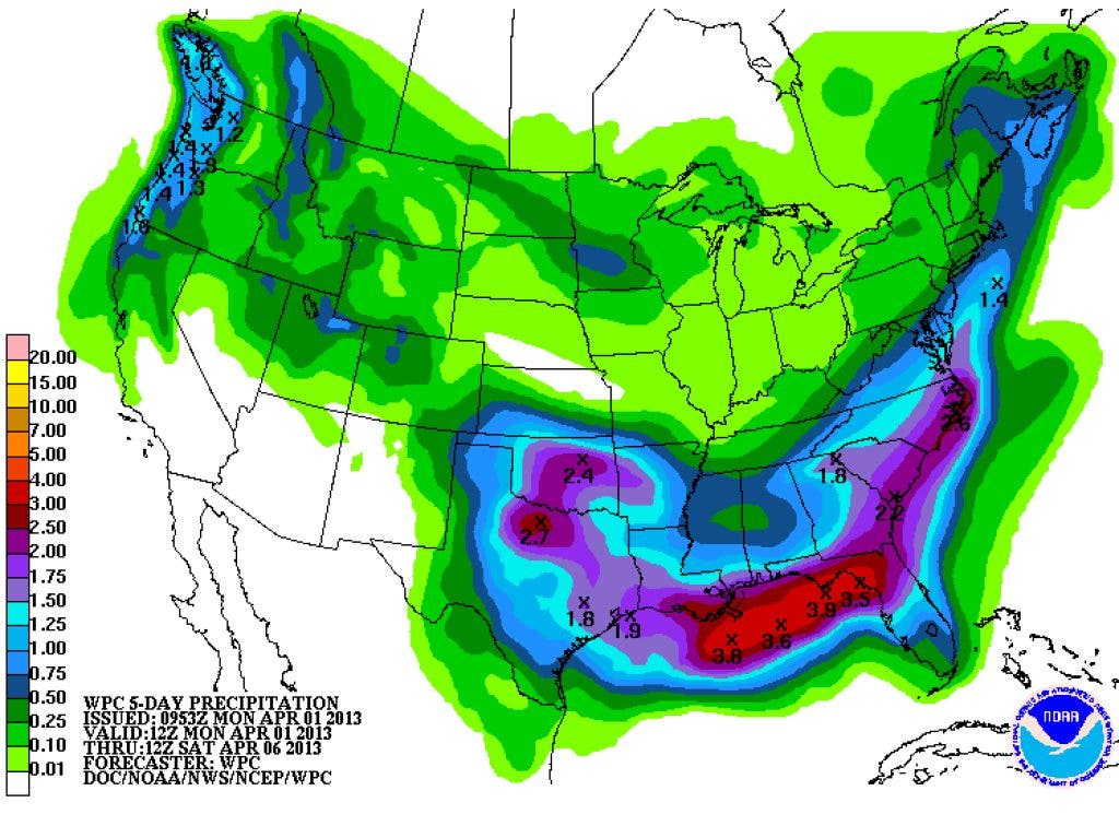
The WPC has been advertising around 1-2" of precipitation for our area over the next five days as well. We'll be dry today and tomorrow, but clouds and moisture will begin to return on Wednesday. Our temperatures should be pretty close to normal for the next few days, but the really warm spring temps aren't here quite yet. There could be another cool down later this weekend into next week, but that's a little too far down the road for us to worry about right now. The pollen count has started to creep back up into the high range and I have a feeling it's about ready to bust wide open.
I have a couple of new loops from the WPC, one is a 7 day QPF (rain amounts) loop and the other is a probability loop for rainfall.
Also... I've really started to use the NWS Enhanced Data Display (or EDD for short). The meteorologist I've been in touch with is the lead developer for both the full size and the mobile page, and he is doing an outstanding job. The product keeps getting better and better and is crammed full of features. They have recently created a Facebook page for EDD, and on the page have videos that explain all of the various features and layers that can now be accessed. The link to the page is here but I've also added it to my main page at the top right under "National Summary."
I had to include this link. This is an image from Expedition 35 crew members aboard the Earth-orbiting International Space Station, of New York City at night. Beautiful view, enjoy! Oh... I also had a chance to view the IMAX Hubble 3D on my TV the other night. Just incredible. I've got to say, 3D at home is MUCH better than 3D at the theater, it's much brighter, sharper, and just more enjoyable at home. The images and videos are stunning. Highly recommended if you have a 3D TV.
Please remember, whenever you need weather information, please visit us at the new and improved DaculaWeather.com. You can also get the latest weather information by following us on Twitter and Facebook DaculaWeather.com... Your Window to the Weather