Health & Fitness
Springtime Weather May Turn Severe Next Week
The danger for severe weather may be on the increase next week

Spring is finally here, even though we had a very chilly day the other day. And again, it's those clashes of cold and warm air that bring those spring showers... and severe weather.
This morning, the Storm Prediction Center (SPC) had this to say in their 4-8 day outlook:
http://www.daculaweather.com/4_spc_day4-8_outlook.php
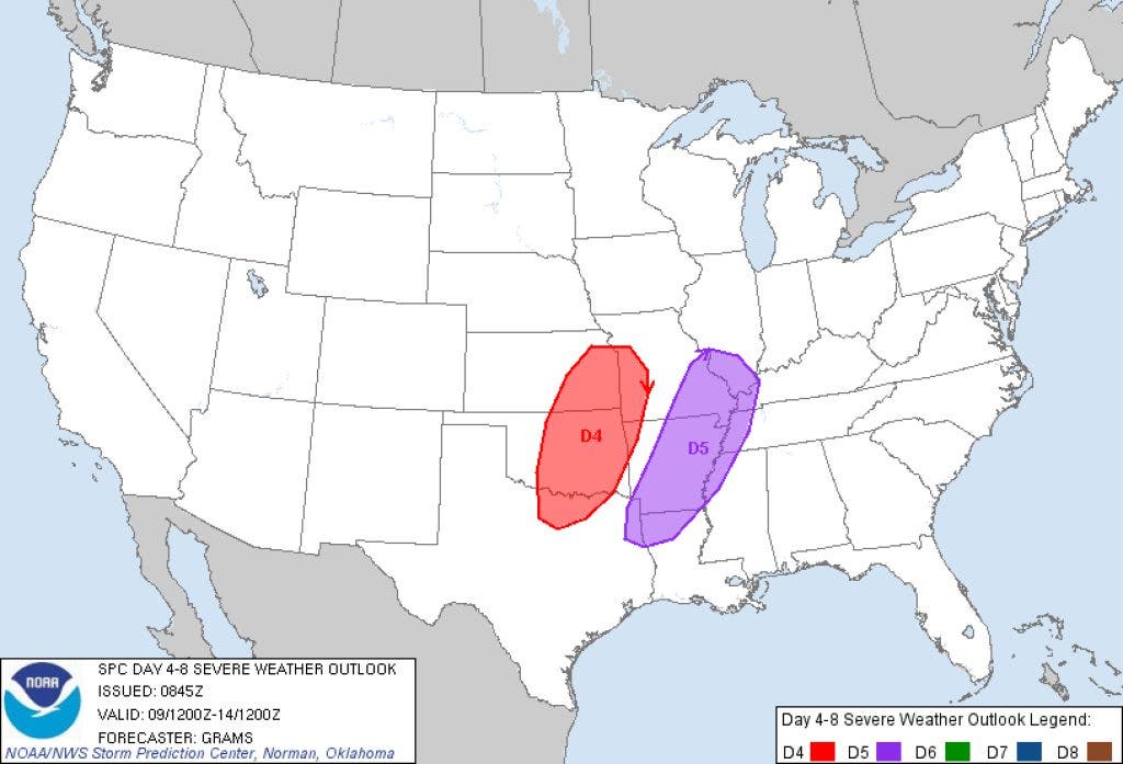
DAY 4-8 CONVECTIVE OUTLOOK
NWS STORM PREDICTION CENTER
NORMAN OK 0345 AM CDT SAT APR 06 2013
VALID 091200Z - 141200Z
Find out what's happening in Daculafor free with the latest updates from Patch.
...DISCUSSION...
MULTI-DAY SEVERE WEATHER EPISODE IS EXPECTED ACROSS PARTS OF THE S-CNTRL AND PERHAPS EVENTUALLY THE SOUTHEASTERN CONUS IN ASSOCIATION WITH AN UPPER-LEVEL TROUGH PROGRESSING EWD FROM THE WRN CONUS. PRECEDING DAYS OF SOUTHERLY RETURN FLOW OF A MODIFIED GULF AIR MASS BENEATH A STOUT EML SHOULD YIELD AT LEAST MODERATELY UNSTABLE CONDITIONS AHEAD OF THE PLAINS DRYLINE BEING OVERTAKEN BY A COLD FRONT THAT WILL PROGRESS EASTWARD DURING THE PERIOD.
Find out what's happening in Daculafor free with the latest updates from Patch.
WITH STRENGTHENING OF MID-LEVEL SOUTHWESTERLYS AS THE SPEED MAX EJECTS FROM THE BASE OF THE WESTERN CONUS TROUGH...SETUP SHOULD BE FAVORABLE FOR SUPERCELLS AND AN EVENTUAL SQUALL LINE WITH ALL MODES OF SEVERE /SOME SIGNIFICANT/ PROBABLE DURING D4-5. STILL...CONFIDENCE IS ONLY AVERAGE FOR HIGHLIGHTING CORRIDORS OF ENHANCED COVERAGE PROBABILITIES /AOA 30 PERCENT/ AS MODELS REMAIN MODERATELY DIVERGENT WITH TIMING OF THE KEY SYNOPTIC FEATURES DURING THIS TIME FRAME.
DISCREPANCIES WITH EVOLUTION OF THE UPPER-LEVEL TROUGH AND ATTENDANT COLD FRONT BECOME EVEN GREATER BY D6-7...WHERE SEVERE WEATHER AREAS COULD EVENTUALLY BE WARRANTED IN PARTS OF THE SOUTHEAST.
We're still almost a week away and the details aren't clear at this point, but it's something that bears watching as we get closer to that time. This is the prime time of the year for severe weather, so each system that approaches our area has the potential to generate severe thunderstorms, hail, and even tornadoes.
Since it's the time of year for severe weather, here is a video from the Storm Prediction Center that will help keep you aware and safe when severe weather approaches, as well as a Tornado FAQ:
- What's a Watch? (YouTube video)
- Tornado FAQ's
We'll have more on this throughout the week in my safe and secure location in Sarasota Florida. :-) In case you need to know, the forecast there is upper 70s to low 80s and sunny. http://www.daculaweather.com/4_forecast_fl.php?z=23 And if you're headed to Florida on Spring Break, I have the official forecast for just about any destination there. Just click on the link above and in the drop-down box, choose your location.
I'll send pictures... :-)
Please remember, whenever you need weather information, please visit us at the new and improved DaculaWeather.com. You can also get the latest weather information by following us on Twitter and Facebook DaculaWeather.com... Your Window to the Weather