Health & Fitness
Possibility of Storms This Weekend, NWS Says Timing 'Is a Crap Shoot at This Point'
Heavy rain with potential flash flooding may be the norm for this weekend.


At first I wasn't going to write about this event, but the after what I've seen and now what I've read, I believe it's worth a post.
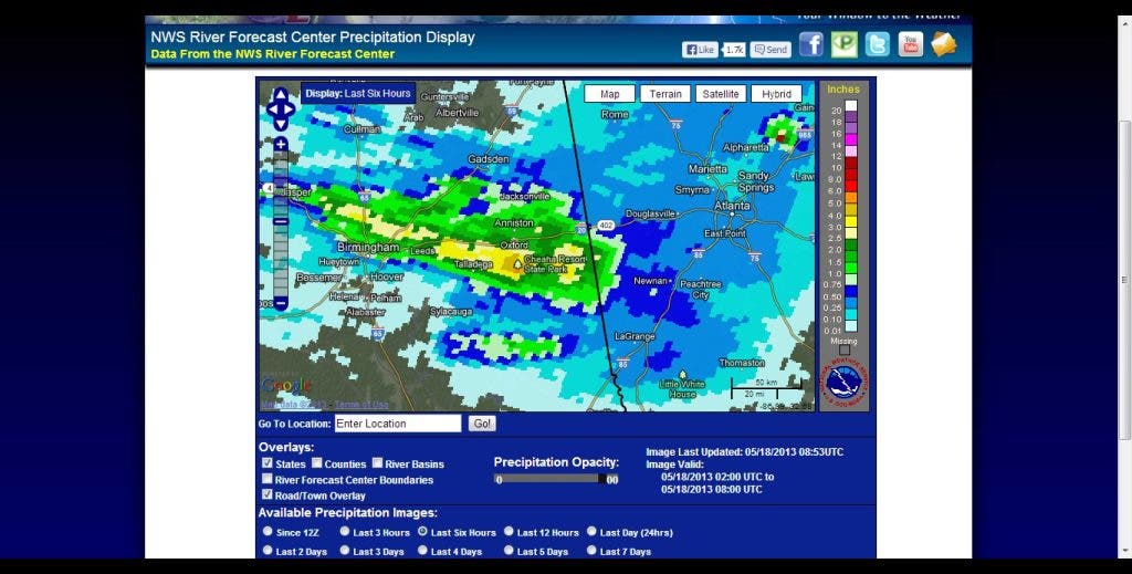
Overnight, Alabama was hit hard by rain, with the last 6 hour radar estimates showing 2 - 6" of rain, with areas around Cheaha Resort State Park showing 6-8" over the last 24 hours. A stubborn MCS (Mesoscale Convective System) that brought us some rain last night was responsible for the activity, and is still going at it this morning. The outflow boundaries from that as well as Mesoscale Convective Vorticies will help initiate additional storms today.
Find out what's happening in Daculafor free with the latest updates from Patch.
.SHORT TERM /TODAY THROUGH SUNDAY/...
COMPLEX AND DIFFICULT FORECAST THE NEXT 24 TO 36 HOURS. SLOW MOVING AND WEAK UPPER LEVEL LOW NOTED IN WATER VAPOR OVER CENTRAL TN RESPONSIBLE FOR SHOWERS AND A FEW STORMS MOVING INTO WESTERN GA NOW THROUGH SAT AM. MODELS CONTINUE TO KEEP THE REGION IN A GENERAL NORTHWEST FLOW PATTERN THROUGH SUNDAY WITH WEAK DISTURBANCES MOVING SOUTHEAST ON THE SOUTHWEST SIDE OF THE WEAK UPPER LOW.
ALL OF THE MODELS AGREE ON CHANCE TO LIKELY POPS FOR A PORTION OF THE AREA BUT DISAGREE ON EXACT LOCATION AND TIMING...MOST LIKELY DUE TO DIFFICULTIES RESOLVING THESE FEATURES. FOR TODAY...BIG QUESTION WITH THIS ONGOING ACTIVITY IS HOW MUCH CLOUD DEBRIS WILL REMAIN AND HINDER OR DELAY ANY DAYTIME HEATING ACROSS GA AND THE ONSET OF THUNDERSTORM DEVELOPMENT.
-------------
But today may not be the worst day. Tomorrow is shaping up to possibly be wetter with potentially a chance for severe storms.
Find out what's happening in Daculafor free with the latest updates from Patch.
--------------
WILL HAVE TO WATCH AREA SAT NIGHT INTO SUNDAY AS SEVERAL MODELS ARE HINTING AT SOME TYPE OF MCS DEVELOPMENT IN NORTHERN AL AND TN. GIVEN THE NORTHWEST FLOW AND THESE DISTURBANCES...CANT RULE IT OUT.
GFS INSTABILITY FORECAST FOR SUNDAY IS IMPRESSIVE WITH 500 TO 700 MB LAPSE RATES OVER 8 DEG C/KM FOR NORTHWEST GA. ALONG WITH CAPE VALUES 2000 TO AS MUCH AS 4000 J/KG ... THERE WILL BE SOME SEVERE POTENTIAL...HOWEVER SHEAR VALUES ARE LESS THAN MARGINAL SO CONFIDENCE ON A MORE WIDESPREAD SEVERE EVENT IS LESS. MAIN IMPACTS WILL BE DAMAGING WINDS AND HAIL.
TIMING OF STORMS ON SUNDAY IS A CRAP SHOOT AT THIS POINT AND MODEL TIMING IS ALL OVER THE PLACE GIVEN THE POTENTIAL MCS DEVELOPMENT EARLY ON SUN. NEEDLESS TO SAY...WILL NEED TO WATCH THE FORECAST CLOSELY THROUGH THE WEEKEND AS IT COULD CHANGE SIGNIFICANTLY FOR BETTER OR WORSE.
----------------
Better or for worse... hmmm, I've heard those words before... where DID I hear that? ;-)
So please be aware of the weather conditions both today and tomorrow. With PW vaules around 1.5", heavy rain will be the primary threat today with flash flooding possible. One hour Flash Flood guidance shows that we would need around 2.5-3" of rain over our area to begin to create flooding conditions.
http://www.daculaweather.com/4_flash_flood_guidance.php
But due to the potential rainfall in these MCS's, the threat will continue for the possibility of flooding. No watches are in place right now due to the seemingly random and unpredictable nature of the MCS's. The NWS mentioned this in the morning AFD:
HIGH PW VALUES AND THE SLOW MOVING NATURE OF THESE DISTURBANCES HAVE THE POTENTIAL TO PRODUCE SOME ISOLATED FLASH FLOODING...PARTICULARLY ACROSS NORTH GA BOTH SAT AND SUN. WILL NEED TO ALSO MONITOR THIS AS WELL AS THE SEVERE THREAT.
-----------
On the new NWS EDD display, there is an option at the very bottom that allows you to display Storm Reports, and several places in Alabama are reporting roads completely covered by water. Once the sun comes up, I'm sure more reports of flooding will be coming in. You may also find storm reports from the Storm Prediction Center here.
Please remember, whenever you need weather information, please visit us at the new and improved DaculaWeather.com. You can also get the latest weather information by following us on Twitter and Facebook DaculaWeather.com... Your Window to the Weather