Health & Fitness
Cold to Severe... you're in Georgia
As people say, if you don't like the weather here, wait a day.


I love transition months. There is always weather to talk about as the patterns are changing and the atmosphere is very active and sometimes chaotic.
Did you enjoy the little cold outbreak we just had? It was a nice early winter preview and despite what some forecasters are saying about this winter, I believe it's going to be a good one. My low on Wednesday morning was 20.6 F and so far this morning, I'm sitting at 21.9 F for a low, and I've been below freezing for more than 8 hours now. You can see interactive weather graphs with data from my weather station here.
Temp Departure from Normal
Yesterday Min/Max
24 hour temp change
Over the next 6-10 days, the temperatures should stay below normal in the eastern part of the country as anomalous upper air troughing takes hold, (Map for temps | Map for precip) while our precipitation remains around normal.
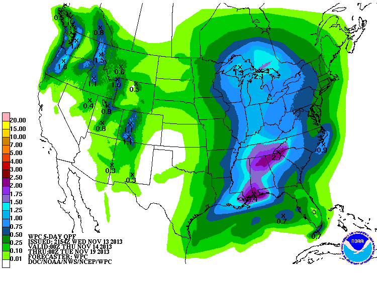
Beginning today, our winds will begin to shift from the NE to the E to the SE as the large high that brought us the cold weather begins to shift off to the east, and brings a return flow of moisture to our area. Clouds will be on the increase tomorrow with our chances for rain beginning tomorrow afternoon and continuing through Monday. The latest QPF (Quantitative Precipitation Forecast... or rainfall amounts) map shows parts of north Georgia getting more than 2" of rainfall over the next 5 days. I also have a QPF Forecast Discussion page where the WPC talks about... yes, you guessed it, precipitation! We've been a little dry lately so this will be a much welcomed rain event.
The latest area forecast discussion (known as AFD's... and I have these for every forecast office in the country on DaculaWeather.com) talks a little about the potential for severe weather as the front approaches the metro area on Sunday/Monday
WHILE FORECAST MUCAPE VALUES ARE QUITE LIMITED AHEAD AND ALONG THE FRONT AT 200-400 J/KG...THIS LOOKS TO BE THE MAIN LIMITING FACTOR FOR SEVERE POTENTIAL. DECENT ENVIRONMENTAL SHEAR SHOULD BE IN PLACE WITH 0-6 KM BULK NEAR 40-50 KTS...0-1 KM BULK NEAR 20-30 KTS...AND DECENT HELICITY. WILL DEFINITELY HAVE TO KEEP A CLOSE MONITOR ON INSTABILITY/SHEAR COMBO AS ORGANIZED STRONG TO SEVERE DEVELOPMENT IS A POSSIBILITY.
Basically you don't have a lot of rising air (no big change in temp with height) but there is a lot of shear (change in wind direction with height) and helicity (rotation of the wind). we'll keep an eye on this and keep you updated as the time gets closer.
Like what you read here and want to be notified of new posts and updates? You can subscribe to this weather blog by clicking here and then clicking on "Get email updates"
Please remember, whenever you need weather information, please visit us at DaculaWeather.com. You can also get the latest weather information by following us on Twitter, Facebook, and here on the Patch! DaculaWeather.com... Your Window to the Weather