


Still not completely out of the woods yet with the approaching cold front on Sunday.
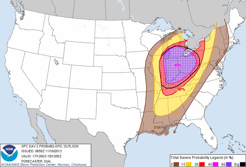
The Storm Prediction Center (SPC) has included the northwest corner of Georgia in the "Slight Risk" area for severe weather tomorrow, but it looks as though most of the bad weather will stay north of our area. The latest AFD from the Atlanta NWS office included this:
HEAVIER PRECIP MOVES IN LATE TONIGHT AND SUNDAY OVER NORTH GA AND AS LOW LEVEL MOISTURE CONTINUES TO RISE DURING THE DAY... COULD SEE SOME DEEP CONVECTION DEVELOP AS EARLY AS THE AFTERNOON.
BASED ON 00Z GFS... WHICH TENDS TO VERIFY BETTER THAN THE NAM AND HIRES MODELS FOR SVR CONVECTIVE PARAMETERS... MLCAPE COULD PEAK AROUND 250-500 J/KG OVER NW GA AT 00Z. VERTICAL WIND SHEAR ARE A LITTLE STRONGER THAN SHOWN IN YESTERDAYS MODEL RUNS. 0-1KM BULK SHEAR MAGNITUDES NOW SHOWING VALUES 35-40KTS OVER NORTH GA. SIG TOR PARAMETER VALUES NOW APPROACHING 1.0 OVER NW GA WITH VALUES NEAR 2-3 OVER FROM NRN MS TO CENTRAL TN. AGREE WITH LATEST DAY 2 OUTLOOK FROM SPC THAT INCLUDES NW GA THOUGH LARGER THREAT MAY REMAIN TO NW OF CWA.
PRIMARY THREAT WITH ANY STORMS WILL BE DAMAGING WIND. ISOLD TORNADO ALSO POSSIBLE OVER NW GA IF A LITTLE MORE INSTABILITY AND/OR SHEAR DEVELOPS THAN FCST. MODEL PROGS BOTH WEAKEN SHEAR AND INSTABILITY AFTER MIDNIGHT...SO THREAT WILL DIMINISH QUICKLY.
Once the front passes, cooler temperatures return.
We've been watching the long range models with interest, and it appears the NAO and AO are going to be headed down and possibly be turning negative, a good sign for cold in our part of the country. The models have been hinting at blocking in the long term, and as Robert Gamble at WXSouth.com alluded to in his blog, it seems to be a persistent recurring pattern from this year and is something to watch.
Steven Nelson, the Atlanta NWS Chief Science and Operations Officer, talked about the next system on the horizon.
"NEXT CHANCE OF RAIN NOT LIKELY UNTIL THE FOLLOWING WEEKEND AS A POSITIVELY TILTED WAVE IN SPLIT FLOW MOVES EAST OVER SOUTHERN CONUS LATITUDES. GFS AND ECMWF WANT TO BRING A STRONG ARCTIC HIGH SOUTH INTO THE PLAINS WITH THIS SYSTEM... BUT MAY MODERATE QUITE A BIT BEFORE IT GETS HERE. 00Z ECMWF IN PARTICULAR SHOWS SFC HIGH PRESSURES ABOVE 1050MB IN THE CO HIGH PLAINS FRIDAY. DISLIKING THESE ARCTIC AIR MASSES COMING DOWN SO EARLY THIS YEAR. SHIVER."
The last cold shot of air had what started as roughly a 1040mb high, 1050mb is VERY high. There is a lot of cold air on our side of the northern hemisphere right now, with the right blocking in place, we could see some colder than normal weather in the not so distant future.
I have a temperature chart from data collected here at DaculaWeather.com, it appears that it's working for the most part this year. I took it down last year due to data that would go missing for no particular reason... but for the most part, appears to be working. I think it's interesting to see the temperature data visually.
And once again, every Thursday, the latest NWS weekly video comes out and you can find it and others here as well on my main page at DaculaWeather.com
----------------------------------------------------------
Like what you read here and want to be notified of new posts and updates? You can subscribe to this weather blog by clicking here and then clicking on "Get email updates"
Please remember, whenever you need weather information, please visit us at DaculaWeather.com. You can also get the latest weather information by following us on Twitter, Facebook, and here on the Patch! DaculaWeather.com... Your Window to the Weather