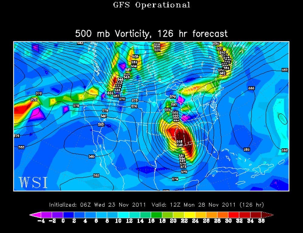


I thought this next system deserved it's own post as it has been described as potentially a 30-50 year event. As I discussed in my previous post on the 21st, the models began showing a very large upper level low pressure system forming a cut-off low over the southeast. Since then, the models are even more insistent in this scenario with the GFS holding steady and leading the way in depicting the track and intensity. The latest GFS that came out around 6 am this morning is showing a very strong low with the potential for some light snow/snow flurries even as far south as Atlanta on Tuesday morning. I know it sounds far fetched, especially for this time of the year, but depending on the track and strength of the upper low, the possibility is there. Obviously the ground is very warm so the chance of accumulating precipitation is very low.
First, an upper level low at this time of year often carries a very cold upper core of air. You'll notice in the discussions by the meteorologist, they'll talk about 4 or 5 contour low. What they're referring to is the number of closed isobars surrounding the core. The greater the number, the stronger and deeper the low. What is being depicted by the GFS is a very strong and deep low for this time of the year, and lows such as this one have the ability to make their own weather so to speak. In this situation, it will be possible for the low to pull the very cold upper air down closer to the surface and we get the dreaded 4 letter word. Watch this loop (quickly, it will change during the next update) and notice how the low from the California coast travels east and at least partially phases with the parcel of energy dropping out of the Rockies to form the low. Then notice how the low explodes and takes on a negative tilt. There are two burst of energy and it's the second wave that might bring the snow.
I wanted to once again include the comments and perspective of Robert Gamble. His expertise in southeast weather and particularly winter events, provides the insight that only meteorologist can bring. You can follow Robert's blog at http://www.shelbyweather.blogspot.com/
"Earlier the models, esp. GFS were insisting that all the energy from the northern stream drops due south along the front range of the Rockies to help form the extreme low lat. cutoff, but that's going to be hard to do. It would require enormous ridging in the east Pac or British Columbia and I don't quite see that yet , and it would be incredibly rare to get a cutoff so deep and far south (but if any year could do it, this is the one). We may end up with something more like ECMWF and a watered down version of GFS, with partial phasing of northern stream. That scenario would be warmer under the cutoff. By the way, the GFS would still be hard to snow in the lower elevations east of the mtns , remember there's usually a warm bubble east of the mountains unless high pressure is pushing south on both sides of the Apps, so I don't see this as March 2009. Soundings right now would lead you astray east of the Apps since the models almost always make it too cold east of the Apps in this situation. But believe it or not major snow is possible on the nw side of the low whereever that ends up being, can't say yet, but if a deep cutoff happens this far south, then Tenn and surrounding areas from Apps, west are possible, including ATL and HSV. The ECMWF isn't that cold though, but gets very close, even without it fully phasing the northern stream. If the northern stream comes in like the sudden injection GFS has been having, some -4 at 850 would be good enough at night and early mornings for the flakes to fall, but so far no model has a lot of moisture or lift underneath the best cold air (except maybe GFS has a weak deformation type band or moisture convergence in nw side).
The biggest deal still could be the high winds, a possible well developed LLJ which models still don't show or bring to surface but if a Full-Lat trough occurs and reaches the Gulf Coast, I think they will start to show it. Severe line also, esp. once the system begins cutting off, which would develop a south to north line of severe, and including heavy rain threat to the Apps and western Carolinas and ATL AHN region of GA to the Apps. Strong southeast upslope would occur in the mtns esp NC and ne GA mtns with the GFS setup, producing 5" of rain easily, with much more in the sw mtns of NC if the system stalls like GFS, but can't say for sure. One thing about the rain rates, they will be high if the GFS is right on the sharpness of the trough. Maybe .50" to .75" per hour in an a band directly along the mid level front in the Gulf region, from east Tx to La and central /N. Mississipp, that could carry east as the line expands. That would be flash type flooding. Here's just a 6 hour window as it begins, but models probably under-do the rates on a super-sharp trough this far south.
So we're entering an even harder time to forecast than what we've just been through, and that's saying a lot. Does the pattern change to colder like GFS has? Maybe, but if its wrong on this cutoff too much, then maybe not much of a colder pattern. But all models seem to be showing a weak western ridge + PNA pattern so I think we probably will get into colder pattern. But there still no shortage of energy in the flow and cutoff's galore. That could make for a continuation of this extremely active pattern. Its been a strange pattern for a NINA. Already I'm about normal for the year's rainfall, not below. Some parts of the county are already above for the year, with a solid month to go, guaranteeing an above normal rainfall year. For a year that was in solid Nina mode, and a hot Summer, that's pretty surprising and I never would have dreamed that just a year ago...I've had about as much rain as some el Nino patterns could do."
We still have 4-5 days before the system arrives and much can happen as you can see here. That uncertainty is what makes winter storms so much fun to track and this one will certainly be no exception. And the fact that it's so early in the year makes it even more interesting. What do you think, are you ready for snow?
Please remember, whenever you need weather information, please visit us at DaculaWeather.com. You can also get the latest weather information by following us on Twitter and Facebook DaculaWeather.com... Your Window to the Weather