Weather
Atlanta Under Tropical Storm Warning, Prepare Now
While it's hundreds of miles from the coast, the Atlanta metro is under a tropical storm warning as Hurricane Irma heads north.

ATLANTA, GA — While it's hundreds of miles from the coast, the Atlanta metro is under a tropical storm warning as monster storm Hurricane Irma — some 400 miles across as it moved across Florida Sunday — heads north. The warning is in place to urge Georgians to prepare for high winds, downed trees and widespread power outages. From 8 a.m. Monday into Tuesday morning, much of Georgia, including the Atlanta area, will be lashed by 30 to 40 mph winds with gusts of 55 mph and heavy rain as Irma barrels through the Southeast, weather forecasters say.
And Irma's misery is likely to encompass much of the state with downed trees and power outages. Central Georgia is also under a tropical storm warning, while the southern tiers of counties closest to Florida are under a hurricane warning, according to the National Weather Service. Meteorologists at the NWS office in Peachtree City caution that the areas included in watches and warnings could change as the hurricane makes its way up Florida.
"Trees are going to come down with this, it's not even going to take this much wind. Power lines come down with those trees … it's gonna meant power outages and those outages could last a decent while. That's what we want everybody to be prepared for," the office said on its Twitter feed. (Get Patch's Daily Newsletter and Real Time News Alerts. Or, if you have an iPhone, download the free Patch app.)
Find out what's happening in Sandy Springsfor free with the latest updates from Patch.
Watch: Hurricane Irma Officially Arrives In Florida
SEE ALSO:
Find out what's happening in Sandy Springsfor free with the latest updates from Patch.
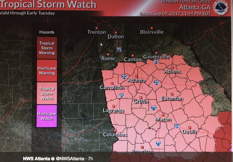
Tropical Storm Watch, Warning Areas
A Tropical Storm Watch is in effect for Banks, Catoosa, Dade, Dawson, Fannin, Gilmer, Hall, Lumpkin, Murray, Towns, Union, Walker, White, and Whitfield counties.
A Tropical Storm Warning is in effect for Baldwin, Barrow, Bartow, Bibb, Bleckley, Butts, Carroll, Chattahoochee, Chattooga, Cherokee, Clarke, Clayton, Cobb, Coweta, Crawford, Crisp, DeKalb, Dodge, Dooly, Douglas, Emanuel, Fayette, Floyd, Forsyth, Fulton Glascock, Gordon, Greene, Gwinnett, Hancock, Haralson, Harris, Heard, Henry, Houston, Jackson, Jasper, Jefferson, Johnson, Jones, Lamar, Laurens, Macon, Madison, Marion, Meriwether, Monroe, Montgomery, Morgan, Muscogee, Newton, Oconee, Oglethorpe, Paulding, Peach, Pickens, Pike, Polk, Pulaski, Putnam, Rockdale, Schley, Spalding, Stewart, Sumter, Talbot, Taliaferro, Taylor, Telfair, Toombs, Treutlen, Troup, Twiggs, Upson, Walton, Warren, Washington, Webster, Wheeler, Wilcox, Wilkes, and Wilkinson counties.
The National Hurricane Center track has Irma starting its track northward and strengthening slightly before making landfall along the west coast of Florida. The storm will then pick up speed as it continues north into portions of south central Georgia as a weakening category one hurricane.
Portions of Central Georgia can expect tropical storm force winds beginning late Sunday night with North Georgia seeing these winds by Monday morning. During the day Monday, winds should increase to 40 to 50 mph, with gusts as high as 70 mph.
Because of the wet spring and early summer, the strong winds will easily bring trees down across the area which will also lead to widespread power outages. Residents should be prepared in some cases to be without power for several days and stock up on supplies accordingly. Tropical storm force winds are expected to move out of the area late Monday night.
Potential Wind Affects
- Prepare for dangerous wind having possible significant impacts across portions of North and Central Georgia. Potential impacts in this area include:
- Some damage to roofing and siding materials, along with damage to porches, awnings, carports, and sheds. A few buildings experiencing window, door, and garage door failures. Mobile homes damaged, especially if unanchored. Unsecured lightweight objects become dangerous projectiles.
- Several large trees snapped or uprooted, but with greater numbers in places where trees are shallow rooted. Several fences and roadway signs blown over.
- Some roads impassable from large debris, and more within urban or heavily wooded places. A few bridges, causeways, and access routes impassable.
- Scattered power and communications outages, but more prevalent in areas with above ground lines.
Dangerous Rain, Flooding
- Prepare for dangerous rainfall flooding across parts of North and Central Georgia. Hazards include:
- Moderate rainfall flooding may prompt several evacuations and rescues.
- Rivers and tributaries may quickly become swollen with swifter currents and overspill their banks in a few places, especially in usually vulnerable spots. Small streams, creeks, and ditches overflow.
- Flood waters can enter some structures or weaken foundations. Several places may experience expanded areas of rapid inundation at underpasses, low-lying spots, and poor drainage areas. Some streets and parking lots take on moving water as storm drains and retention ponds overflow. Driving conditions become hazardous. Some road and bridge closures.
- Prepare for locally hazardous rainfall flooding having possible limited impacts across portions of North and Central Georgia.

Tornado Risk
- Prepare for tornadoes across north and central Georgia. Potential impacts include:
- The occurrence of isolated tornadoes can hinder the execution of emergency plans during tropical events.
- A few places may experience tornado damage, along with power and communications disruptions.
- Locations could realize roofs peeled off buildings, chimneys toppled, mobile homes pushed off foundations or overturned, large tree tops and branches snapped off, shallow-rooted trees knocked over, moving vehicles blown off roads, and small boats pulled from moorings.
National Weather Service images
Get more local news delivered straight to your inbox. Sign up for free Patch newsletters and alerts.