Weather
Deep Freeze, Snow Could Hit IL Thanks To Bitter Cold Air From Siberia
Snow is now expected Thursday, Friday and Saturday.

ILLINOIS — A push of cold air will bring a "bitter blast" of temperatures from Siberia right before Christmas, according to AccuWeather.
AccuWeather said there will be two waves of "intense cold," with the first beginning in the middle of next week. Chicago will see this "arctic air" move into the area on Thursday.
A second wave will push the cold temperatures further into the central and southern Plains and Midwest, according to AccuWeather.
Find out what's happening in Across Illinoisfor free with the latest updates from Patch.
In addition to the cold temperatures approaching the area next week, Chicagoans will see some snowflakes fall this week on Thursday, Friday and Saturday, with some slight accumulation.
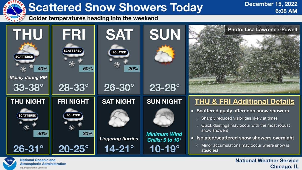
According to the National Weather Service, scattered gusty snow showers are expected Thursday afternoon. Similar weather is expected Friday, the weather service said.
Find out what's happening in Across Illinoisfor free with the latest updates from Patch.
Minor accumulations may occur where snow is steadiest, the weather service said. Some of the snow showers could be intense at times, especially late Thursday afternoon and evening.
Saturday also has a chance for isolated snow showers, and flurries are possible Saturday night, the weather service said.
Temperatures will start to cool as we approach the weekend. According to the weather service, the high for Thursday is 38, Friday has a high of 33, Saturday a high of 30 and Sunday a high of 28 degrees. Sunday night could also see wind chills in the single digits.
The weather service said even colder temperatures will arrive early next week.
Get more local news delivered straight to your inbox. Sign up for free Patch newsletters and alerts.