Weather
'Prolonged Lake Effect Snow' Timeline: When It Will Hit Chicago Area
Excessive cold will continue as snowfall rates cause poor visibility for drivers.

"A prolonged lake effect snow event" will likely impact parts of northeast Illinois starting early Friday morning through late Saturday, according to the National Weather Service.
The weather service said periods of significantly-impacted travel "appear increasingly likely."
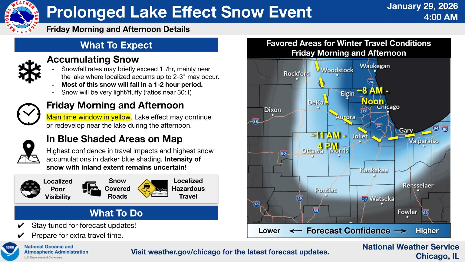
However, the locations impacted by the lake effect snow, and how much snow will accumulate, are still uncertain.
Find out what's happening in Across Illinoisfor free with the latest updates from Patch.
Snowfall rates may exceed 1 inch per hour, mostly near the lake, with localized accumulation of 2 to 3 inches in some places, the weather service said. Cold temperatures will also lead to less effective road treatments.
The closer to the lake you live, the more confidence there is that you'll see lake effect snow. However, gusty snow showers/squalls could develop farther inland along a cold front on Friday, the weather service said.
Find out what's happening in Across Illinoisfor free with the latest updates from Patch.
According to the weather service, the cold conditions will continue through the rest of the week, although a "gradual warming" is expected this weekend.
The high for Thursday is 17 degrees, with wind chills of -5 to -15 degrees, while temps could hit 19 degrees on Friday, with a wind chill of zero to -10 degrees. Saturday is expected to be slightly warmer, with a high of 24 degrees and wind chills of zero to -10 degrees.
Sunday's expected high is 27 degrees, with a slight chance of more snow.
Snowfall timing
Areas closer to the lake could see snowfall beginning between 8 a.m. and noon Friday, while areas further inland could see snowstorms begin between 11 a.m. and 4 p.m. Friday.
Between Friday evening and Saturday morning, intense snow bands with snowfall rates of more than an inch per hour are more likely closer to the lake and in northwest Indiana.
On Saturday, lingering intense snow bands in the morning will diminish throughout the day.
Residents are urged to stay tuned for forecast updates and prepare extra travel time if they will be on the road.
Get more local news delivered straight to your inbox. Sign up for free Patch newsletters and alerts.