Weather
Tornado Threat Possible, Severe Storms Could Bring Damaging Winds, Hail To Chicago Area
The primary tornado threat for severe weather will be far south of the Chicago area, mainly south of the Kankakee and Illinois River Valleys

Severe storms are possible Monday, as a "big complex of thunderstorms" will move into central Illinois later Monday morning, according to the National Weather Service.
"The complex of storms will act to limit the northward progression of a warm front later this afternoon, leading to the highest instability focusing across central and southern Illinois," the weather service said. So, the greatest risk for severe weather is south of Interstate 80.
Areas closer to Chicago could still see damaging winds or severe storms, but the primary tornado threat is for central and southern Illinois as some forecasters warn of a possible tornado outbreak.
Find out what's happening in Across Illinoisfor free with the latest updates from Patch.
"The highest tornado risk is mainly south of the Kankakee and Illinois River Valleys," the weather service said.
Scattered strong to severe storms are possible between 4 and 11 p.m. on Monday.
Find out what's happening in Across Illinoisfor free with the latest updates from Patch.
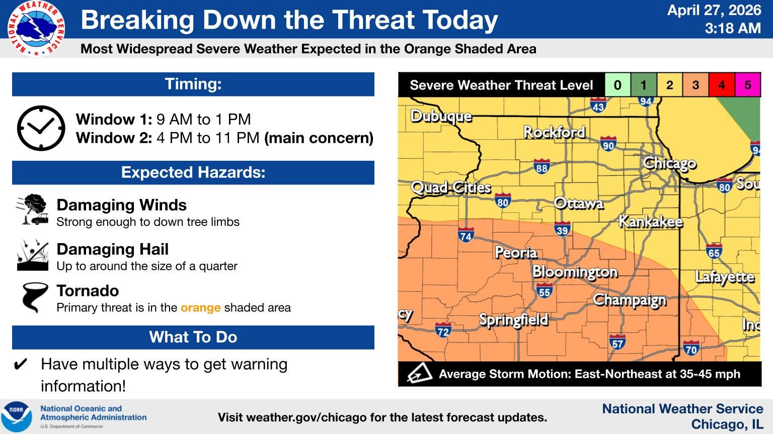
The weather service said there is also a low chance for damaging non-thunderstorms winds mainly north of Interstate 80, between noon and 3 p.m.
The high on Monday is 70 degrees, and temperatures will turn cooler on Tuesday and stay that way for the rest of the week. Tuesday has a high of 64, Wednesday a high of 62, Thursday a high of 62 and Friday a high of 59, according to the current forecast.
Here's a look at the forecast for the week:
Monday: A chance of showers before noon, then showers likely and possibly a thunderstorm between noon and 3pm, then a chance of showers after 3pm. Cloudy, with a high near 66. Windy, with a south southeast wind 15 to 20 mph increasing to 25 to 30 mph in the afternoon. Winds could gust as high as 45 mph. Chance of precipitation is 70%. New rainfall amounts between a quarter and half of an inch possible.
Monday night: Showers and possibly a thunderstorm before midnight, then a slight chance of showers between midnight and 1am. Low around 51. Breezy, with a south wind 15 to 20 mph becoming west after midnight. Winds could gust as high as 30 mph. Chance of precipitation is 80%. New precipitation amounts between a quarter and half of an inch possible.
Tuesday: Partly sunny, with a high near 62. West wind 10 to 15 mph, with gusts as high as 25 mph.
Tuesday night: A 20 percent chance of showers after 1am. Mostly cloudy, with a low around 47. North wind around 5 mph, with gusts as high as 10 mph.
Wednesday: Partly sunny, with a high near 57. North wind 10 to 15 mph, with gusts as high as 20 mph.
Wednesday night: Partly cloudy, with a low around 42.
Thursday: Mostly sunny, with a high near 58.
Thursday night: Mostly cloudy, with a low around 40.
Friday: Partly sunny, with a high near 54.
Friday night: Partly cloudy, with a low around 39.
Get more local news delivered straight to your inbox. Sign up for free Patch newsletters and alerts.