Weather
Spring-Like Weather To Bring Potential Storms To Chicago Area
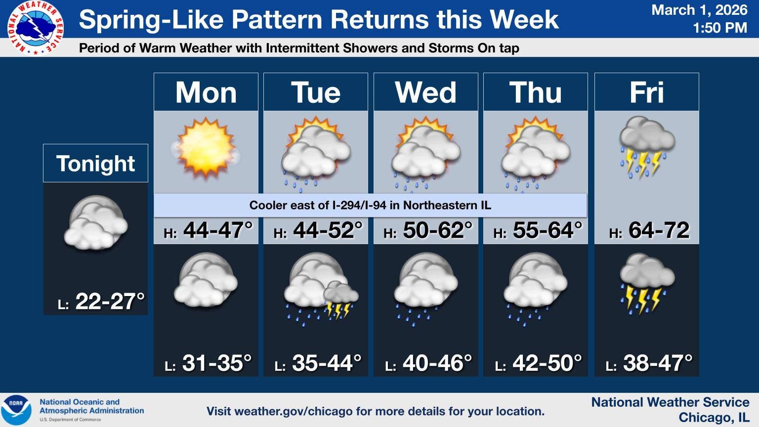
There is also a limited thunderstorm risk at times from Tuesday night through Friday.

A "spring-like pattern" is in store for the Chicago area this week, with "warming temperatures and intermittent showers and thunderstorms," according to the National Weather Service Chicago.
The coldest temperatures of the week will be on Monday, which has a high of 47 degrees. Monday should remain dry during the day, but "spotty" precipitation is possible late Monday, the weather service said.
The spotty showers could lead to "patchy slick spots," especially on untreated surfaces, according to the weather service.
Find out what's happening in Across Illinoisfor free with the latest updates from Patch.
There is also a limited thunderstorm risk at times from Tuesday night through Friday.
Temperatures will get warmer as the week goes on, with a high of 48 on Tuesday, 58 on Wednesday, 63 on Thursday and 72 degrees on Friday.
Find out what's happening in Across Illinoisfor free with the latest updates from Patch.
The weather service said rain and any storm chances for Tuesday through Wednesday evening "may end up focusing well south of I-80." Rain is likely late Wednesday into Thursday, and then later Friday.
"Temperatures later in the week will be unseasonably mild away from Lake Michigan, especially on Friday," the weather service said.
Here is a more detailed look at the weather this week, per the weather service:
MONDAY: Sunny, with a high near 46. East southeast wind 5 to 10 mph, with gusts as high as 15 mph.
MONDAY NIGHT: A slight chance of rain showers before 4 a.m., then a slight chance of rain or freezing rain between 4am and 5am, then a slight chance of rain showers after 5 a.m. Mostly cloudy, with a low around 32. East wind around 5 mph, with gusts as high as 10 mph. Chance of precipitation is 20%.
TUESDAY: A 40 percent chance of showers. Cloudy, with a high near 42. East wind around 5 mph.
TUESDAY NIGHT: A 40 percent chance of showers. Mostly cloudy, with a low around 37. Northeast wind around 5 mph, with gusts as high as 15 mph.
WEDNESDAY: A 50 percent chance of showers. Mostly cloudy, with a high near 48. East northeast wind 5 to 10 mph.
WEDNESDAY NIGHT: A chance of showers and thunderstorms, then showers likely and possibly a thunderstorm after midnight. Cloudy, with a low around 44. Chance of precipitation is 70%.
THURSDAY: Showers likely and possibly a thunderstorm before 2 p.m,. then a chance of showers and thunderstorms after 2 p.m. Mostly cloudy, with a high near 56. Chance of precipitation is 70%.
THURSDAY NIGHT: A chance of showers after midnight. Mostly cloudy, with a low around 43.
FRIDAY: Showers. Cloudy, with a high near 68.
FRIDAY NIGHT: Showers and possibly a thunderstorm. Mostly cloudy, with a low around 50.
Get more local news delivered straight to your inbox. Sign up for free Patch newsletters and alerts.