Weather
Tornadoes, Destructive Hail, Damaging Winds Possible With Tuesday's Severe Weather In IL
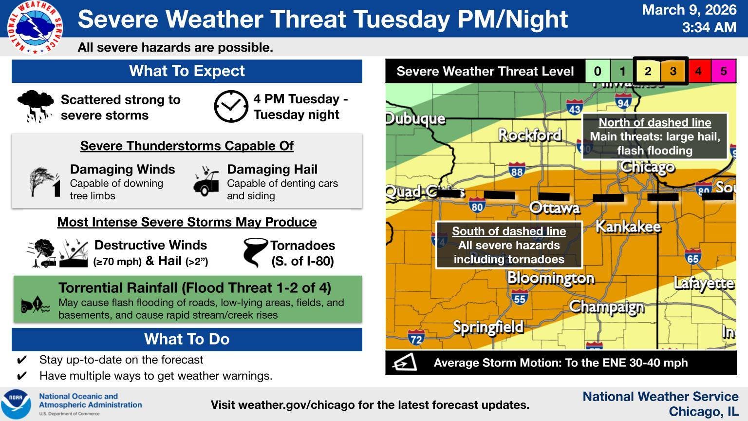
The weather service said is a level 2 or 3 out of 5 severe threat, depending where you live in the Chicago area.

Mild temperatures will start off the week, and also bring a severe storm threat on Tuesday, according to the National Weather Service.
Monday will have a high of 73 degrees, and should be sunny and dry all day. However, "an active stretch of weather will occur Tuesday afternoon into Wednesday with rounds of thunderstorms,some of which may be severe," the weather service said on its Facebook.
Tuesday will have a high in the 70s for areas south of Interstate 80, and a high in the 50s for areas north of I-80.
Find out what's happening in Across Illinoisfor free with the latest updates from Patch.
The weather service said is a level 2 or 3 out of 5 severe threat, depending where you live in the Chicago area.
"All severe hazards, including tornadoes, large to destructive hail, damaging winds and flash flooding are possible," the weather service said. Timing for the storms starts at 4 p.m. Tuesday, lasting through Tuesday night.
Find out what's happening in Across Illinoisfor free with the latest updates from Patch.
"The main threat for tornadoes exists mainly south of I-80," the weather service said.
According to the weather service, the threat for tornadoes will be highest near a warm front, and "warm fronts often stall near or just south of I-80 this time of year."
Here is a more detailed look at the weather for this week, per the weather service:
MONDAY: Sunny, with a high near 73. Southwest wind around 15 mph, with gusts as high as 25 mph.
MONDAY NIGHT: Partly cloudy, with a low around 54. South southwest wind 5 to 10 mph.
TUESDAY: A 50 percent chance of showers and thunderstorms after 1 p.m. Some of the storms could be severe. Partly sunny, with a high near 65. Southwest wind 5 to 10 mph becoming east in the afternoon. Winds could gust as high as 20 mph.
TUESDAY NIGHT: Showers and possibly a thunderstorm. Some of the storms could be severe. Low around 42. Northeast wind 10 to 15 mph becoming northwest after midnight. Winds could gust as high as 20 mph. Chance of precipitation is 100%.
WEDNESDAY: Rain and possibly a thunderstorm. High near 48. Breezy, with a northwest wind 15 to 20 mph, with gusts as high as 30 mph. Chance of precipitation is 80%.
WEDNESDAY NIGHT: Partly cloudy, with a low around 28.
THURSDAY: Mostly sunny, with a high near 46.
THURSDAY NIGHT: Rain likely, mainly after 1am. Cloudy, with a low around 38. Breezy.
FRIDAY: Mostly sunny, with a high near 50. Breezy.
FRIDAY NIGHT: Mostly cloudy, with a low around 32.
Get more local news delivered straight to your inbox. Sign up for free Patch newsletters and alerts.