Weather
Winter Storm Watch: 8 Inches Of Snow Possible For Chicago Area
The worst conditions will be from 11 a.m. to 9 p.m. on Friday, the weather service said.

ILLINOIS — A winter storm watch has been issued for the Chicago area as up to 8 inches of snow is possible on Friday. The National Weather Service has issued the watch starting Friday morning and ending Friday evening for Kane, DuPage, La Salle, Kendall, Grundy, Kankakee, Cook and Will counties.
The weather service said rain will change over to heavy, wet snow, with total snow accumulations of 5 to 8 inches possible. Winds could also be as high as 45 mph.
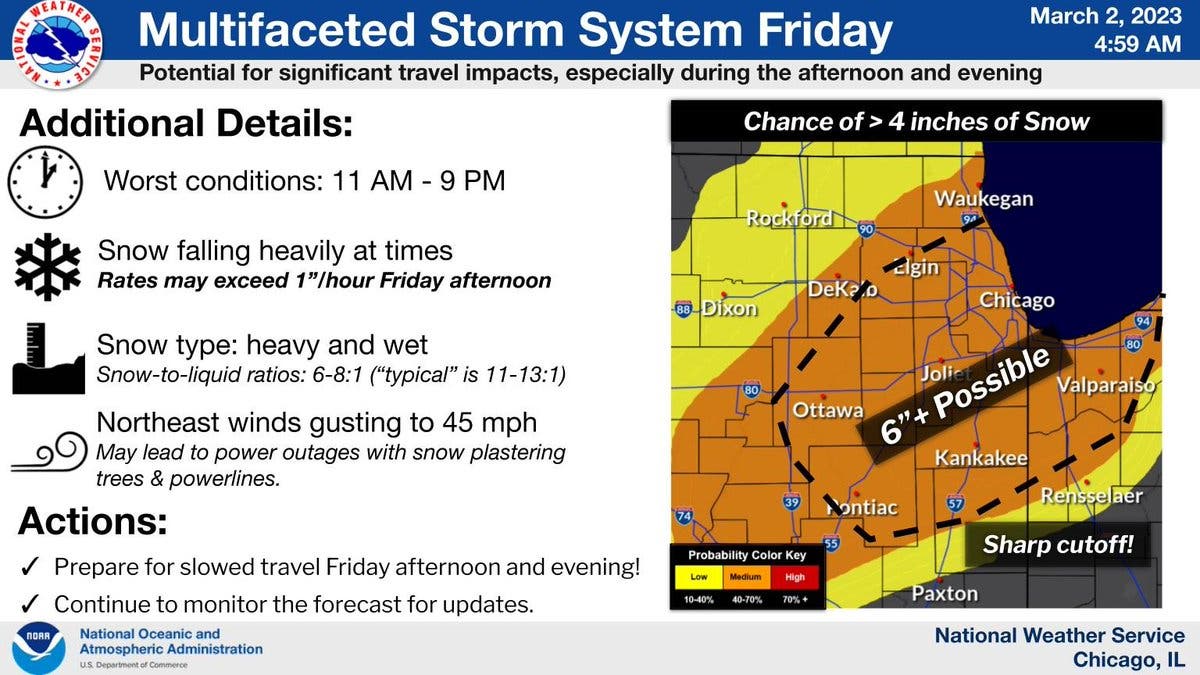
The storm will most likely impact the Friday afternoon and evening commutes, according to the weather service.
Find out what's happening in Across Illinoisfor free with the latest updates from Patch.
Snowfall rates of 1 to 2 inches per hours are possible in a narrow zone on Friday afternoon, the weather service said. There is also a potential for scattered power outages.
The weather service said an "unusual amount of uncertainty remains" with the track of this storm still. There is still a scenario where the storm shifts further north, bringing the heaviest snow northwest of Interstate 55.
Find out what's happening in Across Illinoisfor free with the latest updates from Patch.
According to AccuWeather, the storm could bring 6 to 10 inches of snow to Chicago.
"People should expect impacts from a snowstorm Friday in Chicago, Detroit and Milwaukee, along with a large number of flight delays and cancellations in the major airport hubs," AccuWeather said.
For the Joliet area, the private forecaster gave a 32 percent probability for 6 to 10 inches of snow, and a 29 percent probability for 10 to 15 inches of snow.
Get more local news delivered straight to your inbox. Sign up for free Patch newsletters and alerts.