Weather
Snowfall Estimates Released As Winter Weather Advisory Issued For Chicago Area
The winter weather advisory is in effect for Lake, DuPage and Cook counties, with lake effect snow expected through Saturday.

A winter storm watch and a winter weather advisory have been issued for parts of the Chicago area as snow is possible Friday through the day. According to the National Weather Service, a quick 1 to 3 inches of snow is expected within a few hours on Friday morning for areas in the winter weather advisory.
For the winter storm watch area, heavy lake effect snow is possible, the weather service said. Snow is first expected over a short period on Friday evening, then again late Friday through Saturday morning. Snow accumulations of 6 or more inches are possible.
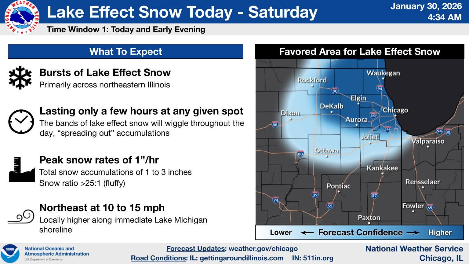
The winter weather advisory is in effect from 9 a.m. to 6 p.m. Friday; the winter storm watch is in effect from Friday evening through Saturday morning.
Find out what's happening in Across Illinoisfor free with the latest updates from Patch.
The winter weather advisory is in effect for Lake, DuPage and Cook counties; while the winter storm watch is for central and south Cook County.
Peak snow rates of 1 inch per hour are possible, the weather service said. The snow will also last a few hours at any given location, so snow accumulations will be limited.
Find out what's happening in Across Illinoisfor free with the latest updates from Patch.
Friday and Saturday will also still have cold conditions, with wind chills as low as 15 below zero on Friday night. Temperatures warm slightly on Sunday and into next week, with a high of 27 on Sunday and a high of 30 on Monday.
"Another chance for snow looks to come in the Sunday night through early Monday morning time frame," the weather service said.
FRIDAY: Snow showers, mainly after 10 a.m. High near 19. Wind chill values as low as -8. Northwest wind 5 to 10 mph becoming northeast in the afternoon. Winds could gust as high as 15 mph. Chance of precipitation is 90%. Total daytime snow accumulation of less than one inch possible.
FRIDAY NIGHT: Snow showers likely, mainly before 9 p.m. Mostly cloudy, with a low around 8. Wind chill values as low as -7. North northwest wind 10 to 15 mph, with gusts as high as 20 mph. Chance of precipitation is 70%. New snow accumulation of less than a half inch possible.
SATURDAY: Isolated snow showers between 9 a.m. and noon. Partly sunny, with a high near 24. Wind chill values as low as -7. North northwest wind 10 to 15 mph, with gusts as high as 20 mph. Chance of precipitation is 20%.
SATURDAY NIGHT: Mostly clear, with a low around 6. North northwest wind around 5 mph becoming calm in the evening. Winds could gust as high as 10 mph.
SUNDAY: Sunny, with a high near 26. South southwest wind 5 to 10 mph, with gusts as high as 15 mph.
SUNDAY NIGHT: A 40 percent chance of snow. Mostly cloudy, with a low around 18.
Get more local news delivered straight to your inbox. Sign up for free Patch newsletters and alerts.