Weather
Smoky Haze, Severe Storms In Labor Day Forecast
Hot temps are also in the forecast for Labor Day but cooler weather is on its way in the week ahead for the Chicago area.

For those who noticed a smell of smoke and wondered last Thursday, "what is that?", you may notice a similar smell today across northern Illinois. There also may be a "smoky sky" and a light haze may be noticeable over northern Illinois and northwest Indiana, according to the National Weather Service. And just like last week, the smoky smell and sky will likely be coming from wildfire smoke from fires in the western U.S.
A hazardous weather outlook has been issued for counties across northeast Illinois for Monday due to an elevated thunderstorm risk. Thunderstorms are likely to develop this afternoon ahead of a southward moving cold front, according to the National Weather Service.
Find out what's happening in Chicagofor free with the latest updates from Patch.
While some widely scattered showers and thunderstorms will be possible across far northern Illinois
with this front early Monday afternoon, these storms are not likely to be severe. However, there is a higher threat for severe thunderstorm development from mid- to late-afternoon, especially along and south of a line from near Pontiac Illinois to Valparaiso Indiana.
Strong damaging winds look to be the main severe threat with these storms, though some hail to the size of
quarters will also be possible. The threat for thunderstorms are expected to end by early this evening.
Find out what's happening in Chicagofor free with the latest updates from Patch.
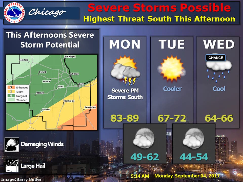
A strong cold front is also move across the area on Monday. High temps on Monday for the Chicago area should be between 83 and 89 degrees. Much cooler conditions will follow for the rest of this week with highs between 67 and 72 in the forecast on Tuesday and high temps between 64 and 66 on Wednesday.
The cold front is also expected to create dangerous swim conditions across northwest Indiana beaches Monday afternoon through Tuesday night as high waves develop fairly quickly when the front arrives, according to the National Weather Service.
Here is a more detailed look at the forecast for the week ahead:
- MONDAY: Partly cloudy. A 30 percent chance of showers and thunderstorms early this afternoon. Highs in the mid 80s. southwest winds 10 to 20 mph in the morning becoming west in the afternoon. Gusts up to 30 mph.
- MONDAY NIGHT: Partly cloudy in the evening then clearing. Lows in the mid 50s in the suburbs...but in the upper 50s downtown. Northwest winds 10 to 15 mph.
- TUESDAY: Sunny in the morning then becoming partly sunny. Highs around 70. Northwest winds 10 to 20 mph.
- TUESDAY NIGHT: Partly cloudy with a 20 percent chance of showers. Lows in the upper 40s in the suburbs...but in the lower 50s downtown. Northwest winds 10 to 15 mph.
- WEDNESDAY: Partly sunny with a 30 percent chance of showers. Highs in the mid 60s. North winds 10 to 15 mph.
- WEDNESDAY NIGHT: Partly cloudy with a 30 percent chance of showers. Lows in the upper 40s in the suburbs...but in the lower 50s downtown.
- THURSDAY: Partly sunny with a 30 percent chance of showers. Highs in the mid 60s.
- THURSDAY NIGHT: Partly cloudy in the evening then clearing. Lows in the upper 40s in the suburbs...but in the lower 50s downtown.
- FRIDAY THROUGH SATURDAY: Clear. Highs in the lower 70s. Lows near 50 in the suburbs...but in the mid 50s downtown.
Get more local news delivered straight to your inbox. Sign up for free Patch newsletters and alerts.

