Weather
Easter Weekend Weather for Chicago Area: Thunderstorms, Temps in 80s
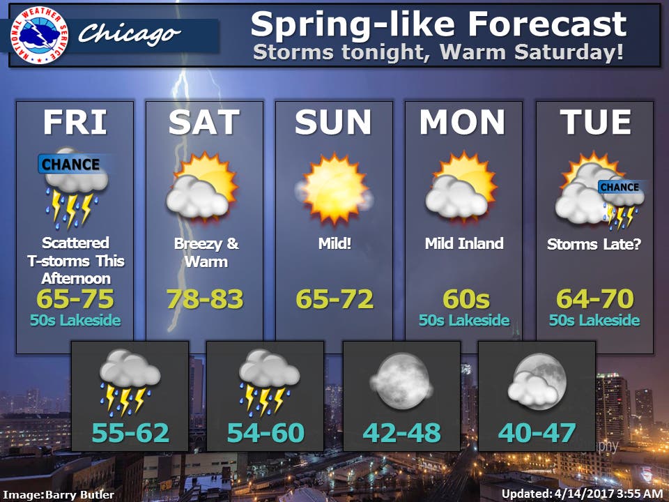
A look at the weather forecast for the coming days for the Chicago area.


Scattered thunderstorms and 80-degree weather is in the forecast for the coming days before temps cool for Easter Sunday for the Chicago area.
On Friday, scattered thunderstorms are likely to develop later in the afternoon and into the evening ahead of a warm front. High temps between 65 and 75 degrees is in the forecast while temps will only reach highs in the 50s near the lake, according to the National Weather Service.
Saturday should be breezy and warm. High temps between 78 and 83 degrees are expected across the Chicago area while wind gusts could reach as high as 30 mph. More showers and storms are possible Saturday night, the National Weather Service reports.
Find out what's happening in Chicagofor free with the latest updates from Patch.
Easter Sunday should be pleasant with temps reaching highs between 65 and 72 degrees. Partly cloudy skies are likely in the morning but then will clear.
High temps in the 60s inland and 50s near the lake look to be the norm for the majority of next week.
Find out what's happening in Chicagofor free with the latest updates from Patch.
Here is more detailed look at the forecast for the coming days:
FRIDAY: Mostly cloudy. A chance of showers and thunderstorms in the afternoon. Highs in the mid 60s to lower 70s inland...but only in the upper 40s to mid 50s near the lake. Southeast winds 10 to 15 mph. Chance of precipitation 40 percent.
FRIDAY NIGHT: Mostly cloudy. Showers with thunderstorms likely in the evening, then a chance of showers after midnight. Temperatures nearly steady in the upper 50s. South winds 10 to 20 mph. Near the lake, gusts up to 30 mph after midnight. Chance of precipitation 80 percent.
SATURDAY: Partly cloudy. Breezy, warm. Highs around 80. Southwest winds 15 to 25 mph with gusts up to 30 mph.
SATURDAY NIGHT: Partly cloudy with chance of showers and thunderstorms in the evening, then cloudy with showers and thunderstorms likely after midnight. Lows in the upper 50s. Southwest winds 10 to 20 mph with gusts up to 30 mph. Chance of precipitation 60 percent.
SUNDAY: Partly cloudy in the morning then clearing. Highs in the upper 60s. West winds 10 to 20 mph.
SUNDAY NIGHT: Mostly clear. Lows in the mid 40s.
MONDAY: Partly cloudy. Highs around 60 inland...but only in the lower 50s near the lake.
Get more local news delivered straight to your inbox. Sign up for free Patch newsletters and alerts.

