Weather
HAZARDOUS WEATHER OUTLOOK: Accumulating Snow Possible For Chicago Area
A look at this weekend's forecast for the Chicago area.


The weekend will start out windy and cold and wrap up Sunday night with accumulating snow that could continue into Monday and possibly even Tuesday for portions of the Chicago area.
Meanwhile, temperatures more typical of late January or early February will remain in place for much of the coming week, according to the National Weather Service.
On Friday, wind gusts reaching as high as 30 mph added to the chill in the air. High temps were expected to reach between 26 and 35 degrees for the Chicago area with wind chills only in the teens to low 20s.
Find out what's happening in Chicagofor free with the latest updates from Patch.
The windy conditions coupled with very dry air and minimum relative humidity of 25 to 30 percent could create for a greater weather risk and greater chance that a fire could spread.
“In spite of the very cold airmass, these conditions will create near red flag conditions today,” according to a hazardous weather outlook issued for counties throughout the Chicago area.
Find out what's happening in Chicagofor free with the latest updates from Patch.
The chilly and windy weather will continue on Saturday. High temps will reach between 30 and 37 degrees for the area.
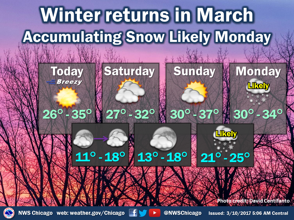
Sunday could prove to be the warmest day of the weekend with high temps between 27 and 32 degrees in the forecast, according to the National Weather Service. And on Sunday night, accumulating snow is becoming increasingly more likely. That snow could continue through Monday night with a few to several inches expected. Lake effect snow is possible Monday night into Tuesday.
“Most of the area has experienced very little snow since mid December, so travelers should be prepared for winter driving conditions to begin the work week, with commute impacts expected, especially Sunday night into Monday when it will be colder and drier and thus snow will be easier to accumulate,” according to an update Friday from the National Weather Service.
Here is a more detailed look at the forecast for the coming days:
- FRIDAY: Mostly sunny. Blustery. Highs in the lower 30s. Northwest winds 15 to 25 mph with gusts up to 30 mph.
- FRIDAY NIGHT: Partly cloudy. Lows 12 to 16. Northwest winds 10 to 15 mph.
- SATURDAY: Partly sunny. Highs in the upper 20s. North winds 10 to 15 mph.
- SATURDAY NIGHT: Partly cloudy in the evening then clearing. Lows 13 to 17. Northeast winds 5 to 10 mph in the evening shifting to the northwest after midnight.
- SUNDAY: Partly cloudy. Highs in the lower 30s. Northwest winds 5 to 10 mph in the morning shifting to the northeast in the afternoon.
- SUNDAY NIGHT: Cloudy with snow. Some snow accumulation possible. Lows in the mid 20s. Chance of precipitation 80 percent.
- MONDAY: Light snow. Some snow accumulation possible. Highs in the lower 30s. Chance of precipitation 80 percent.
- MONDAY NIGHT: Mostly cloudy with light snow likely. Some snow accumulation possible. Lows in the lower 20s. Chance of precipitation 70 percent.
- TUESDAY: Partly sunny. Snow likely in the morning, then a chance of snow in the afternoon. Highs in the lower 30s. Chance of precipitation 60 percent.
Get more local news delivered straight to your inbox. Sign up for free Patch newsletters and alerts.

