Weather
HAZARDOUS WEATHER OUTLOOK: Thunderstorms Possible This Afternoon, Snow Expected Overnight
A look at this weekend's forecast for the Chicago area.


When it comes to the weather, we could have an interesting 24 hours ahead of us.
A hazardous weather outlook has been issued for northeast Illinois as scattered thunderstorms are possible Friday afternoon and could continue into early this evening, according to the National Weather Service. These storms could bring a limited chance for a tornado, hail or winds in excess of 60 mph.
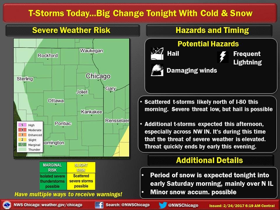
Later this afternoon, temperatures are expected to drop off steeply and will continue to drop overnight. Gusty winds will add to the chill with gusts up to 30 mph possible after midnight.
Find out what's happening in Chicagofor free with the latest updates from Patch.
A period of snow is also expected Friday night and will continue into Saturday morning for the Chicago area, according to the National Weather Service. Some minor accumulations of snow and sleet are possible, especially near the Wisconsin border where around an inch of fresh snow could fall.
A high around 30 and partly cloudy skies are expected on Saturday for the Chicago area — with gusty winds again expected — while rain, highs in the mid-40s, gusty winds and mostly cloudy skies are possible on Sunday.
Find out what's happening in Chicagofor free with the latest updates from Patch.
Here is a more detailed look at the forecast for the coming days:
- Rest of Today: Cloudy with a 40 percent chance of showers and thunderstorms. Areas of fog late in the morning, then patchy fog in the afternoon. Highs in the 40s to mid 50s inland...but only in the 40s near the lake. Northeast winds 10 to 15 mph late in the morning shifting to the northwest in the afternoon.
- Friday Night: Cloudy. Chance of rain showers and a slight chance of sleet in the evening, then snow showers and rain showers likely after midnight. Snow and sleet accumulation up to 1 inch. Lows in the upper 20s. West winds 10 to 20 mph. Gusts up to 30 mph after midnight. Chance of precipitation 60 percent.
- Saturday: Mostly cloudy. A 50 percent chance of snow showers in the morning. Blustery. Highs around 30. West winds 15 to 25 mph with gusts up to 30 mph.
- Saturday Night: Partly cloudy. Lows in the lower 20s. West winds 10 to 15 mph.
- Sunday: Mostly cloudy. A 20 percent chance of rain in the afternoon. Blustery. Highs in the mid 40s. Southwest winds 15 to 25 mph with gusts up to 30 mph.
- Sunday Night: Mostly cloudy. Lows around 30.
- Monday: Partly sunny. Highs in the upper 40s.
Get more local news delivered straight to your inbox. Sign up for free Patch newsletters and alerts.

