Weather
How Long Will Record Warmth Last?
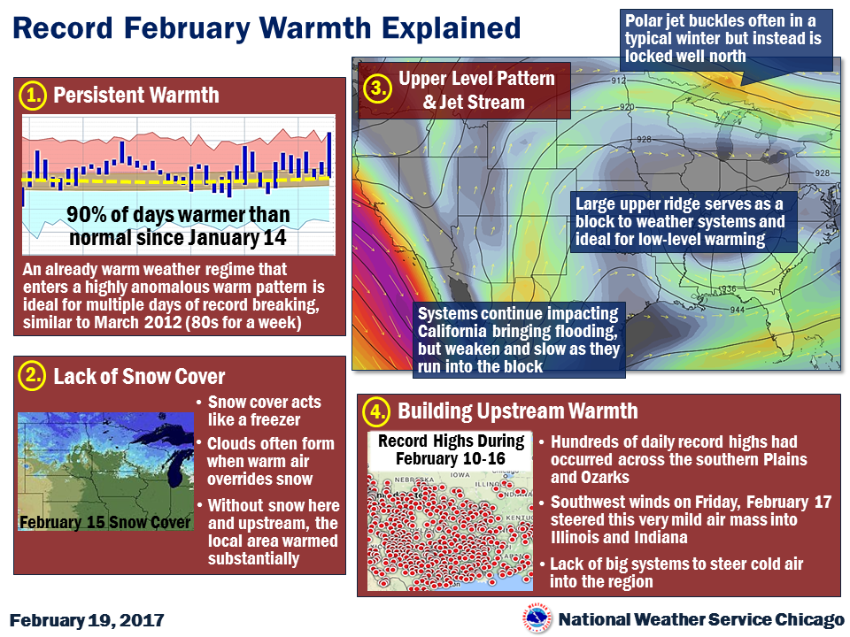
The Chicago area has had three days in a row of record warm temperatures with more warmth in the forecast this week.


Chicago has seen three days in a row of record high temps.
As of early Sunday afternoon, the high temperature reached 66 degrees at O’Hare International Airport in Chicago and 64 degrees in Rockford, breaking previous-set records for Feb. 19. Those records were set in 1930 in Chicago, when temps hit 65 degrees, and that same day in Rockford, when temps hit 63. With temperatures still rising this afternoon, the final record for the day is yet to be seen, according to the National Weather Service.
Sunday marked the third day in a row of record-breaking temps.
Find out what's happening in Chicagofor free with the latest updates from Patch.
On Saturday, temps topped out at 70 degrees at O’Hare International Airport. This marked only the fourth time in February since 1871 that temps reached into the 70s, according to the National Weather Service.
At about 1 p.m. on Saturday, Chicago had warmer temps than Phoenix, AZ, and El Paso Texas, which were both at 60 degrees; and Los Angeles, CA, and Nashville, TN, which were at 54 degrees.
It was much of the same on Friday when Chicago O’Hare set a new record high, reaching 67 degrees, and Rockford’s previous record was shattered when temps reached 66 degrees there.
Find out what's happening in Chicagofor free with the latest updates from Patch.
So, how long can our good fortune and this record warmth last?
Above-average temperatures are expected to continue through mid-week and lead to more record-breaking warmth. Here is a look at forecasted high temps for the area for the coming days:
- Monday: Highs between 63 and 70 degrees; mid-50s by the lake. Previous record high for Chicago was set in 1930 when temps reached 64 degrees.
- Tuesday: Highs between 63 and 67 degrees. Previous record for Chicago was set in 1930 when temps reached 67 degrees.
- Wednesday: Highs near 70 at O’Hare. The previous record was set in 1922 when temps reached 68 degrees
After that, temps in the 50s are in the forecast for Thursday and Friday before it cools back into the 30s on Saturday, according to the National Weather Service.
Fog, Storms on Monday
Fog is expected to develop Sunday night and continue into Monday morning. There is a chance for afternoon showers on Monday and isolated thunderstorms. A few thunderstorms and rain is expected Monday night into Tuesday morning. Mostly cloudy skies are expected through the day.
Here is a detailed look at the forecast for the rest of the week:
- MONDAY: Areas of fog before 10am. Otherwise, mostly cloudy, with a high near 66. South southeast wind 5 to 15 mph, with gusts as high as 25 mph.
- MONDAY NIGHT: Showers and possibly a thunderstorm before 3am, then a chance of showers. Low around 52. South southeast wind 10 to 15 mph becoming west after midnight. Winds could gust as high as 25 mph. Chance of precipitation is 90%.
- TUESDAY: A 20 percent chance of showers before noon. Mostly sunny, with a high near 66. West wind around 10 mph.
- TUESDAY NIGHT: Mostly clear, with a low around 46.
- WEDNESDAY: Mostly sunny, with a high near 70.
- WEDNESDAY NIGHT: Partly cloudy, with a low around 44.
- THURSDAY: Partly sunny, with a high near 54.
- THURSDAY NIGHT: Rain likely, then rain and possibly a thunderstorm after midnight. Cloudy, with a low around 40.
- FRIDAY: Rain likely and possibly a thunderstorm. Mostly cloudy, with a high near 53.
- FRIDAY NIGHT: A chance of rain and snow. Mostly cloudy, with a low around 30. Breezy.
- SATURDAY: Partly sunny, with a high near 37. Breezy.
Get more local news delivered straight to your inbox. Sign up for free Patch newsletters and alerts.

