Weather
Chicagoland Weather: Wet Week Ahead, More Flooding Possible for Chicago Area
A look at the weather forecast for this week for the Chicago area.

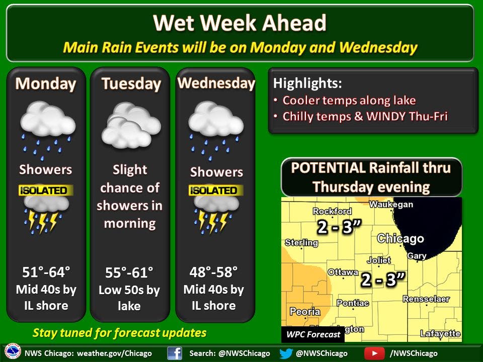
After getting drenched by heavy rain last week, a wet week is ahead for the Chicago area with two to three more inches of rain in the forecast and the possibility for flooding .
Two strong low pressure area will affect the area -- the first on Monday through Monday evening and then another on Wednesday through Thursday, according to the National Weather Service. Heavy rain rates and significant rainfall amounts are expected with both storm systems.
For the first system, rainfall amounts approaching or exceeding one inch could occur along the
Interstate 55 corridor though significant rain remains possible area wide. For the mid- to late-week system, heavy rainfall is possible area wide depending on the track of the low pressure area.
Find out what's happening in Chicagofor free with the latest updates from Patch.
Between the two storms, at least parts of the area could experience total rainfall amounts of 2 to 3 inches or more. Given the saturated ground and ongoing minor river flooding from heavy rains on March 30, this week's wet weather could result in flooding of low lying areas and renewed sharp river rises, according to the National Weather Service.
Isolated thunderstorms are also possible on Monday and Wednesday and there is a slight chance of rain on Tuesday morning. High temps between 51 and 64 degrees are in the forecast on Monday while high temps between 55 and 61 degrees are in the forecast on Tuesday and temps between 48 and 58 degrees are expected on Wednesday.
Find out what's happening in Chicagofor free with the latest updates from Patch.
Chillier temperatures and high wind gusts are in the forecast for Thursday and Friday.
Here is a more detailed look at the forecast for the coming week:
- SUNDAY NIGHT: Cloudy with a 40 percent chance of showers. Lows in the mid 40s. Southeast winds around 10 mph.
- MONDAY: Showers in the morning, then showers and a slight chance of thunderstorms in the afternoon. Highs in the upper 40s to mid 50s. Highs in the mid 50s inland...but only in the mid 40s near the lake. East winds 10 to 15 mph. Chance of precipitation 100 percent.
- MONDAY NIGHT: Cloudy. Rain and a slight chance of thunderstorms in the evening, then light rain likely after midnight. Lows in the mid 40s. Northeast winds 10 to 15 mph in the evening shifting to the northwest after midnight. Chance of precipitation 80 percent.
- TUESDAY: Mostly cloudy. A 30 percent chance of light rain in the morning. Highs in the mid 50s. Northwest winds 10 to 20 mph.
- TUESDAY NIGHT: Mostly cloudy. A 50 percent chance of light rain after midnight. Lows in the upper 30s. Northeast winds 10 to 15 mph.
- WEDNESDAY: Rain. Highs in the upper 40s inland...but only in the mid 40s near the lake. Chance of precipitation 80 percent.
- WEDNESDAY NIGHT: Windy. Rain in the evening, then rain and snow likely after midnight. Lows in the upper 30s. Chance of precipitation 80 percent.
- THURSDAY: Windy, cloudy. Chance of rain and snow in the morning, then a chance of rain in the afternoon. Highs in the mid 40s. Chance of precipitation 50 percent.
- THURSDAY NIGHT: Mostly cloudy. Chance of rain in the evening. Lows in the mid 30s. Chance of precipitation 30 percent.
- FRIDAY AND FRIDAY NIGHT: Mostly clear. Highs in the upper 40s inland...but only in the mid 40s near the lake. Lows in the mid 30s.
- SATURDAY: Mostly sunny. Highs in the upper 50s.
Get more local news delivered straight to your inbox. Sign up for free Patch newsletters and alerts.