Weather
Multiple Rounds Of Storms Possible This Week For Chicago Area
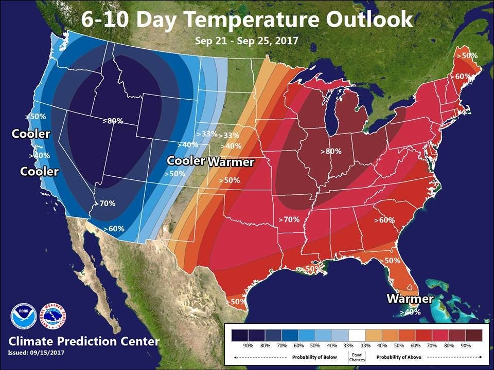
Meanwhile, the Chicago area should expect above normal temps through late September, according to the National Weather Service.


The Chicago area could see multiple rounds of storms through Wednesday. A hazardous weather outlook has been issued for northeast and north central Illinois and northwest Indiana as storms are in the forecast Sunday evening, according to the National Weather Service. But the bulk of those storms, which could produce gusty winds and small hail, should be east of Interstate 57.
But rain and storms will continue as the work week gets underway. Late on Monday afternoon and evening, widespread measurable rainfall is expected. The Chicago area will remain in a "busy pattern with multiple chances of storms" possible through Wednesday, according to the National Weather Service.
Meanwhile, many in the Chicago area will be powering up their air conditioners, if they haven't already, in the week ahead. Hot and humid temps returned in recent days and weather officials are predicting that very warm weather pattern could continue through late September.
Find out what's happening in Chicagofor free with the latest updates from Patch.
- (For more information on this and other neighborhood stories, subscribe to Patch to receive daily newsletters and breaking news alerts.)
The NOAA NWS Climate Prediction Center released its six- to 10-day temperature outlook for Sept. 21 through 25, which shows an 80 percent probability of temps averaging well above normal. During this time, chances will be elevated for above normal precipitation as well.
Here is a more detailed look at the weather forecast for the week ahead for the Chicago area:
Find out what's happening in Chicagofor free with the latest updates from Patch.
- Sunday night: Partly cloudy. Lows in the upper 50s in the suburbs... But in the lower 60s downtown. North winds 10 to 15 mph.
- Monday: Partly sunny. A 20 percent chance of showers in the afternoon. Highs in the mid 70s inland...but only in the lower 70s near the lake. Northeast winds 5 to 10 mph.
- Monday night: Mostly cloudy with a 40 percent chance of showers. Lows in the lower 60s. East winds 5 to 10 mph in the evening becoming southeast after midnight.
- Tuesday: Partly sunny with chance of showers and a slight chance of thunderstorms. Highs around 80 inland...but only in the mid 70s near the lake. Southeast winds 5 to 10 mph. Chance of precipitation 30 percent.
- Tuesday night: Partly cloudy. Lows in the mid 60s. Southeast winds 5 to 10 mph.
- Wednesday: Partly cloudy in the morning then becoming mostly sunny. Highs in the upper 80s.
- Wednesday night: Mostly clear in the evening then becoming partly cloudy. Lows in the mid 60s.
- Thursday: Partly cloudy in the morning then becoming mostly sunny. Highs in the mid 80s.
- Thursday Night Through Sunday: Partly cloudy. Lows in the mid 60s. Highs in the mid 80s inland...but only in the lower 80s near the lake.
Get more local news delivered straight to your inbox. Sign up for free Patch newsletters and alerts.

